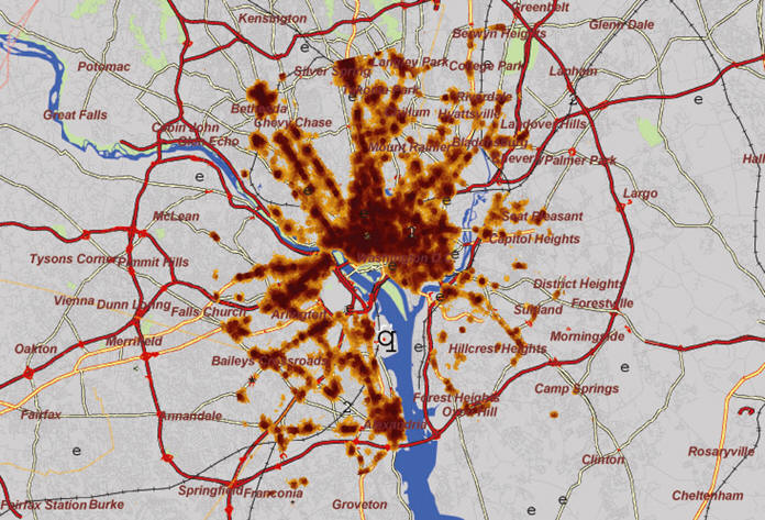
In the Washington, D.C. metropolitan region, a security
agency works to predict where threats are located. Where might
resources be most effectively allocated to counter or disrupt the
threats? How can we reduce the search area for targets of interest?
Working in teams that interweave analysts' involvement with powerful
technology, agencies employ a sophisticated analysis and data fusion
engine that is helping experts with different efforts around the world.
They leverage a geospatial intelligence solution from SPADAC to help
make critical decisions, so that better and faster risk mitigation and
resource allocation decisions can be made.
Integrating Disparate Information for a Common Picture
For example, if a metropolitan area were experiencing a wave of muggings at ATM machines, domain and subject matter experts would pull together information on lighting, traffic patterns, specific locations of ATMs, police patrol routes and nearby businesses. The software then leverages patented pattern analysis methodology to pinpoint other ATMs in the area whose geographical characteristics match those where the previous muggings had taken place.
In a visual representation, the most similar areas appear in bright red. Less similar but still plausible areas appear in yellow. These hotspots are one way to narrow the areas where resources should be focused. In the ATM example, local law enforcement could increase patrols in the areas highlighted as most similar, increasing their chances of minimizing criminal behavior or apprehending the robber.
For each problem, the SPADAC solution creates an assessment, called a GeoSignature, or a set of criteria that describes a particular event type. GeoSignatures are used to better understand the problem, or to make forecasts about the future locations of similar events. Using a process known as signature transfer, the GeoSignature created to answer a question in one geographic area can be used as a baseline for analyzing similar events in another geographic area. If another city were to suddenly find itself dealing with a large number of ATM assaults, the signature from the first city could be easily transferred, dramatically reducing the amount of time necessary for intelligence gathering and analysis.
This methodology has numerous applications within government organizations, particularly for military, intelligence and homeland security initiatives where geospatial information is key. Predicting terrorist activity, searching for certain types of facilities, planning missions and applying resources are but a few examples. The challenges SPADAC technology can tackle are limited only by the decision makers' need and imagination. And the results are real, providing predictive analysis that is consistently accurate.
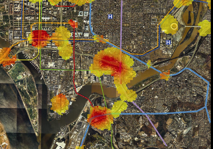
Tracking the Snipers
In October 2002, the Washington, D.C. metropolitan region was paralyzed by random sniper attacks. An unknown assailant was shooting and killing people in public places. Because no one knew where the sniper would strike next, police resources were scattered. Rather than preventing attacks, they were limited to rushing to the scene to search for clues - and because many of the attacks happened near major highways, the assailant was gone by the time law enforcement arrived. Public fear in the region was palpable as many people declined to go outdoors or dramatically modified their daily routines.
SPADAC created a model to analyze the situation after the fact. Approximately 108 variables, including transportation infrastructure, hydrology, landmarks and demographics were included in the analysis. They were joined by event data from the previous attacks. The key question of "Where are the criminals most likely to strike again?" was rephrased into a more pointed question - "Where should law enforcement resources be focused?"
After iterative analysis of the first nine events, SPADAC was able to hone in on the tactics, techniques and procedures (TTPs) of the snipers, and using the model, projected the next five events to occur in a non-contiguous geographic area representing less than seven percent of the Washington metropolitan region. Because this was a blind study, the analysis team was able to verify that the reduced area identified by the SPADAC model had a 90 percent confidence level. SPADAC's methodology is a powerful predictive tool that, when available to law enforcement officials or other security forces, enables effective allocation of scarce security resources to mitigate the threats at hand.
The success of this blind study showed that the SPADAC methodology is useful in narrowing a search field when the target is stationary. To develop a tool for use when a target is traveling, SPADAC looked to nature.
Mimicking Nature
SPADAC's AntFarm is a methodology modeled after the biological paradigm of a colony of ants. Ants are able to find the optimal route between their colony and a food source simply by leaving information in their local environment. This prototype system sends out "ants" to explore a model of an environment or network. The network is comprised of nodes, or destinations, like buildings or cities, and edges, or transportation hubs, like roads or train routes.
AntFarm provides the analyst with any possible route between two places, with scores for each route denoting the likelihood of a target using that route. AntFarm uses positive and negative factors to predict the route a target might take. For example, a fugitive would be attracted to a route by the presence of natural cover such as a wooded area, but repelled by a nearby police substation. Analysts can load as many factors as they like into the system and weight them accordingly.
In a disaster planning situation, emergency management authorities could predict the most likely routes people would use to evacuate a city, and subsequently plan their official evacuation routes accordingly. Military agencies and law enforcement can use AntFarm to predict how a fugitive might attempt to avoid surveillance or capture. Once all factors are loaded, AntFarm delivers intelligence rapidly. In a performance sample, it took 100,000 ants about five minutes to search 10,000 nodes and 15,000 edges.
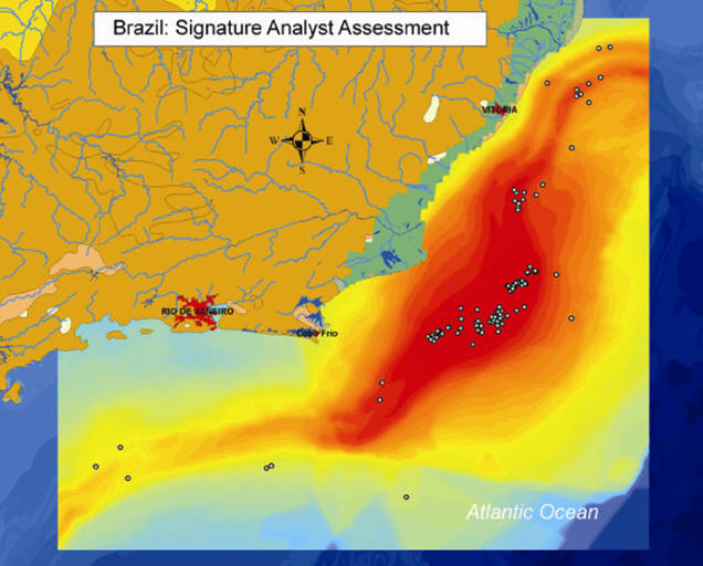
Combining the Analyst Perspective with Geospatial Information
Recently, SPADAC assisted border control authorities in determining where tunnels were most likely to be located along the border. Other potential applications of SPADAC's methodologies include identifying potential trafficking routes for contraband, screening at ports for high risk vessels and cargo, protecting corporate assets or staff in hostile environments, and optimizing resource allocation decisions in counter-contraband operations.
Intelligence technology has grown by leaps and bounds, but it will never eliminate the need for analysts. Rather, by using sophisticated predictive technology, the analyst will become more accurate and more efficient.
Integrating Disparate Information for a Common Picture
For example, if a metropolitan area were experiencing a wave of muggings at ATM machines, domain and subject matter experts would pull together information on lighting, traffic patterns, specific locations of ATMs, police patrol routes and nearby businesses. The software then leverages patented pattern analysis methodology to pinpoint other ATMs in the area whose geographical characteristics match those where the previous muggings had taken place.
 |
In a visual representation, the most similar areas appear in bright red. Less similar but still plausible areas appear in yellow. These hotspots are one way to narrow the areas where resources should be focused. In the ATM example, local law enforcement could increase patrols in the areas highlighted as most similar, increasing their chances of minimizing criminal behavior or apprehending the robber.
For each problem, the SPADAC solution creates an assessment, called a GeoSignature, or a set of criteria that describes a particular event type. GeoSignatures are used to better understand the problem, or to make forecasts about the future locations of similar events. Using a process known as signature transfer, the GeoSignature created to answer a question in one geographic area can be used as a baseline for analyzing similar events in another geographic area. If another city were to suddenly find itself dealing with a large number of ATM assaults, the signature from the first city could be easily transferred, dramatically reducing the amount of time necessary for intelligence gathering and analysis.
This methodology has numerous applications within government organizations, particularly for military, intelligence and homeland security initiatives where geospatial information is key. Predicting terrorist activity, searching for certain types of facilities, planning missions and applying resources are but a few examples. The challenges SPADAC technology can tackle are limited only by the decision makers' need and imagination. And the results are real, providing predictive analysis that is consistently accurate.
Tracking the Snipers
In October 2002, the Washington, D.C. metropolitan region was paralyzed by random sniper attacks. An unknown assailant was shooting and killing people in public places. Because no one knew where the sniper would strike next, police resources were scattered. Rather than preventing attacks, they were limited to rushing to the scene to search for clues - and because many of the attacks happened near major highways, the assailant was gone by the time law enforcement arrived. Public fear in the region was palpable as many people declined to go outdoors or dramatically modified their daily routines.
SPADAC created a model to analyze the situation after the fact. Approximately 108 variables, including transportation infrastructure, hydrology, landmarks and demographics were included in the analysis. They were joined by event data from the previous attacks. The key question of "Where are the criminals most likely to strike again?" was rephrased into a more pointed question - "Where should law enforcement resources be focused?"
After iterative analysis of the first nine events, SPADAC was able to hone in on the tactics, techniques and procedures (TTPs) of the snipers, and using the model, projected the next five events to occur in a non-contiguous geographic area representing less than seven percent of the Washington metropolitan region. Because this was a blind study, the analysis team was able to verify that the reduced area identified by the SPADAC model had a 90 percent confidence level. SPADAC's methodology is a powerful predictive tool that, when available to law enforcement officials or other security forces, enables effective allocation of scarce security resources to mitigate the threats at hand.
The success of this blind study showed that the SPADAC methodology is useful in narrowing a search field when the target is stationary. To develop a tool for use when a target is traveling, SPADAC looked to nature.
Mimicking Nature
SPADAC's AntFarm is a methodology modeled after the biological paradigm of a colony of ants. Ants are able to find the optimal route between their colony and a food source simply by leaving information in their local environment. This prototype system sends out "ants" to explore a model of an environment or network. The network is comprised of nodes, or destinations, like buildings or cities, and edges, or transportation hubs, like roads or train routes.
AntFarm provides the analyst with any possible route between two places, with scores for each route denoting the likelihood of a target using that route. AntFarm uses positive and negative factors to predict the route a target might take. For example, a fugitive would be attracted to a route by the presence of natural cover such as a wooded area, but repelled by a nearby police substation. Analysts can load as many factors as they like into the system and weight them accordingly.
In a disaster planning situation, emergency management authorities could predict the most likely routes people would use to evacuate a city, and subsequently plan their official evacuation routes accordingly. Military agencies and law enforcement can use AntFarm to predict how a fugitive might attempt to avoid surveillance or capture. Once all factors are loaded, AntFarm delivers intelligence rapidly. In a performance sample, it took 100,000 ants about five minutes to search 10,000 nodes and 15,000 edges.
Combining the Analyst Perspective with Geospatial Information
Recently, SPADAC assisted border control authorities in determining where tunnels were most likely to be located along the border. Other potential applications of SPADAC's methodologies include identifying potential trafficking routes for contraband, screening at ports for high risk vessels and cargo, protecting corporate assets or staff in hostile environments, and optimizing resource allocation decisions in counter-contraband operations.
Intelligence technology has grown by leaps and bounds, but it will never eliminate the need for analysts. Rather, by using sophisticated predictive technology, the analyst will become more accurate and more efficient.
 |
 |
 |
From Our Homepage
Saying Farewell to an Amazing Journey
Communicating with Maps
Is There a GIS Career Ladder?
What does it mean to be geospatially smart? Series
Ways Real Estate and Property Developers Utilize Melissa GeoData for Data-Driven Decisions
Unlocking Value From Daily Satellite Imagery and Insights
Maximizing the Value of Your Address Data with Geo Addressing
How Indoor Mapping Enhances the Security of Smart Buildings
Look Ahead: AI, Location Intelligence and Efficiency
Collaboration Takes on Sea Level Rise & Dynamic Technology Environments
Brownies for Brownfields
Has Everything Been Mapped Already?
How Is Data Literacy Changing in an Artificial Intelligence Landscape
Portfolios for GIS Professionals: More Than Just Maps
How to Create a Distance Matrix in QGIS - A Step-by-Step Guide
7 Ideas for Bringing GIS into the K-12 Classroom
The Geography of Movement