Companies want to access and use their imagery data.
Having to stop and manage those data is a hassle. Yet as imagery users
create and obtain more images, both the amount of data and backend
storage infrastructure begin to grow at exponential rates, creating
unwanted storage management problems. A new breed of Storage Service
Providers (SSPs) is doing more than just backup and store corporate
data. These new SSPs, or "geospatial SSPs," provide outsourced imaging
services to companies to help reduce their management and licensing
costs while increasing the value of the stored information.
Talisman Energy (Calgary, Alberta) is a large independent Canadian oil and gas exploration company that relies on map images to support its Canadian and international exploration operations. In 2000, Talisman Energy began to experience difficulty in acquiring all the images it needed to operate efficiently. Talisman Energy acquired maps of Alberta from Valtus Imagery Services, but the company's need for imagery continued to grow, and soon data management and storage challenges cropped up.
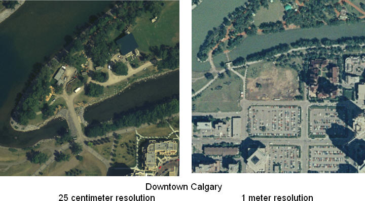
Part of Talisman Energy's problem stemmed from the ever-growing number of images the company needed and the increasing size of those images. An overlay of all of Canada depicted at a one meter image resolution (sufficient to see large objects such as buildings) requires more than a petabyte (1,000 terabytes) of storage capacity. Boosting the image resolution from one meter to 50 centimeters increases the required storage space four-fold. Higher resolutions and backup requirements for these images add multipliers of five to 20 to the final storage tally.
As Talisman Energy expanded exploration into the United States and around the world, storage growth was exceeding the company's ability to manage it. To address these specific storage challenges, Talisman Energy worked with Valtus to become a geospatial SSP.
Geospatial SSPs differentiate themselves from traditional SSPs in two areas: they provide imagery management software and scalable backend storage infrastructures. Geospatial SSPs use software solutions to index and manage imagery data so they can be served to clients. Valtus Imagery Services uses backend storage products from companies like ONStor which allows it to manage petabytes of storage from a single console while maintaining the security and integrity of each client's data.
Imagery Library and Content
To meet Talisman Energy's request, Valtus Imagery Services expanded its imagery library and content in a couple of ways. Valtus was able to offer Talisman Energy access to a shared imagery content library from publicly available resources.
Many nonprofit and government agencies make images publicly available. However, unless companies know which agencies offer images, where they are located, and how to access and update them when new versions of the images become available, this freely available content remains largely inaccessible to most companies that need it. Even when companies know where the images are or can access them, they are often in a format unrecognizable or unusable by corporate applications.
Geospatial SSPs address this situation by continuously gathering and updating these publicly available images and then offering them in formats their clients can use. This service provides two benefits. First, it eliminates the need for clients to dedicate staff and create processes to identify the images on these different sites and monitor them for new images. Second, the format in which images are published by these agencies may not be recognizable to the applications owned by the client. Geospatial SSPs eliminate these concerns by converting the image files into the formats needed.
Geospatial SSPs supplement publicly available images with imagery they acquire. Many images only have a usable life span of 12 to 18 months, especially images of metropolitan areas that are undergoing rapid development or areas that may have recently experienced natural disasters. These changes require a geospatial SSP to regularly update its imagery database. For instance, to satisfy clients like Talisman Energy that have constantly changing imaging demands, Valtus acquires new natural color and infrared digital aerial imagery of large portions of North America on an annual basis. Additionally, Valtus provides more frequent image refreshes for those areas experiencing rapid changes and areas which are of specific interest to clients such as Talisman Energy.
Application Alignment
Talisman Energy encountered a second challenge when trying to manage images internally. There were problems aligning incoming imagery data obtained from contractors with the company's own data. Mark Dumka, a geospatial information specialist with Talisman Energy, found that images arrived in different formats which then had to be translated before they could be used. "We found it difficult to predict the nature and source of the data, which made it challenging to input them into our applications," Dumka said.
To address this need, Valtus delivers images at resolutions to meet specific application requirements. For example, if an application only needs high level views sufficient to identify large buildings or city blocks on an image, then a geospatial SSP may only need to provide images with a 15 meter resolution. However, drilling down to identify smaller details like swimming pools requires images with a resolution of at least one meter, while identifying something as small as a manhole cover calls for images with six inch or even three inch resolutions.
Because geospatial SSPs support multiple clients with similar requirements, they alleviate the need for each company to "reinvent the wheel." Once geospatial SSPs understand an application's specifications, they can solve the application interface problem once, so that their clients' applications can retrieve appropriately sized images from their image database as needed.
Content Consolidation Simplifies Management
The growing investment in infrastructure - computers, databases, networking and storage - needed to support the growing number and size of images was a major concern to Dumka. While Talisman Energy again had expertise in-house to manage it, the company recognized that it was first and foremost an oil and gas exploration company and that these were not core competencies. Migrating from its current environment to one hosted by a geospatial SSP, would require some help. To assist companies like Talisman Energy, Valtus imports existing user image content and then hosts it at its site. This serves to consolidate image access and management and allows users to access images with a common set of tools.
The staff and purpose-built software of geospatial SSPs speed this consolidation process. First, SSP staff inventory existing image files and databases and conduct staff interviews to determine what imaging applications are in use and where they are located. They also may conduct a physical search of the premises to locate image files on CDs, floppies, tapes, USB drives and other types of removable media.
This inventory delivers several cost saving benefits. One such benefit results from identifying duplicate images. Users often have multiple copies of the same image in different locations. By identifying these duplicates, the geospatial SSP can reduce the total number of images that need to be stored. A second cost savings results from reduced licensing fees. Large users sometimes license multiple copies of the same images; eliminating this redundancy reduces overall licensing costs. Image consolidation often results in improved productivity as well.
Once the inventory is complete, the geospatial SSP may next assess which users and applications will benefit from access to what images. Companies often find that prior to centralizing the data, only a small percentage of their employees used an application or accessed specific images. After centralizing these images and making them more accessible, more users do, indeed, use them. This increased productivity often becomes a significant component of the return on investment associated with using a geospatial SSP.
In some cases, companies even find that outsourcing data storage creates a new stream of revenue. If the company "owns" images that other companies would like to use, the geospatial SSP can act as a broker and make those images accessible, for a fee, to other companies.
Infrastructure Design
Talisman Energy hopes to benefit by alleviating the need to keep up with emerging technologies. Dumka said, "Valtus Imagery Services will be able to leverage emerging technologies better and faster that we can ever dream of doing it." In most respects, the facilities and technologies of geospatial SSPs resemble other highly available data centers: redundant sources for cooling, heating and power, as well as high levels of protection from the elements. But geospatial SSPs stand out in two key ways.
The first is in available network bandwidth. Geospatial SSPs need to provide sufficient network bandwidth coming into their facilities to support application requirements and meet user expectations, even during peak usage times. Though this is a two-way street in that users must also have an appropriately sized network pipe coming into their facilities, much of the onus is on the geospatial SSP to appropriately size the network bandwidth for both its site and the client's site and to ensure that redundant connections are in place.
The other advantage is an adaptable, flexible storage infrastructure. Because of the size of the files that higher resolution images create and the increasing frequency with which images are captured, geospatial SSPs must have storage infrastructure that can adapt to these growing storage requirements.
Talisman Energy (Calgary, Alberta) is a large independent Canadian oil and gas exploration company that relies on map images to support its Canadian and international exploration operations. In 2000, Talisman Energy began to experience difficulty in acquiring all the images it needed to operate efficiently. Talisman Energy acquired maps of Alberta from Valtus Imagery Services, but the company's need for imagery continued to grow, and soon data management and storage challenges cropped up.
Part of Talisman Energy's problem stemmed from the ever-growing number of images the company needed and the increasing size of those images. An overlay of all of Canada depicted at a one meter image resolution (sufficient to see large objects such as buildings) requires more than a petabyte (1,000 terabytes) of storage capacity. Boosting the image resolution from one meter to 50 centimeters increases the required storage space four-fold. Higher resolutions and backup requirements for these images add multipliers of five to 20 to the final storage tally.
 |
As Talisman Energy expanded exploration into the United States and around the world, storage growth was exceeding the company's ability to manage it. To address these specific storage challenges, Talisman Energy worked with Valtus to become a geospatial SSP.
Geospatial SSPs differentiate themselves from traditional SSPs in two areas: they provide imagery management software and scalable backend storage infrastructures. Geospatial SSPs use software solutions to index and manage imagery data so they can be served to clients. Valtus Imagery Services uses backend storage products from companies like ONStor which allows it to manage petabytes of storage from a single console while maintaining the security and integrity of each client's data.
Imagery Library and Content
To meet Talisman Energy's request, Valtus Imagery Services expanded its imagery library and content in a couple of ways. Valtus was able to offer Talisman Energy access to a shared imagery content library from publicly available resources.
Many nonprofit and government agencies make images publicly available. However, unless companies know which agencies offer images, where they are located, and how to access and update them when new versions of the images become available, this freely available content remains largely inaccessible to most companies that need it. Even when companies know where the images are or can access them, they are often in a format unrecognizable or unusable by corporate applications.
Geospatial SSPs address this situation by continuously gathering and updating these publicly available images and then offering them in formats their clients can use. This service provides two benefits. First, it eliminates the need for clients to dedicate staff and create processes to identify the images on these different sites and monitor them for new images. Second, the format in which images are published by these agencies may not be recognizable to the applications owned by the client. Geospatial SSPs eliminate these concerns by converting the image files into the formats needed.
Geospatial SSPs supplement publicly available images with imagery they acquire. Many images only have a usable life span of 12 to 18 months, especially images of metropolitan areas that are undergoing rapid development or areas that may have recently experienced natural disasters. These changes require a geospatial SSP to regularly update its imagery database. For instance, to satisfy clients like Talisman Energy that have constantly changing imaging demands, Valtus acquires new natural color and infrared digital aerial imagery of large portions of North America on an annual basis. Additionally, Valtus provides more frequent image refreshes for those areas experiencing rapid changes and areas which are of specific interest to clients such as Talisman Energy.
Application Alignment
Talisman Energy encountered a second challenge when trying to manage images internally. There were problems aligning incoming imagery data obtained from contractors with the company's own data. Mark Dumka, a geospatial information specialist with Talisman Energy, found that images arrived in different formats which then had to be translated before they could be used. "We found it difficult to predict the nature and source of the data, which made it challenging to input them into our applications," Dumka said.
To address this need, Valtus delivers images at resolutions to meet specific application requirements. For example, if an application only needs high level views sufficient to identify large buildings or city blocks on an image, then a geospatial SSP may only need to provide images with a 15 meter resolution. However, drilling down to identify smaller details like swimming pools requires images with a resolution of at least one meter, while identifying something as small as a manhole cover calls for images with six inch or even three inch resolutions.
Because geospatial SSPs support multiple clients with similar requirements, they alleviate the need for each company to "reinvent the wheel." Once geospatial SSPs understand an application's specifications, they can solve the application interface problem once, so that their clients' applications can retrieve appropriately sized images from their image database as needed.
Content Consolidation Simplifies Management
The growing investment in infrastructure - computers, databases, networking and storage - needed to support the growing number and size of images was a major concern to Dumka. While Talisman Energy again had expertise in-house to manage it, the company recognized that it was first and foremost an oil and gas exploration company and that these were not core competencies. Migrating from its current environment to one hosted by a geospatial SSP, would require some help. To assist companies like Talisman Energy, Valtus imports existing user image content and then hosts it at its site. This serves to consolidate image access and management and allows users to access images with a common set of tools.
The staff and purpose-built software of geospatial SSPs speed this consolidation process. First, SSP staff inventory existing image files and databases and conduct staff interviews to determine what imaging applications are in use and where they are located. They also may conduct a physical search of the premises to locate image files on CDs, floppies, tapes, USB drives and other types of removable media.
This inventory delivers several cost saving benefits. One such benefit results from identifying duplicate images. Users often have multiple copies of the same image in different locations. By identifying these duplicates, the geospatial SSP can reduce the total number of images that need to be stored. A second cost savings results from reduced licensing fees. Large users sometimes license multiple copies of the same images; eliminating this redundancy reduces overall licensing costs. Image consolidation often results in improved productivity as well.
Once the inventory is complete, the geospatial SSP may next assess which users and applications will benefit from access to what images. Companies often find that prior to centralizing the data, only a small percentage of their employees used an application or accessed specific images. After centralizing these images and making them more accessible, more users do, indeed, use them. This increased productivity often becomes a significant component of the return on investment associated with using a geospatial SSP.
In some cases, companies even find that outsourcing data storage creates a new stream of revenue. If the company "owns" images that other companies would like to use, the geospatial SSP can act as a broker and make those images accessible, for a fee, to other companies.
Infrastructure Design
Talisman Energy hopes to benefit by alleviating the need to keep up with emerging technologies. Dumka said, "Valtus Imagery Services will be able to leverage emerging technologies better and faster that we can ever dream of doing it." In most respects, the facilities and technologies of geospatial SSPs resemble other highly available data centers: redundant sources for cooling, heating and power, as well as high levels of protection from the elements. But geospatial SSPs stand out in two key ways.
The first is in available network bandwidth. Geospatial SSPs need to provide sufficient network bandwidth coming into their facilities to support application requirements and meet user expectations, even during peak usage times. Though this is a two-way street in that users must also have an appropriately sized network pipe coming into their facilities, much of the onus is on the geospatial SSP to appropriately size the network bandwidth for both its site and the client's site and to ensure that redundant connections are in place.
The other advantage is an adaptable, flexible storage infrastructure. Because of the size of the files that higher resolution images create and the increasing frequency with which images are captured, geospatial SSPs must have storage infrastructure that can adapt to these growing storage requirements.
From Our Homepage
Saying Farewell to an Amazing Journey
Communicating with Maps
Is There a GIS Career Ladder?
What does it mean to be geospatially smart? Series
Ways Real Estate and Property Developers Utilize Melissa GeoData for Data-Driven Decisions
Unlocking Value From Daily Satellite Imagery and Insights
Maximizing the Value of Your Address Data with Geo Addressing
How Indoor Mapping Enhances the Security of Smart Buildings
Look Ahead: AI, Location Intelligence and Efficiency
Collaboration Takes on Sea Level Rise & Dynamic Technology Environments
Brownies for Brownfields
Has Everything Been Mapped Already?
How Is Data Literacy Changing in an Artificial Intelligence Landscape
Portfolios for GIS Professionals: More Than Just Maps
How to Create a Distance Matrix in QGIS - A Step-by-Step Guide
7 Ideas for Bringing GIS into the K-12 Classroom
The Geography of Movement