Ed. Note:
As you read through this article about Immersive Media, you should
be
aware that they have used the technology described to capture 23 out of
a
planned 25 cities in the U.S. If you are doing retail expansion, or
other activities that could benefit from this type of data, you might
want to explore the company's web
site and see if one of these cities fits your
needs. The data feeds from all 11
cameras are stitched together into a geo-referenced 360 degree data
stream, allowing you to measure, add to a map, etc.
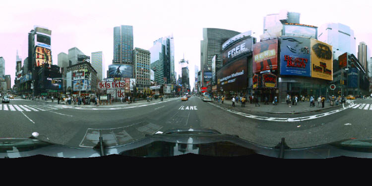
Immersive Media Corp. (IMC) is an advanced digital video imaging company. Founded in 1995, IMC’s spherical video technology captures imagery in all directions simultaneously - a complete 360 degree, georeferenced, immersive video that provides a dataset for critical decisions and mapping.
GeoImmersive video places you, the viewer, in the middle of the environment and within context so you do not miss a thing. The omni-directional nature of the video allows the user to look at the same feature, location or object from all angles – front, back, side and top. The ArcGIS extension enables users to embed GeoImmersive imagery for access at specific locations and to be able to navigate through the environment.
How it works
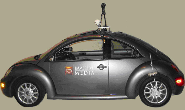
The portable Telemmersion Camera with eleven lenses can be mounted easily to a variety of surfaces, including airborne and land vehicles, or can be hand-held.
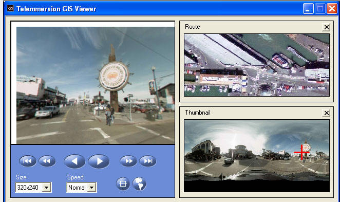
Immersive imagery can be displayed live or recorded and presented on a number of different viewing devices ranging from monitors to a head mounted display. Up to five types of metadata can be simultaneously recorded with the immersive video. The IMC post-production software stitches together the footage providing unobstructed, omni-directional video. Audiences can navigate through the video via simple VCR-style controls and be in charge of what they see within the environment. A demo is available.
GeoImmersive Imagery Database
GeoImmersive video is available for each of the largest cities in the US and Canada including all major arteries, the downtown core and key attractions. International data collection is expanding across Europe and the Pacific Rim. The georeferenced video enables users to experience a terrestrial view and gives a picture as well as necessary GPS information. Exceeding the limitations of traditional aerial mapping which produces an abstract two dimensional map, GeoImmersive video also provides an “on the ground” experience that transcends the capabilities of computer modeling by providing spherical video that captures reality.
The data can be licensed from IMC. Capture and post-production services are also available either direct through IMC or via a Certified Immersive Service Partner.
Immersive Media Corp. (IMC) is an advanced digital video imaging company. Founded in 1995, IMC’s spherical video technology captures imagery in all directions simultaneously - a complete 360 degree, georeferenced, immersive video that provides a dataset for critical decisions and mapping.
GeoImmersive video places you, the viewer, in the middle of the environment and within context so you do not miss a thing. The omni-directional nature of the video allows the user to look at the same feature, location or object from all angles – front, back, side and top. The ArcGIS extension enables users to embed GeoImmersive imagery for access at specific locations and to be able to navigate through the environment.
 |
How it works
The portable Telemmersion Camera with eleven lenses can be mounted easily to a variety of surfaces, including airborne and land vehicles, or can be hand-held.
 |
Immersive imagery can be displayed live or recorded and presented on a number of different viewing devices ranging from monitors to a head mounted display. Up to five types of metadata can be simultaneously recorded with the immersive video. The IMC post-production software stitches together the footage providing unobstructed, omni-directional video. Audiences can navigate through the video via simple VCR-style controls and be in charge of what they see within the environment. A demo is available.
GeoImmersive Imagery Database
GeoImmersive video is available for each of the largest cities in the US and Canada including all major arteries, the downtown core and key attractions. International data collection is expanding across Europe and the Pacific Rim. The georeferenced video enables users to experience a terrestrial view and gives a picture as well as necessary GPS information. Exceeding the limitations of traditional aerial mapping which produces an abstract two dimensional map, GeoImmersive video also provides an “on the ground” experience that transcends the capabilities of computer modeling by providing spherical video that captures reality.
 |
The data can be licensed from IMC. Capture and post-production services are also available either direct through IMC or via a Certified Immersive Service Partner.
From Our Homepage
Saying Farewell to an Amazing Journey
Communicating with Maps
Is There a GIS Career Ladder?
What does it mean to be geospatially smart? Series
Ways Real Estate and Property Developers Utilize Melissa GeoData for Data-Driven Decisions
Unlocking Value From Daily Satellite Imagery and Insights
Maximizing the Value of Your Address Data with Geo Addressing
How Indoor Mapping Enhances the Security of Smart Buildings
Look Ahead: AI, Location Intelligence and Efficiency
Collaboration Takes on Sea Level Rise & Dynamic Technology Environments
Brownies for Brownfields
Has Everything Been Mapped Already?
How Is Data Literacy Changing in an Artificial Intelligence Landscape
Portfolios for GIS Professionals: More Than Just Maps
How to Create a Distance Matrix in QGIS - A Step-by-Step Guide
7 Ideas for Bringing GIS into the K-12 Classroom
The Geography of Movement