Location Intelligence can be
added
to simple, non-spatial data in three fundamental ways: 1) a data
record can be converted to a spatial data record by adding location;
2) the tabular attributes of a spatial data record can be augmented,
amplified, and updated; and 3) a spatial data record can be enhanced by
adding locational references and links to other spatial
databases.These Location Intelligence elements can be termed:
Simple Location, Attribute Enhancement, and Spatial Processing.
For example, most new cell phones have GPS capability (Simple Location).Normally, the location of a specific phone is unimportant, but that is subject to immediate change when a user dials 911 (Attribute Enhancement).More than half of all 911 calls are now made from cell phones.However, the lat/lon of a cell call is meaningless unless it is connected to other spatial information.In the case of 911 calls, Spatial Processing is required to connect the lat/lon of the 911 calls to spatial database of first responder polygons to direct the call to the proper responding agency (fire, police, EMT).Spatial Processing is the primary function of GIS and it is the simple GIS operations such as point-in-polygon, nearest, or distance to closest feature that add Location Intelligence to separate databases within a system.
This article illustrates the addition of the three elements of Location Intelligence in the context of enhanced "psychographic" data into the process of site location modeling.As databases become more complete and grow in complexity, Location Intelligence will become increasingly important as a primary way to analyze, model, and derive value from simple non-spatial records.
Simple Location: The silver bullet for market research, target marketing, and site location modeling has always been comprehensive data at the level of the individual or household.Household records usually contain an address that can be geocoded (Simple Location) for further spatial processing and analysis.Some sources suggest that 70%-80% of all data records can be tied to some locational information (especially an address).Robust geocoding engines, improved geo-coding data (street networks and parcel information), GPS, and other forms of technology and data gathering techniques are all converging to increase the number of records with simple location.
These richer databases and advances in data mining and retrieval technology have shifted the focus from basic demographic information at coarse spatial levels such as ZIP codes to more focused "psychographic" segmentation models in smaller census geographies like block groups.Psychographics is based on a sound theory that acknowledges that two side-by-side households may be very similar in basic demographics, but quite different in what they read, how they spend their income, and what they buy.They have different "lifestyles".The details are extremely informative, but the implementation into practical applications is more difficult.The general approach has been to roll up the individual data into 40 or 50 "clusters" with cute names like "Organic Volvos" or "Pickups and Trailer Parks" that immediately degrade the individuality of the data. Many segmentation vendors further weaken the data by rolling it up to the census block group level based on the dominant cluster in the polygon.
Attribute Enhancement: Advanced data handling techniques, however, now make it possible to extend the psychographic model down to the individual household and to process all information at the household level.Every household should be a separate "cluster".Each household can be scored with a probability of purchase for a specific product and assigned a potential dollar figure to estimate sales.Household level clustering and purchase probability are examples of Attribute Enhancement.
Proxix Solutions, Inc.of Palm Harbor, Florida has developed spatial data processing routines to analyze, profile, and score individual households.Proxix maintains a national database of over 110 million individual household records.The existing customers of a client are matched to this database based on name and/or address.Each customer record is enhanced with the demographic data from the Proxix household file (e.g., income level, length of residence, age, marital status).Proxix applies as variety of data mining and statistical techniques to examine multivariate, and interaction effects relationships among variables.This determines the best unique set of variables for given client and its product lines.This customized analysis is designed to provide the best "fit" among the variables at the household level.
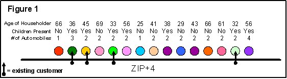
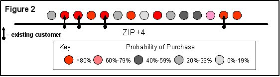
Combinations of variables are then used to create "look-alike profiles"; unique composite descriptions of existing customers as a basis for targeting potential customers. Look-alike profiles can be customized for different product lines within a company because the customer base often differs from product to product.Look-alike profiles are used to generate a scoring methodology (purchase probability times the expected dollar value of each household) to identify expected sales in any geography and "best customer prospects" around an existing or future site.Every household in a given geography (e.g., ZIP+4) may exhibit a different "profile" or demographic and socioeconomic characteristics (Figure 1) and every household in a block group may have a different "Probability of Purchase" because each household is unique (Figure 2).
Spatial Processing: Furthermore, each household's score is not fixed, but must re-calibrated on-the-fly as conditions on the ground change.For example, a household's potential to purchase specialty ice cream will increase if a new ice cream stores opens near them.Additional location intelligence is added when each spatial record in the household database is further processed with the distance to existing stores, competitors, and traffic generators.Spatial processing also adds the geographic area within the United States (regionality), residential and daytime population density classes and corporate specific variables (e.g., marketing dollars spent in a given area, product life cycle, intensity of competition in a geography).
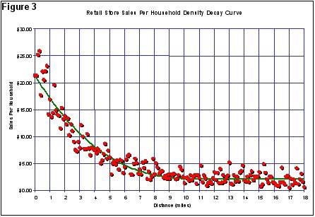
The distance from a given consumer household to a proposed site and to competitors is always a critical variable in any site location model and is a fundamental reason for the importance of GIS technology in the process.The exact parameters of these curves can only be determined by an analysis of existing, granular customer data.
In addition, empirical evidence shows that the parameters vary significantly and consistently with underlying household (residential and daytime) density classes (Figure 3).Proxix has developed the technology to calculate the distance to all household points within a limiting distance for a proposed site on-the-fly and to apply specific distance decay curves based on density class.The "potential" of any given household is its individual cluster score factored by a distance decay curve to a proposed site, sister stores, and competitors.Furthermore, this potential is also adjusted by distance to traffic generators that may pull prospective customers past the site.A pure psychographic approach generally ignores both straight line and drive time distances from consumers to these important points.In other words, they lack location intelligence.
In conclusion, all three aspects of Location Intelligence greatly improve the accuracy, utility, and extensibility of databases.They add information and intelligence to data.Individual household data enhanced with Location Intelligence is critical for robust site location modeling.Analysis can be based on the attribute enhancement and spatial processing of individual geocoded households.Every household has an estimated potential dollar value to a new site.As the potential site is moved around, the values change to reflect distance to the site and to competitors and sister stores.The error band of sales forecasts is reduced and the calculation of sales diversion from sister stores is greatly improved.
For example, most new cell phones have GPS capability (Simple Location).Normally, the location of a specific phone is unimportant, but that is subject to immediate change when a user dials 911 (Attribute Enhancement).More than half of all 911 calls are now made from cell phones.However, the lat/lon of a cell call is meaningless unless it is connected to other spatial information.In the case of 911 calls, Spatial Processing is required to connect the lat/lon of the 911 calls to spatial database of first responder polygons to direct the call to the proper responding agency (fire, police, EMT).Spatial Processing is the primary function of GIS and it is the simple GIS operations such as point-in-polygon, nearest, or distance to closest feature that add Location Intelligence to separate databases within a system.
This article illustrates the addition of the three elements of Location Intelligence in the context of enhanced "psychographic" data into the process of site location modeling.As databases become more complete and grow in complexity, Location Intelligence will become increasingly important as a primary way to analyze, model, and derive value from simple non-spatial records.
Simple Location: The silver bullet for market research, target marketing, and site location modeling has always been comprehensive data at the level of the individual or household.Household records usually contain an address that can be geocoded (Simple Location) for further spatial processing and analysis.Some sources suggest that 70%-80% of all data records can be tied to some locational information (especially an address).Robust geocoding engines, improved geo-coding data (street networks and parcel information), GPS, and other forms of technology and data gathering techniques are all converging to increase the number of records with simple location.
These richer databases and advances in data mining and retrieval technology have shifted the focus from basic demographic information at coarse spatial levels such as ZIP codes to more focused "psychographic" segmentation models in smaller census geographies like block groups.Psychographics is based on a sound theory that acknowledges that two side-by-side households may be very similar in basic demographics, but quite different in what they read, how they spend their income, and what they buy.They have different "lifestyles".The details are extremely informative, but the implementation into practical applications is more difficult.The general approach has been to roll up the individual data into 40 or 50 "clusters" with cute names like "Organic Volvos" or "Pickups and Trailer Parks" that immediately degrade the individuality of the data. Many segmentation vendors further weaken the data by rolling it up to the census block group level based on the dominant cluster in the polygon.
Attribute Enhancement: Advanced data handling techniques, however, now make it possible to extend the psychographic model down to the individual household and to process all information at the household level.Every household should be a separate "cluster".Each household can be scored with a probability of purchase for a specific product and assigned a potential dollar figure to estimate sales.Household level clustering and purchase probability are examples of Attribute Enhancement.
Proxix Solutions, Inc.of Palm Harbor, Florida has developed spatial data processing routines to analyze, profile, and score individual households.Proxix maintains a national database of over 110 million individual household records.The existing customers of a client are matched to this database based on name and/or address.Each customer record is enhanced with the demographic data from the Proxix household file (e.g., income level, length of residence, age, marital status).Proxix applies as variety of data mining and statistical techniques to examine multivariate, and interaction effects relationships among variables.This determines the best unique set of variables for given client and its product lines.This customized analysis is designed to provide the best "fit" among the variables at the household level.
Combinations of variables are then used to create "look-alike profiles"; unique composite descriptions of existing customers as a basis for targeting potential customers. Look-alike profiles can be customized for different product lines within a company because the customer base often differs from product to product.Look-alike profiles are used to generate a scoring methodology (purchase probability times the expected dollar value of each household) to identify expected sales in any geography and "best customer prospects" around an existing or future site.Every household in a given geography (e.g., ZIP+4) may exhibit a different "profile" or demographic and socioeconomic characteristics (Figure 1) and every household in a block group may have a different "Probability of Purchase" because each household is unique (Figure 2).
 |
 |
Spatial Processing: Furthermore, each household's score is not fixed, but must re-calibrated on-the-fly as conditions on the ground change.For example, a household's potential to purchase specialty ice cream will increase if a new ice cream stores opens near them.Additional location intelligence is added when each spatial record in the household database is further processed with the distance to existing stores, competitors, and traffic generators.Spatial processing also adds the geographic area within the United States (regionality), residential and daytime population density classes and corporate specific variables (e.g., marketing dollars spent in a given area, product life cycle, intensity of competition in a geography).
The distance from a given consumer household to a proposed site and to competitors is always a critical variable in any site location model and is a fundamental reason for the importance of GIS technology in the process.The exact parameters of these curves can only be determined by an analysis of existing, granular customer data.
In addition, empirical evidence shows that the parameters vary significantly and consistently with underlying household (residential and daytime) density classes (Figure 3).Proxix has developed the technology to calculate the distance to all household points within a limiting distance for a proposed site on-the-fly and to apply specific distance decay curves based on density class.The "potential" of any given household is its individual cluster score factored by a distance decay curve to a proposed site, sister stores, and competitors.Furthermore, this potential is also adjusted by distance to traffic generators that may pull prospective customers past the site.A pure psychographic approach generally ignores both straight line and drive time distances from consumers to these important points.In other words, they lack location intelligence.
 |
In conclusion, all three aspects of Location Intelligence greatly improve the accuracy, utility, and extensibility of databases.They add information and intelligence to data.Individual household data enhanced with Location Intelligence is critical for robust site location modeling.Analysis can be based on the attribute enhancement and spatial processing of individual geocoded households.Every household has an estimated potential dollar value to a new site.As the potential site is moved around, the values change to reflect distance to the site and to competitors and sister stores.The error band of sales forecasts is reduced and the calculation of sales diversion from sister stores is greatly improved.
From Our Homepage
Saying Farewell to an Amazing Journey
Communicating with Maps
Is There a GIS Career Ladder?
What does it mean to be geospatially smart? Series
Ways Real Estate and Property Developers Utilize Melissa GeoData for Data-Driven Decisions
Unlocking Value From Daily Satellite Imagery and Insights
Maximizing the Value of Your Address Data with Geo Addressing
How Indoor Mapping Enhances the Security of Smart Buildings
Look Ahead: AI, Location Intelligence and Efficiency
Collaboration Takes on Sea Level Rise & Dynamic Technology Environments
Brownies for Brownfields
Has Everything Been Mapped Already?
How Is Data Literacy Changing in an Artificial Intelligence Landscape
Portfolios for GIS Professionals: More Than Just Maps
How to Create a Distance Matrix in QGIS - A Step-by-Step Guide
7 Ideas for Bringing GIS into the K-12 Classroom
The Geography of Movement