In our last article
we talked about how location
intelligence, the merging of GIS with business intelligence, can
provide
strategic advantage to companies looking to do business in emerging
markets
like China, Russia and India.Through map visualization, spatial
analysis and
data enhancement, location intelligence can bolster critical business
activities like site selection and competitor intelligence.
A first step toward location intelligence is acquiring the right set of spatial data to include in your spatial data warehouse. The data gathered will form the basis for all subsequent location intelligence analysis and reporting, so many factors are important to consider: quality, vintage and coverage to name a few.This series of articles is presented as a kind of road map for getting started.This article begins with a focus on China, specifically.
The International Organization for Standardization (ISO) has developed a helpful categorization of spatial data which should be the basis of a checklist for any spatial data warehouse.The goal of the ISO, a non-governmental organization network of national standards instituted in 146 counties, is to promote international standards (www.iso.org ), including spatial data.The ISO/TC 211 (www.isotc211.org) is responsible for the standardization of digital geographic information/geomatics data and its methods.As part of this effort, they have categorized 19 different spatial topics.Building on the ISO work, the State of Minnesota has created and customized their own list, called the Minnesota Geospatial Data Categories.
For Figure 1, we have used the Minnesota document to build a short list of categories most critical to business needs.For each category, example map features are listed, and for China specifically, a data source has been identified and ranked for overall usefulness in location intelligence.
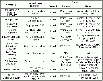
** EOS Data Gateway
*** USGS
These ten categories will help frame the discussion below.
Administrative and Political Boundaries
The political boundaries layer is perhaps the most important for the business-focused spatial data warehouse.This foundational layer provides a context for other data sets, and can be overlaid with internal business data, combined with other map feature layers, such as road networks, more specific to the analysis being done; also the units of this layer often match the aggregation units used by the national census agencies for tallying and tracking statistics like population, business activity, and income - important measures for analysis.
As readers may be unfamiliar with China's political units and hierarchy, a good way of getting familiar is by way of a short comparison with the hierarchy of the United States.Fortunately, there are quite a few similarities, but with some distinctions that are important to know.A graphical comparison of the hierarchies is presented in Figure 2.
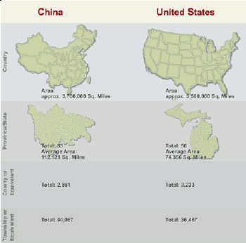
The primary political boundary of China is the Province, of which there are 33 (this includes 11 province-level divisions); these compare with the 50 States of the US.Examples of the 11 province-level divisions include Beijing, Hong Kong, and Inner Mongolia.Taiwan is a disputed province and has been considered by some to be the 34th province.In the US, we also have areas considered state equivalents by the US Census: Washington DC, Puerto Rico, and the Virgin Islands are a few of these areas.
Next in the China data hierarchy are Prefectures, Counties, and then Townships.For prefectures there is really no US equivalent, and as not much data is available for these units we will not focus on them. Counties are the next level of administration in China, and are roughly similar to the counties we have in the US.China also has some county equivalents that are cities, or another type of independent unit, not unlike the independent cities found in states like Virginia.The sub-divisions of counties in China are the township level divisions.These divisions are similar to the Minor Civil Division (MCD) structure in the US.
An extremely useful unit for location analysis in the United States is the Census Tract (because they were established to provide a semi-permanent geography entity for the Census, tracts are a much better choice than zip codes).The rough equivalent in China is the village, which does not possess much political pull, but serves more for census and postal routing purposes.However, these units do have actual neighborhood and community divisions outlined within them.
Demographics
Falling under the Demographic category are population statistics, measures closely tied to administrative units in the US and China because of the national censuses.The US Census is conducted every ten years at the start of every new decade (e.g., 1980, 1990 and 2000) and began in 1790.The People's Republic of China has conducted five national censuses since 1949 when it changed from The Republic of China.The first official census was taken in 1953 and was followed up in 1964, 1982, 1990, and most recently in 2000.
Other Data Categories
One of the best sources for a broad range of China data, including some data free of charge, is the China Data Center of the University of Michigan.Here you can find political boundaries, population statistics, business information, and more, most of which is aggregated to the Province level, but available for Counties and Townships as well.Expect to do some work, though, navigating to the data sets, downloading, and then formatting the data to your needs.
Unfortunately, for two data categories, Facilities, Buildings and Structures and the Land Use Planning, not much was found in the public domain.The China Data Center does provide, for a fee, a Business Directory of 250,000 business location information for the former, but for Land Use Planning, nothing was found on the China Data Center website or elsewhere.
For Transportation and Utilities & Communications, the USGS has a source available on a CD-ROM; another source is http://gisdatadepot.com.For more up to date data, commercial sources should be sought out.
We have offered a brief overview of China data, delineating the political boundaries of China, and highlighting select sources that IDV Solutions has found helpful in our project work.In Figure 3, a recent web application project is shown in which public domain data was used for geocoding of auto supplier locations, and then these locations were overlaid on China mapping provided through Microsoft's MapPoint Web Service.
China data is a topic of great interest to many business and organizations, and new data sources become available all the time.You are invited to weigh in below ("Comments" section) with sources of China data you may have found helpful in your research and analysis.
The author wishes to thank Joe Gilberg for the research he provided for this article.
A first step toward location intelligence is acquiring the right set of spatial data to include in your spatial data warehouse. The data gathered will form the basis for all subsequent location intelligence analysis and reporting, so many factors are important to consider: quality, vintage and coverage to name a few.This series of articles is presented as a kind of road map for getting started.This article begins with a focus on China, specifically.
The International Organization for Standardization (ISO) has developed a helpful categorization of spatial data which should be the basis of a checklist for any spatial data warehouse.The goal of the ISO, a non-governmental organization network of national standards instituted in 146 counties, is to promote international standards (www.iso.org ), including spatial data.The ISO/TC 211 (www.isotc211.org) is responsible for the standardization of digital geographic information/geomatics data and its methods.As part of this effort, they have categorized 19 different spatial topics.Building on the ISO work, the State of Minnesota has created and customized their own list, called the Minnesota Geospatial Data Categories.
For Figure 1, we have used the Minnesota document to build a short list of categories most critical to business needs.For each category, example map features are listed, and for China specifically, a data source has been identified and ranked for overall usefulness in location intelligence.
Figure 1.Categories of
spatial data for business along with
general information on select, free sources for China data.Click
image for larger view.
*
China
Data Center ** EOS Data Gateway
*** USGS
These ten categories will help frame the discussion below.
Administrative and Political Boundaries
The political boundaries layer is perhaps the most important for the business-focused spatial data warehouse.This foundational layer provides a context for other data sets, and can be overlaid with internal business data, combined with other map feature layers, such as road networks, more specific to the analysis being done; also the units of this layer often match the aggregation units used by the national census agencies for tallying and tracking statistics like population, business activity, and income - important measures for analysis.
As readers may be unfamiliar with China's political units and hierarchy, a good way of getting familiar is by way of a short comparison with the hierarchy of the United States.Fortunately, there are quite a few similarities, but with some distinctions that are important to know.A graphical comparison of the hierarchies is presented in Figure 2.

Figure 2.Political
Boundaries Overview: China and the
United States.Click image for larger view.
The primary political boundary of China is the Province, of which there are 33 (this includes 11 province-level divisions); these compare with the 50 States of the US.Examples of the 11 province-level divisions include Beijing, Hong Kong, and Inner Mongolia.Taiwan is a disputed province and has been considered by some to be the 34th province.In the US, we also have areas considered state equivalents by the US Census: Washington DC, Puerto Rico, and the Virgin Islands are a few of these areas.
Next in the China data hierarchy are Prefectures, Counties, and then Townships.For prefectures there is really no US equivalent, and as not much data is available for these units we will not focus on them. Counties are the next level of administration in China, and are roughly similar to the counties we have in the US.China also has some county equivalents that are cities, or another type of independent unit, not unlike the independent cities found in states like Virginia.The sub-divisions of counties in China are the township level divisions.These divisions are similar to the Minor Civil Division (MCD) structure in the US.
An extremely useful unit for location analysis in the United States is the Census Tract (because they were established to provide a semi-permanent geography entity for the Census, tracts are a much better choice than zip codes).The rough equivalent in China is the village, which does not possess much political pull, but serves more for census and postal routing purposes.However, these units do have actual neighborhood and community divisions outlined within them.
Demographics
Falling under the Demographic category are population statistics, measures closely tied to administrative units in the US and China because of the national censuses.The US Census is conducted every ten years at the start of every new decade (e.g., 1980, 1990 and 2000) and began in 1790.The People's Republic of China has conducted five national censuses since 1949 when it changed from The Republic of China.The first official census was taken in 1953 and was followed up in 1964, 1982, 1990, and most recently in 2000.
Other Data Categories
One of the best sources for a broad range of China data, including some data free of charge, is the China Data Center of the University of Michigan.Here you can find political boundaries, population statistics, business information, and more, most of which is aggregated to the Province level, but available for Counties and Townships as well.Expect to do some work, though, navigating to the data sets, downloading, and then formatting the data to your needs.
Unfortunately, for two data categories, Facilities, Buildings and Structures and the Land Use Planning, not much was found in the public domain.The China Data Center does provide, for a fee, a Business Directory of 250,000 business location information for the former, but for Land Use Planning, nothing was found on the China Data Center website or elsewhere.
For Transportation and Utilities & Communications, the USGS has a source available on a CD-ROM; another source is http://gisdatadepot.com.For more up to date data, commercial sources should be sought out.
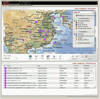
We have offered a brief overview of China data, delineating the political boundaries of China, and highlighting select sources that IDV Solutions has found helpful in our project work.In Figure 3, a recent web application project is shown in which public domain data was used for geocoding of auto supplier locations, and then these locations were overlaid on China mapping provided through Microsoft's MapPoint Web Service.

Figure 3.Auto
suppliers of China overlaid on
MapPoint-provided geography.Click image for larger view.
China data is a topic of great interest to many business and organizations, and new data sources become available all the time.You are invited to weigh in below ("Comments" section) with sources of China data you may have found helpful in your research and analysis.
The author wishes to thank Joe Gilberg for the research he provided for this article.
From Our Homepage
Saying Farewell to an Amazing Journey
Communicating with Maps
Is There a GIS Career Ladder?
What does it mean to be geospatially smart? Series
Ways Real Estate and Property Developers Utilize Melissa GeoData for Data-Driven Decisions
Unlocking Value From Daily Satellite Imagery and Insights
Maximizing the Value of Your Address Data with Geo Addressing
How Indoor Mapping Enhances the Security of Smart Buildings
Look Ahead: AI, Location Intelligence and Efficiency
Collaboration Takes on Sea Level Rise & Dynamic Technology Environments
Brownies for Brownfields
Has Everything Been Mapped Already?
How Is Data Literacy Changing in an Artificial Intelligence Landscape
Portfolios for GIS Professionals: More Than Just Maps
How to Create a Distance Matrix in QGIS - A Step-by-Step Guide
7 Ideas for Bringing GIS into the K-12 Classroom
The Geography of Movement