Moderated by Jeff Harrison and John Moeller of the USGIF and governmental representatives, more than 30 companies showed how GEOINT standards can help connect data and technologies through geospatial web services.Battling a short preparation time, untested hardware settings and shaky wireless internet connections, all the demonstration cycles went forward almost without a hitch.Standards from organizations such as the World Wide Web Consortium (W3C), International Organization for Standardization (ISO), the Open Geospatial Consortium (OGC) and others formed the foundation for interoperability in the demonstration.
Showcased technologies included a GEOINT portal from BEA Systems, GEOINT discovery services from Compusult, imagery access services from ITT Industries and CubeWerx, automated feature analysis from Visual Learning Systems running on ESRI's ArcGIS, 3D visualization and planning services from Skyline and GeoTango, image analysis tools from IDELIX, Intergraph and BAE Systems, new transactional Web Feature Service (WFS-T) extensions for ArcGIS from Northrop Grumman Information Technology, TASC and Ionic Enterprise, sensor planning services from Analytical Graphics, interactive modeling services from SAIC, and many more.In addition, the demo integrated an incredible amount of information and capabilities from commercial imagery sources including Earth Satellite Corporation, Digital Globe, ORBIMAGE, Space Imaging, and RADARSAT, online services from Custom Weather, MapWerks, and MapShed Australia and architectural components from Questerra, IBM and many others.
The geospatial
interoperability display did not stop at the
USGIF demonstration.Many of the companies involved in the demo were
also
showcasing the technology in their own booths.Using a
new architectural approach based on commonly accessible
data and Common Service Frameworks supported by widely accepted
standards,
participating companies showed the rapidly growing capability that now
exists
to meet the need to share geospatial intelligence data and information,
and to
provide technology integration across multiple delivery platforms.For
example,
Northrop Grumman Information Technology and TASC displayed a
live demo
that used GEOINT data and OGC Web Feature Services to highlight how
GEOINT
Services can be rapidly deployed and integrated with existing
geospatial enterprise
capabilities.
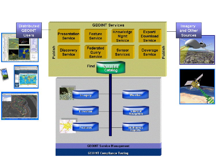
Schema of the interoperability display.Click image for larger view.
A few years ago a demo of this magnitude would have required many months of preparation.In this event, only 20 days were needed to pull all of this together.The fact that 30 companies and a dozen or so products could be organized together to a single coherent scenario, in such a short time, is a testimony that geospatial interoperability is finally here."The demo really showed how the techniques and cultures of the Internet can be applied to the challenges facing the GEOINT community," said Jeff Harrison, who anchored the presentation, "We're not done though and need to make sure we work together to rapidly bring this capability forward in our overall GEOINT approach."