By using geo-spatial technology to present a visual representation of current claims, FFB can quickly locate areas with the highest concentration of claims and deploy the necessary resources, such as adjustors, claims agents and insurance agents.For instance, after a natural disaster, FFB uses geo-spatial technology from MapInfo Corporation to predict possible (and then to display actual) losses by overlaying event information, such as hurricane track and wind speed against its policyholder points.By more efficiently deploying its resources, FFB is able to streamline the claims process and more quickly assist hurricane victims who have lost their homes, cars, businesses and personal assets.
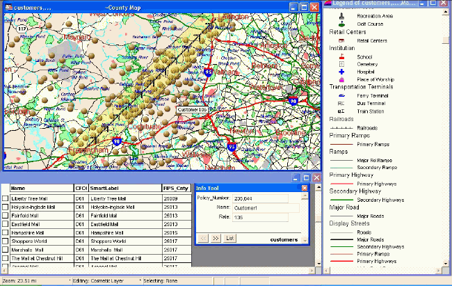
Image depicts commercial
policies within a hurricane path to determine potential
PML (Probable Maximum
Loss).Includes rating information, as well as other
pertinent information.
(Click image for larger view.)
"When catastrophic events like Charley and Frances come along, the application of GIS to solving the questions of who, where and how many is critical," says Steve Wallace, FFB's senior strategic planner."We analyze the storm track and damaging wind fields versus our insured locations that are geocoded to predict the number of claims, and then plot out the actual locations of losses when they are reported.This helps claims managers assign manpower, as well as helping individual adjusters plan their daily agenda to cover losses in proximity to each other."
For instance, officials have estimated that Hurricane Charley caused as much as $7 billion in damage to insured homes alone.With such a staggering number of affected homes, standard insurance reporting practices would not be able to handle the overload of claims.FFB is using technology from MapInfo Corporation to strategically deploy its adjusters and hire additional adjusters.The use of this technology ensures that FFB has the adequate personnel to handle each policy holder claim in a specific area.
"Natural disasters place a significant strain on insurance company resources," said Jamie Bisker, research director, Tower Group."Being able to quickly and easily analyze the location and severity of claims in a disaster area is critical when dispatching adjusters to policyholders.With the powerful geo-spatial analysis solutions available today, insurance companies like The Florida Farm Bureau can process thousands of claims daily and provide customers with highly responsive, personalized service.As a result, adjusters with varying types of expertise can be sent out exactly where they are needed the most."
MapInfo's technology is helping
FFB more quickly respond to Florida residents affected by Hurricane Charley
and Hurricane Frances, and is helping its valued customers receive timely
assistance and near immediate processing of their insurance claims.