 Can
GIS technology help change the character of a downtown area, and
revitalize a city's commercial districts? That's the plan for
development officials and planners in Fremont, a city of 208,000 people
in the San Francisco Bay
Area.Faced with a number of commercial vacancies in its shopping
areas, the city sought new ways to spread the word about available
spaces, especially for
smaller, emerging businesses.The solution: a GIS-based Web site that
provides a wealth of info for small business owners and real-estate
brokers - who don't need to
have computer-science degrees to use understand the Web-based data. Can
GIS technology help change the character of a downtown area, and
revitalize a city's commercial districts? That's the plan for
development officials and planners in Fremont, a city of 208,000 people
in the San Francisco Bay
Area.Faced with a number of commercial vacancies in its shopping
areas, the city sought new ways to spread the word about available
spaces, especially for
smaller, emerging businesses.The solution: a GIS-based Web site that
provides a wealth of info for small business owners and real-estate
brokers - who don't need to
have computer-science degrees to use understand the Web-based data.
Challenge: Linking Small Businesses to Vacant Space Given the city's proximity to Silicon Valley, Fremont has greatly benefited from high-tech growth in the area, with several technology companies choosing to locate in Fremont.However, while the city was successfully attracting high-tech employers, it was also training a close eye on its retail sector. "Fremont is not able to offer lots of financial incentives, but what we are trying to do is offer good information as to why people should locate here," explains Derek Speck, the city's economic development manager.Low-interest loans are available for commercial property owners, but agency staffers thought potential Fremont businesses needed added incentives to investigate city real estate possibilities."We're certainly trying to attract all kinds of business to Fremont, but specifically focusing on attracting retailers."  The city's economic development team sought to create a more traditional downtown area - one that would be a counterpoint to the suburban sprawl that characterizes much of the high-tech areas in and around the Silicon Valley. "Fremont's trying to promote different economic activity than what has been here in the past, and create a more unifying theme to the city," says Christine Frost, the city's GIS manager."We're trying to create a central downtown, which we have not had up to this point." Speck agrees: "We're really trying to create a vibrant downtown.We are also trying to help the small property owners turn our redevelopment areas into pedestrian-friendly neighborhood shopping areas." The goals were clear, and the retail space was available - but the challenge lay in getting the word out about the vacant space to the desired tenants.Many of the retail spaces were small, and in older buildings.Many commercial property brokers do not include small spaces in their listings, making it difficult for owners of small or emerging businesses to find affordable locations.In addition, small property owners often don't have the budget to hire professional brokers to showcase their properties. When brokers did phone the city's development agency staff to ask about specific spaces, they often requested detailed information about other nearby businesses, demographics, and traffic counts.Because this info wasn't at the fingertips of the agency staff - and was often stored in several different databases - tracking it down was a slow process.Such delays might mean that a broker moved on to another space, in another city, without waiting for a response. Solution: Easy-to-Use GIS Web Site Fremont's GIS department and its economic development team decided that a GIS-based Web site could serve the dual purpose of providing timely information to commercial real estate brokers, while also making it easy for business owners themselves to seek out vacancy information, and evaluate potential business locations on their own. 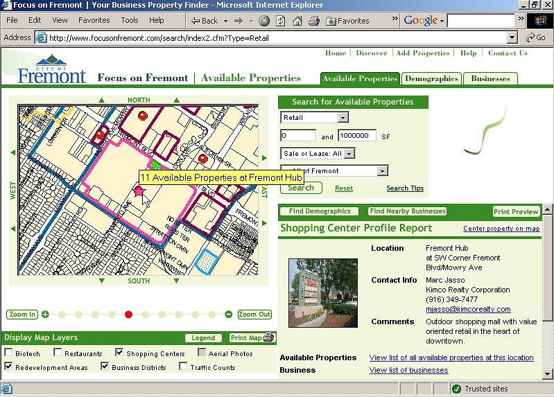 Click for larger view
The "Focus on Fremont" Web site launched in April 2003, built with the wealth of GIS information that city employees already had access to, via an Intranet site called GIS Online.Using MapGuide, the mapping solution from Autodesk, Fremont employees in several departments have long been able to search for data on zoning, assessing, police and fire reporting areas, and more.The "Focus on Fremont" Web site brings together all of these sources so that visitors can see as much data, or as little data, as they need. For instance, a site user can select a given available property, and is then presented with a map with "zooming" capability.(The user can also narrow down the available sites by selecting desired square footage, redevelopment areas, or specific sections of the city.) The user can the select the layers of data to be viewed on the map, such as nearby restaurants and shopping centers, aerial photos, business districts and traffic counts. By selecting a given radius around the available location (anywhere from a quarter of a mile to 10 miles), a user can receive demographic information - which is critical when deciding on a location for a retail business. "We don't just have a listing of properties - you can do a demographic search of the area, and also see what other businesses are there," Speck explains."This helps highlight the redevelopment areas - it would be hard to get a sense of those areas as cohesive districts without the mapping function." The beauty of the "Focus on Fremont" site and its multi-layered approach to data is that it can continue to absorb new sources of information as they become available. "A lot of data coming from multiple sources has translated into GIS terms," says Frost."The available property data was originally spearheaded by the redevelopment group going out and doing a site survey of what was available.So, we started out with a pretty small data set, and then Derek's group has done a great deal of outreach to the local brokers to get them to participate in getting information on what is available." Since its launch last year, more than 3900 unique users have visited the "Focus on Fremont" site."We do have a lot of property brokers out there using it," Speck says."One broker in particular that I talked to seemed astonished, and said, 'Wow, how long have you guys had this, and why don't other cities have this?' So we've gotten good feedback." "Before, I might have spent hours compiling this information for my clients," says local retail broker and frequent site visitor Fernando Cuebas."Because the information is tied to maps, it's more useful than information I track down over the phone.With traffic counts, I can see the way the traffic actually flows in an entire area." Speck also believes that new entrepreneurs are benefiting from the easy-to-use site."I think one of the best aspects of this site is that it's accessible to the small business owners or small property owners.For instance, we had one who wanted to start up a training center and was looking for 20,000 square feet.Being able to go in and see what spaces are available and what the zoning is, and what surrounding businesses are, was very helpful for him." The benefits accruing from the site aren't just going to external users.Frost says the city's zoning and economic development staff spend considerably less time on the phone and doing research relating to real-estate queries. "Our staff now can run their own demographic reports," she explains. "We were having to go out-of-house to have a report generated whenever someone was looking at a specific site in the city, so now it reduces that cost for each individual report.And of course, we can now pull up the reports in just a few minutes, and get the information to the brokers and to the property owners right away." |
Saying Farewell to an Amazing Journey
Communicating with Maps
Is There a GIS Career Ladder?
What does it mean to be geospatially smart? Series
Ways Real Estate and Property Developers Utilize Melissa GeoData for Data-Driven Decisions
Unlocking Value From Daily Satellite Imagery and Insights
Maximizing the Value of Your Address Data with Geo Addressing
How Indoor Mapping Enhances the Security of Smart Buildings
Look Ahead: AI, Location Intelligence and Efficiency
Collaboration Takes on Sea Level Rise & Dynamic Technology Environments
Brownies for Brownfields
Has Everything Been Mapped Already?
How Is Data Literacy Changing in an Artificial Intelligence Landscape
Portfolios for GIS Professionals: More Than Just Maps
How to Create a Distance Matrix in QGIS - A Step-by-Step Guide
7 Ideas for Bringing GIS into the K-12 Classroom
The Geography of Movement