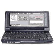
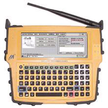
The iTalk™ rapid damage assessment application running on HP Jornada™ and SideArm™ handheld PCs.
We find that most emergency mangers we have spoken to agree that too much time is spent manually logging information into databases in the Emergency Operation Center.Affordable and effective wireless handheld technologies and applications allow the incident commander and field personnel to capture and communicate information to EOC's in near real-time.This technology shows great promise in helping to reduce double entry of data and freeing the emergency manager to focus on coordinating response and recovery activities and resources.
Technologies Tested
Rapid Collection and Real-time Communication of Disaster Information - using a catastrophic earthquake scenario and a Rapid Damage Assessment application, test use ofhandheld computing devices to collect and communicate building damage data for 'near real-time' display on an emergency management mapping system located in an operations center;
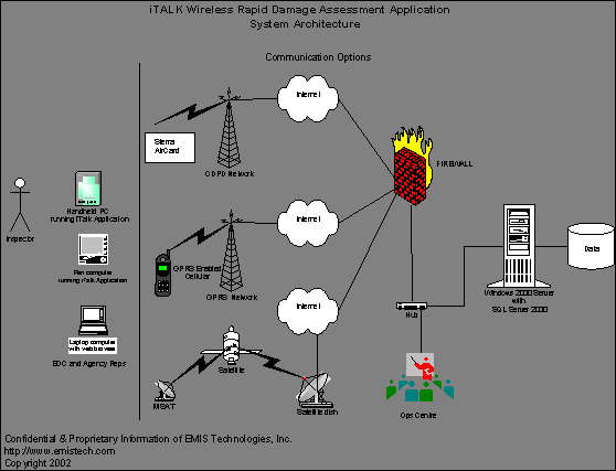
Wireless Communications - multi-mode wireless data transmission options to keep data flowing between field and EOC personnel, including use of affordable and broadly-used wireless networks such as CDPD (cellular packet), GSM/GPRS (radio packet) and MSAT (satellite);
Spatial Decision Support Applications - integrate data from multiple GIS (electronic) mapping systems and overlay predicted and actual (field) data in near real-time.
1. iTALK™ - Rapid Damage Assessment (RDA) Application.This handheld computer application developed by EMIS Technologies Inc.was used to collect and communicate geo-referenced building damage data based on ATC-20.The data was synchronized with a database repository in the EOC and quickly displayed on the emergency management mapping applications.The application is tailored for building damage assessments but is currently being extended to allow assessment of any critical infrastructure and incorporate daily-use application for emergency responders.
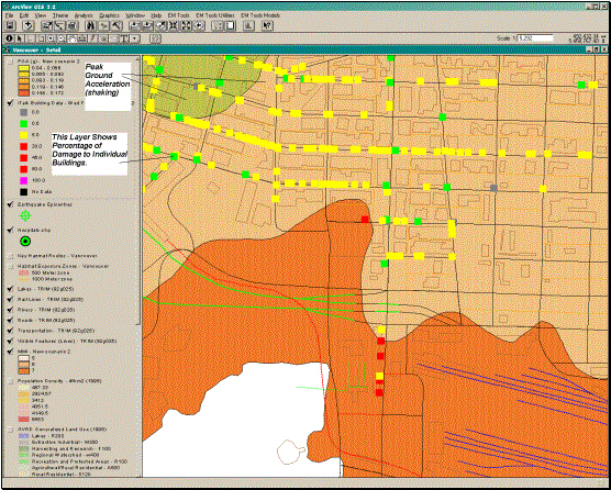
2. ArcView™ 3.2 with theEM-Tools™ Earthquake Hazard Model.A hazard model developed by Lookfar Solutions Inc.generates predicted damage maps based on Modified Mercalli Index (MMI) and Peak Ground Acceleration (PGA) to help responders prioritize assessment areas and response/recovery activities.As actual building damage information begins to come in from the field, color-coded icons representing building placards are overlaid on the predicted damage data to produce an increasingly accurate account of damage.Three types of output can be displayed on maps: building status (placard posting), extent of dollar loss, and indicators of possible number of people at risk.
These damage map 'layers' were also
being displayed 'real-time' and in their native formats over the City of
Vancouver's existing web-based GIS system (using AutoDesk MapGuide™)
.

3. Web-based Reporting.Crystal Reports™, a web-based reporting tool, was used to publish damage summary reports in formats useful to the desktop (EOC) users and the handheld (field) users.
Other technologies tested in the demonstration were:
- Mitsubishi ST111 Mobile Satellite Terminal™.
- Garmin GPS V™ (http://www.garmin.com/products/gps5/).
- HP Jornada™ 720 Pocket PC running Windows CE and SQL CE.
- Melard SideArm™ Ruggedized Handheld Computer.
- Microsoft SQL 2000™ Server.
Results and 'Lessons Learned'
Rapid Damage Assessment using Handheld Devices
- screen display washes out in bright sunshine;
screen displays on the handheld devices were wide enough to accommodate the ATC-20 form layout but other Pocket PC and Palm devices lacked the screen real estate to be considered a viable option for this particular application;
'ruggedized' and 'weather-proof' devices, like the Melard SideArm device tested, will be required for most field applications;
- many handheld devices lack sufficient integrated components and ports to enable simultaneous operation of multiple input/output devices, such as GPS and multiple communications cards (expansion devices help but add to the 'clutter');
- the HP Jornada's integrated keyboard was useful for the small amount of data entry required in the ATC-20 forms, whereas many other handheld devices rely on a 'pop-up keyboard' that hides 1/3 of the display screen.External keyboards are not likely to be used by an inspector while assessing a building.
Wireless Communications
Tests showed a great deal of network latency when synchronizing data from the handheld device and the enterprise server.A new building assessment record took just under 3 minutes to synchronize with the server database; however, displaying the Damage Report web page was much quicker (20-30 seconds). EMIS Technologies has since found a solution to minimize this latency that appears related in part to the way GPRS handles data packets during the database synchronization process.
MSAT is one of several satellite communication options available and was tested as a potential third-tier network solution (in the event that CDPD and GPRS are not available).A serial cable connected the handheld device to a mobile satellite terminal and a dial-up (PPP) TCP/IP connection established through a local application service provider (ASP).
MSAT testing proved challenging.We were surprised to discover that several ASP's did not support a 4800 BPS connection; therefore, we had to set-up a dedicated dial-up server at EMIS' office.Even though we were doing a straightforward dial-up connection, we discovered that Windows CE registry settings had to be changed to get the connection working (an undocumented problem).Once connected, we were able to synchronize our damage assessment data with the EOC server within 5 minutes.It is not a surprise that moving data satellite is a slow option right now but during a catastrophic event, there may be no better options and improvements are coming.
Real-time, Multi-vendor GIS Decision Support Tools
The Future
Mike Morrow is president of EMIS Technologies Inc., an emergency management technology consultant, based in Vancouver, B.C.For the past fourteen years, Mike has helped in the design, development, implementation, training and support of emergency management information systems for EOC's around the world.His most recent achievements were the implementation of a comprehensive emergency management information system for the City of Vancouver and the B.C.Provincial Emergency Program (using EM/2000™) and a special events logging system for the G8 Summit Meeting in Banff, Alberta.To contact Mike, call (604) 688-4499 or visit www.emistech.com