Background
It is that time of year again; when the Atlantic waters heat up, skies darken, and bandwidth on hurricane web sites dwindles away to nothing. The Hurricane season started June 1, and runs through November 30. While many web sites are available to view ready-made hurricane maps, those for whom hurricane activity is professionally important will do better to make their own.There are of course many places to go to find ready-made tracking maps. A quick query of your favorite search engine for "hurricane track map" will return anywhere from five thousand to 2 million pages. Here are some direct links:
However, the typical site shows only the storm track, intensity and the 72-hour forecast. Here are two examples of typical hurricane maps depicting last year's Hurricane Georges.
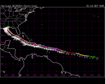
UNISYS Hurricane Tracking Map
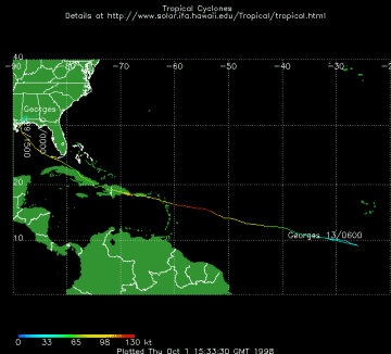
University of Hawaii Tracking Map
Why Make Your Own
With all those resources, why do I suggest you go through the trouble of re-inventing your own hurricane map? The answer lies in the benefits of responsiveness, and of having the map tailored to your specific needs.
It is important to realize that what is shown on most weather sites is just a small portion of the available meteorological data. Much more data are available from the actual hurricane forecasting models' output. Public web sites show only the "official" National Hurricane Center track. But you may want to plot all the individual forecasts to evaluate the variance between them. In addition, there are aircraft reconnaissance, landfall probabilities, and wind field pattern reports; any one or several of which may be important to you or your organization.
Many professions: federal, state and local planners; relief organizations; insurance companies; others involved in risk assessment, exposure, and response; and others have a strong professional interest in monitoring and modeling hurricane behavior.
You may desire a projection that depicts direction better than scale. And you likely have a specific focus area that you want maintained within the map view at all times, one that will include your critical facilities.
There are the added benefits of time and access. The raw data is often available at least 15 minutes before the "official" release time; and you do not have to go through some slow, high traffic site to see the maps.
Here is a simple example of a custom hurricane map showing position with forecasted track, 36-hour landfall probabilities and wind fields.

Track / Landfall / Windfield (click to enlarge)
Another example below shows the 'official' forecasted track, as well as the model output from four other forecasting engines.
Track / Other Models / Recon (click to enlarge)
How To Do It
There are a number of ways to get the hurricane data on-line via telnet, WWW or e-mail. Section "I" of the Hurricane FAQ (at the Atlantic Oceanographic & Meteorological Laboratory at the National Oceanic & Atmospheric Administration) lists these resources and explains where they are available. Some of the most useful data comes from the following advisories (click the link to see a sample report):- Forecast: Position, speed, bearing and wind fields.
- Discussion: Narrative, forecast positions and maximum wind speeds.
- Strike Probabilities: List of cities, islands and coordinates with chance of eye passing within 65 nautical miles in the next 36 hours.
- Guidance: Output from various models (format and models vary by source).
- Recon: Snapshot of data from Hurricane Hunter aircraft reconnaissance.
These reports come in standardized formats. It is a one-time and relatively simple task to develop parsing programs that will turn these data into point files to feed the mapping software you use. Most of the data are simple long/lat pairs, which can be displayed as points or connected as polylines. The strike data is often portrayed by a series of wedges from the eye to the shore (however my preference is a buffered band around the coastline). The wind fields take a bit more time and effort, as you are only given four control points from which to create contours. With a little interpolation, trigonometry and object combining, acceptable results can be achieved.
Here is a snippet of code that demonstrates the parsing principles involved. Although this code is written in MapBasic (the customization language I use with MapInfo Professional) the technique is easily adapted to ArcView's Avenue or other tools.
Summary
Few sites include all the available data, and it is doubtful whether any one of them contains all of the information you will want. By making your own hurricane maps, you'll have live GIS data with which to analyze your sites, predict damages and formulate responses.Related Links
- Descriptions and methods of the major forecasting models from the National Hurricane Center.
- Archive of tropical cyclone data at Florida State University.
- Hurricane FAQ from the Atlantic Oceanographic and Meteorological Laboratory.
- How to decode hurricane RECON reports from Florida State University.