Wow Technology at Autodesk University 2006
Getting from CAD to GIS: Perspectives from the Autodesk Geospatial User Community
Keynote Presentations
At the opening plenary session of Autodesk University this year, CEO Carl Bass (pictured below) played to his company's strength by focusing on 3D visualization and allowing partners to demonstrate project successes. The "wow" factor was a successive display of 3D models that was best summarized by Bass when he said that "the power of building digital prototypes is to enable you to better understand, analyze and communicate designs (and) . . . experience it before it is real." Of course, 3D visualization is not new and Autodesk, along with other CAD and GIS companies, has always played to this "wow" factor of fly-throughs and "real-world" models of design drawings.
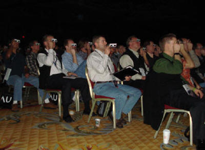
What I saw at Autodesk University was the continuing evolution of visualization tools which, when tied to a database, allow users to isolate individual features, retrieve metadata more easily, and integrate other disparate data (imagery, rendered drawings like building facades, and terrain). In addition, users like Parsons Brinckerhoff highlighted one of Autodesk's great strengths, product interoperability, with a demonstration of the integration of Civil 3D, Revit, and 3DMax. Parson's virtual technology officer, Doug Eberhardt, further demonstrated his company's visualization prowess by giving 3D glasses to the entire audience and then continuing his presentation so they could see city infrastructure models in 3D.
 |
 |
However, the most impressive demonstration of the opening session, from a geospatial perspective, was a 3D model of the city of London, England developed from aerial images by GMJ. GMJ works with architectural firms to help them create 3D models. The London city model that GMJ created covered 36 square kilometers. It was an impressively complete model that showed building footprints and a correct elevation model but did not include a rendered facade. Using this geospatially accurate digital model, GMJ intends to license the data for any number of applications, from viewshed analysis for security purposes to urban planning and zoning. The company intends to create models of other cities and license the data to both governments and commercial firms.
Autodesk's Mike Legg, a retired Lieutenant Colonel formerly with Special Operations Command, delivered another geospatial demo on situational awareness on the battlefield. His demonstration used IMOUT, a software solution to visualize a city from multiple viewpoints. Using an Autodesk Revit model of a building, field commanders and troops can see what both the interior and exterior of the building look like before they enter it. Outside views of the surrounding cityscape are useful for route planning. Security teams can determine areas of security concerns (ambush?). In addition, sub-street utility infrastructure information can also allow troops to see what assets may be in play.
Bass also introduced a location-based services demonstration given by Dave Trahan of Patriot Mechanical, an HVAC company from northern California that has been using Sprint Mobile Locator to become more competitive and help manage its mobile workforce. The workflow Trahan demonstrated showed how the company follows the progress of workers throughout the day and provides communication through text messages to workers' cell phones. Turn-by-turn directions help technicians find their next destination and help to maximize resources by showing which technician is closest to the next sales or service call.
Some Non-geospatial Demos
Tomas Herrman, Autodesk Alias product manager, demonstrated how this product is accelerating automotive design. Alias takes the user from sketch to design by offering a symmetrical canvas: while the artist draws in one portion of the "canvas" window, the product creates a symmetrical drawing on the opposite side of the canvas. From here, the user can create photorealistic models.
Steve Glenn, founder of Living Homes, demonstrated how to leverage Autodesk Revit to manage all phases of the construction of the modular components of a residential home. Living Homes develops modular homes with modern designs, so it is necessary to manage the prefabrication production process while maintaining a philosophy of environmental sensitivity. His modular homes can be assembled on site in eight hours.
Autodesk's Geospatial Product Updates
Autodesk Map 3D 2007
Autodesk focused on small incremental improvements in the 2007 version of Autodesk Map 3D. Those who can benefit most are users who want to move from non-georeferenced data stored in Autodesk LT to Map3D, thus providing real world positioning of CAD drawings. There is support for georeferenced raster images, as well as the ability to fix overshoots and undershoots; spatial querying is a big advantage. Also new is support for Feature Data Objects (FDO), which allows direct access to disparate data types (e.g. SHP, MID, E00) instead of having to import them. The Display Manager in Map 3D 2007 gives you the capability to create thematic maps based on database links, and natively access different data types (raster images included). Ten FDOs are currently available so there is a lot less need to import disparate data types with this version of Map3D.
AutoCAD is the kernel for Map 3D; likewise users of Civil 3D already have Map 3D; Civil 3D is a wrapper around Map3D and Map3D is a wrapper around AutoCAD.
MapGuide Open Source (MGOS)
MGOS 1.0.2 is available now. MGOS 1.1.0 is planned for availability in December 2006. Features in the MGOS 1.1.0 release include:
- Dynamic KML/KMZ support
- Update to FDO 3.2
- Dynamic Long Transaction support
- Integrate provider into install
- Tighter integration of API into .NET Framework.
- Performance enhancements
- Programmatic load balancing
- Support for unmanaged data sources
- Feature Join
- MRU Tile Cache Management.
Several sessions at the conference focused on helping users migrate from MapGuide 6.5 to the new MapGuide technology. MapGuide Enterprise is designed as server side technology allowing access to disparate data types using FDO as well as the ability to execute spatial queries. As a server-based technology it is also browser independent and no longer requires a plug-in. An API is available to help customize development in either .NET or Linux and an API to develop FDOs is also available from the OSGeo website. Autodesk has provided extensive online resources and white papers to guide users in the process of migrating to MapGuide Open Source or MapGuide Enterprise.
[Disclosure: Autodesk paid for travel and lodging for this event.]
From Our Homepage
Saying Farewell to an Amazing Journey
Communicating with Maps
Is There a GIS Career Ladder?
What does it mean to be geospatially smart? Series
Ways Real Estate and Property Developers Utilize Melissa GeoData for Data-Driven Decisions
Unlocking Value From Daily Satellite Imagery and Insights
Maximizing the Value of Your Address Data with Geo Addressing
How Indoor Mapping Enhances the Security of Smart Buildings
Look Ahead: AI, Location Intelligence and Efficiency
Collaboration Takes on Sea Level Rise & Dynamic Technology Environments
Brownies for Brownfields
Has Everything Been Mapped Already?
How Is Data Literacy Changing in an Artificial Intelligence Landscape
Portfolios for GIS Professionals: More Than Just Maps
How to Create a Distance Matrix in QGIS - A Step-by-Step Guide
7 Ideas for Bringing GIS into the K-12 Classroom
The Geography of Movement