I believe the best part of technology is playing with
it. Anything that gets between receiving new software and using it
(such as a tough installation, getting an activation code or installing
yet another update to the Java Virtual Machine) is sheer torture. And
that goes for anything related to reading licenses or Terms of Service,
which often means clicking through pages of tightly spaced legalese.
I'm not alone. A recent Directions Magazine survey found that about half of the nearly 100 respondents said they don't read license documents. I am seeing rays of hope, however. Recent changes, especially to mapping website and application programming interface (API) Terms of Service are making news. When Google recently broke an agreement by using an undocumented Apple iPhone feature, the press was quick to out the company.
So, perhaps this is the moment to muster some courage, set aside some time, wrap a cold towel around your head and explore license documents. This article serves as an introduction to some key ideas to consider as you wade through the various licenses (discussed in passing) and Terms of Service (the prime focus herein) that you may see in your studies or work involving geospatial technology.
Licenses, EULAs and Terms of Service Explained
A driver's license is a document given by an authority that grants you the right to legally drive a car. Driving without such a license in many areas of the world means you run the risk of legal trouble. In the case of software licenses, the grant - what the license authorizes - is different. Instead of allowing you to do something (drive, fish, hunt, teach), it allows you to use and/or distribute a software program. The license typically details each party's liability related to that use or distribution, among other things.
As software moved from the desktop to the Web, End User License Agreements (EULAs) for standalone software products gave way to Terms of Service, Terms of Use, Acceptable Use and Developer Agreement documents.
These documents were initially designed to protect software developers from having users inappropriately distribute their software and to limit liability, but now they include far more. For example, some geospatial software EULAs include language prohibiting users from publishing benchmark results involving the applications. Some Web services have an age restriction: To use Google Search you must be "of legal age to form a binding contract with Google," which in all U.S. states is 18 years old.
Most readers are likely to be familiar with "clickthrough" or "clickwrap" licenses which pop up during software installation or registration. The user must agree to the license/Terms of Service by clicking "yes, I agree" before going forward. In the old days, when software was delivered on media, the license was assumed to be accepted when the user opened the package, such as by ripping the shrink wrap or opening an envelope. Shrinkwrap licenses caused a bit of consternation since in many cases the full text of the license was only available after opening the package.
Terms of Service (ToS - I'll be using that acronym to refer to any of the various terms related to Web service agreements) may be implemented more subtly. When you visit a website, it's rare to have to "clickthrough" to accept its conditions. In fact, many ToS agreements state something on the order of, "By using this site you agree to its terms." For sites that offer an account, you typically are asked to accept the ToS when you set it up. Consider PolicyMap, "a revolutionary, easy, new way to explore geographic data through maps, tables and reports." Here's an example of language from the PolicyMap Terms of Use:
The ToS vary depending on what you do at, or with, a mapping website. We'll divide those activities into three categories:
With that in mind, let's take a look at some of the ToS agreements that relate to these activities.
Making Maps
Web users have been using MapQuest and similar sites to locate addresses and get directions for years. While these sites offer some very generous terms, others may be surprising.
The MultiMap Legal and Copyright Information details some practices that are forbidden without explicit permission.
For example, while you may print out copies of maps for your own use, "You may not print more than 10 copies of any maps or other materials from the Site."
Also, "You are not allowed to capture any map images, map data or lat/lon information from the Site," though you are allowed to maintain a cache of the maps as part of your browsing experience.
The Microsoft Live Search Maps ToS (which covers other services as well) includes this notice requiring that visitors:
" • obey the law;
• obey any codes of conduct or other notices we provide;
• obey the Microsoft Anti-spam Policy, which is available at http://privacy.msn.com/anti-spam
• keep your service account password secret; and
• promptly notify us if you learn of a security breach related to the service."
Thus, visitors agree to the terms stated along with those detailed on the Anti-spam Policy. It's very common for one ToS to reference one or more other documents; the MultiMap ToS also references a Privacy Policy and data copyright information.
Multimap's Privacy Policy
Full Copyright Terms
The Yahoo Maps ToU (Terms of Use) provides explicit details, including the format, allowed for data sharing with a third party:
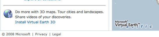
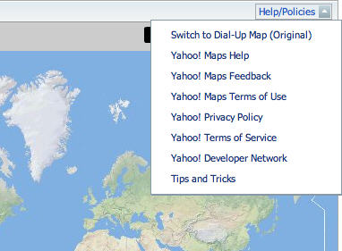
Note that to accept such agreements, the end user must find and read the documents. Web mapping sites' ToS pages are becoming more prominent and easy to find. MultiMap includes them in a footer. Yahoo Maps puts all the relevant links to documents in a pulldown menu above the map. Microsoft offers a "Legal" link below the map.
Building Mashups
Let's move on to a "deeper" use of mapping services: building mashups using an API. In that case an additional document or one substantially different from an "end user" ToS may apply.
Google uses a single document for both the Google Maps and Google Earth APIs. At the very top is the date of the document's last update. As of this writing, that update occurred on November 26, 2008. That's a good reminder that ToS agreements change. Google (and many others) include details about the licensee's (that is, the developer's) responsibility regarding ToS changes in the document.
Reading down the ToS, Google states that Google does not commit to the Maps/Earth APIs always being available in the same form:
For comparison, Microsoft includes this statement regarding licensee content. It covers other Microsoft services beyond just Live Search Maps.
Finally, let's take a look at ToS agreements as they relate to licensees creating or adding data to an existing database. In this section, we'll explore services specifically designed for users to submit geodata to help build out core geographic basemaps.
One such service, OpenStreetMap (OSM), dates back to 2006 and aims to create a freely useable worldwide map. The map data are licensed under Creative Commons, a license that allows creators to both hold copyright and share content with specific limitations (which range from none to some, the most common being a requirement of attribution). When you upload data to OSM, per the Legal FAQ:
OSM may be the best-known, but it's not the only "crowdsourcing" effort underway to "fill in" a world map. Google launched Map Maker in June 2008 in just under 20 countries to try to fill in gaps in its coverage. Today Map Maker is open to contributions of data from 164 countries. Its ToS states:
A Real Life Example: The Ordnance Survey, OpenSpace, Google Maps and Terms of Service
In the introduction I noted that I'm hopeful about users and developers paying more attention to ToS agreements, in part because these documents are making news. One example in recent months involved the Ordnance Survey, its service called OpenSpace and its data. Many of the ideas, cautions and concerns in the preceding sections pop up in this story, which spanned approximately a 12-month period: Dec. 2007-Dec. 2008.
It's well-known that Britain's national mapping agency, the Ordnance Survey (OS), does not give its data away for free. Instead it licenses the data to public and private entities for use in print, online and in mobile devices. That meant that until recently, only those with sufficient funds could gain access to the data for Web mapping. After much discussion, and some encouragement from government reviews of how public information is created and shared over the Internet, the OS announced OpenSpace, a mapping API made available for non-commercial use. It went into alpha at the end of 2007 and was open to all in January 2008.
Over the summer of 2008, the UK government held a contest called "Show Us A Better Way," which sought applications demonstrating how government information could be made more useful and accessible to the public. Many of the entries took advantage of OpenSpace. The Guardian newspaper's Free Our Data blog details them. The OS offered its support to grow the apps to their potential.
Once the winners were announced in October 2008, the OS sent a document (PDF) to local governments to help clarify their use of data derived from OS data. That document, suggests the Guardian, may put the contest winners' solutions in jeopardy. The crux of the matter is found in the OpenSpace Developer Agreement and it pertains to what it calls "Derived Data." The phrase refers to any data made based on OS data. If you geocode points using OS data, you've created Derived Data. If you draw a boundary on top of OS data, you've created Derived Data. Now, the thing about Derived Data, again, per the ToS, is that the OS owns the data. It says exactly that in the Developer Agreement: "In the event that You or any End user creates Derived Data, such Derived Data shall be owned by Us..."
That ownership caused challenges for local governments because they wanted to take their Derived Data and display them using another client, Google Maps. But in doing so, via the Google Maps ToS (which we examined above), those local governments were giving Google rights to the Derived Data. The problem? The local governments could not give Google such a license since they didn't own the data; the Ordnance Survey did!
By the end of November 2008, the OS updated its Developer Agreement to allow a bit more flexibility. The crux of the announcement was that those who license OS data can now use the same OpenSpace API (but in an open source version) to build commercial applications. The only changes to the OpenSpace Developer Agreement seem to be related to minor changes in the definitions and licensing of "Your Data," "End-user's Data" and "Derived Data." In particular, the license of Your, End-user's and Derived Data back to the Ordnance Survey now all end when those data are removed from the OpenSpace-based app or the Developer Agreement is terminated. (The Ordnance Survey has not responded to multiple queries on these apparent changes as we go to press.)
The announcement solves only some of the issues related to creating data with OS maps and putting those data on maps on the Internet. It sounds as though this story will continue, perhaps with further changes to the OpenSpace and other OS ToS agreements in 2009 and beyond.
How to Get Around These ToS Agreements (But Run into Others)
If all these ToS agreements seem too much to handle, is it worth considering hosting your own Web maps? That would allevaite the need to read all of the different ToS documents and agree to them. However, it doesn't mean you won't have to read or agree to anything! You'll still need to read and agree to your Internet Service Provider's ToS and the EULA of the software you select to run. You'll also need to follow any usage guidelines related to the data you publish. And, you will likely need to compose your own ToS document to let visitors know what they are permitted to do with the data and services you offer, and how you may use data they share or submit.
In particular, as you explore ToS agreements, pay close attention to:
Further Reading
Click to Agree - from NPR's "On the Media"; explores Terms of Service and why they exist, who reads them and more.
Transcript
The New Hacker (transcript) - On Terms of Service and how and why the MySpace suicide case found Lori Drew guilty of violating the ToS.
For more on others areas of concern regarding EULAs, read about them at What is it?
I'm not alone. A recent Directions Magazine survey found that about half of the nearly 100 respondents said they don't read license documents. I am seeing rays of hope, however. Recent changes, especially to mapping website and application programming interface (API) Terms of Service are making news. When Google recently broke an agreement by using an undocumented Apple iPhone feature, the press was quick to out the company.
So, perhaps this is the moment to muster some courage, set aside some time, wrap a cold towel around your head and explore license documents. This article serves as an introduction to some key ideas to consider as you wade through the various licenses (discussed in passing) and Terms of Service (the prime focus herein) that you may see in your studies or work involving geospatial technology.
Licenses, EULAs and Terms of Service Explained
A driver's license is a document given by an authority that grants you the right to legally drive a car. Driving without such a license in many areas of the world means you run the risk of legal trouble. In the case of software licenses, the grant - what the license authorizes - is different. Instead of allowing you to do something (drive, fish, hunt, teach), it allows you to use and/or distribute a software program. The license typically details each party's liability related to that use or distribution, among other things.
As software moved from the desktop to the Web, End User License Agreements (EULAs) for standalone software products gave way to Terms of Service, Terms of Use, Acceptable Use and Developer Agreement documents.
These documents were initially designed to protect software developers from having users inappropriately distribute their software and to limit liability, but now they include far more. For example, some geospatial software EULAs include language prohibiting users from publishing benchmark results involving the applications. Some Web services have an age restriction: To use Google Search you must be "of legal age to form a binding contract with Google," which in all U.S. states is 18 years old.
Most readers are likely to be familiar with "clickthrough" or "clickwrap" licenses which pop up during software installation or registration. The user must agree to the license/Terms of Service by clicking "yes, I agree" before going forward. In the old days, when software was delivered on media, the license was assumed to be accepted when the user opened the package, such as by ripping the shrink wrap or opening an envelope. Shrinkwrap licenses caused a bit of consternation since in many cases the full text of the license was only available after opening the package.
Terms of Service (ToS - I'll be using that acronym to refer to any of the various terms related to Web service agreements) may be implemented more subtly. When you visit a website, it's rare to have to "clickthrough" to accept its conditions. In fact, many ToS agreements state something on the order of, "By using this site you agree to its terms." For sites that offer an account, you typically are asked to accept the ToS when you set it up. Consider PolicyMap, "a revolutionary, easy, new way to explore geographic data through maps, tables and reports." Here's an example of language from the PolicyMap Terms of Use:
BY REGISTERING OR BECOMING A SUBSCRIBER OR BY ACCESSING, BROWSING, SAVING OR PRINTING ANY INFORMATION OR OTHERWISE USING THIS SITE, YOU ACKNOWLEDGE THAT YOU HAVE READ, UNDERSTOOD, AND AGREE TO BE BOUND BY THESE TERMS OF USE. IF YOU DO NOT AGREE TO ALL OF THESE TERMS OF USE, YOU ARE NOT PERMITTED TO ACCESS, BROWSE OR OTHERWISE USE THIS SITE OR THE INFORMATION CONTAINED THEREIN.Web Mapping Services: Different Terms of Service for Different Types
The ToS vary depending on what you do at, or with, a mapping website. We'll divide those activities into three categories:
- making maps, getting directions (doing "end user" types of things)
- building a mashup (creating a new map or app from the service and some external data)
- creating data (drawing points of interest or adding data to an existing database)
With that in mind, let's take a look at some of the ToS agreements that relate to these activities.
Making Maps
Web users have been using MapQuest and similar sites to locate addresses and get directions for years. While these sites offer some very generous terms, others may be surprising.
The MultiMap Legal and Copyright Information details some practices that are forbidden without explicit permission.
For example, while you may print out copies of maps for your own use, "You may not print more than 10 copies of any maps or other materials from the Site."
Also, "You are not allowed to capture any map images, map data or lat/lon information from the Site," though you are allowed to maintain a cache of the maps as part of your browsing experience.
The Microsoft Live Search Maps ToS (which covers other services as well) includes this notice requiring that visitors:
" • obey the law;
• obey any codes of conduct or other notices we provide;
• obey the Microsoft Anti-spam Policy, which is available at http://privacy.msn.com/anti-spam
• keep your service account password secret; and
• promptly notify us if you learn of a security breach related to the service."
Thus, visitors agree to the terms stated along with those detailed on the Anti-spam Policy. It's very common for one ToS to reference one or more other documents; the MultiMap ToS also references a Privacy Policy and data copyright information.
Multimap's Privacy Policy
Full Copyright Terms
The Yahoo Maps ToU (Terms of Use) provides explicit details, including the format, allowed for data sharing with a third party:
Accordingly, but subject to the restrictions set forth in the following paragraphs, you may copy this Data only as necessary for your personal use to ...The Yahoo Maps ToU also references a second document, the Notice of Use from NAVTEQ.
v) transfer a copy, in html form only, to a third party provided that you do not remove any copyright notices that appear and do not modify the Data in any way.
Note that to accept such agreements, the end user must find and read the documents. Web mapping sites' ToS pages are becoming more prominent and easy to find. MultiMap includes them in a footer. Yahoo Maps puts all the relevant links to documents in a pulldown menu above the map. Microsoft offers a "Legal" link below the map.
 |
 |
Building Mashups
Let's move on to a "deeper" use of mapping services: building mashups using an API. In that case an additional document or one substantially different from an "end user" ToS may apply.
Google uses a single document for both the Google Maps and Google Earth APIs. At the very top is the date of the document's last update. As of this writing, that update occurred on November 26, 2008. That's a good reminder that ToS agreements change. Google (and many others) include details about the licensee's (that is, the developer's) responsibility regarding ToS changes in the document.
"1. 1.5 Changes to the Terms. Google reserves the right to make changes to the Terms from time to time. When these changes are made, Google will make a new copy of the Terms available at http://code.google.com/apis/maps/terms.html. You understand and agree that if you use the Service after the date on which the Terms have changed, Google will treat your use as acceptance of the updated Terms. If a modification is unacceptable to you, you may terminate the agreement by ceasing use of the Maps APIs."Be aware that these terms do not say that Google is obligated to tell the licensee the terms have changed. The licensee is responsible for keeping up-to-date. Indeed, this set of terms changed several times within the month of November 2008 alone! Further, this ToS references and requires acceptance of two other documents, which may themselves change: Google's Legal Notices and Privacy Policy.
Reading down the ToS, Google states that Google does not commit to the Maps/Earth APIs always being available in the same form:
"You acknowledge and agree that the form and nature of the Service that Google provides may change from time to time without prior notice to you. "One of the recent topics of discussion (which relates to the many updates of the Google Maps/Google ToS in November 2008) addresses Google's use of the licensee's data. Currently, the relevant paragraph reads:
"You acknowledge and agree that Google may impose or adjust the limit on the number of transactions you may send or receive through the Service; such fixed upper limits may be set by Google at any time, at Google's discretion."
"Google reserves the right to release subsequent versions of the Maps APIs and to require you to obtain and use the most recent version."
"Google reserves the right to include advertising in the maps images provided to you."
11.1 Content License. Google claims no ownership over Your Content, and You retain copyright and any other rights you already hold in Your Content. By submitting, posting or displaying Your Content in the Service, you give Google a perpetual, irrevocable, worldwide, royalty-free, and non-exclusive license to reproduce, adapt, modify, translate, publicly perform, publicly display and distribute Your Content through the Service and as search results through Google Services. This license is solely for the purpose of enabling Google to operate the Service, to promote the Service (including through public presentations), and to index and serve such content as search results through Google Services. If you are unable or unwilling to provide such a license to Your Content, please see the FAQ for information on configuring your Maps API Implementation to opt out.Product Manager Mickey Kataria and Geospatial Technologist Ed Parsons of Google document the succession of changes to this paragraph in a series of blog posts: Update to the Google Maps API Terms of Service (Kataria, Nov 26), Updating the Terms of Service (Kataria, Nov 12), Everybody reads the Terms of Service... (Parsons, Nov 27), Who reads the Terms of Service anyway... (Parsons, Nov 13).
For comparison, Microsoft includes this statement regarding licensee content. It covers other Microsoft services beyond just Live Search Maps.
You may be able to submit materials for use in connection with the service. The service includes publicly accessible areas ("public areas of the service") and areas to which you can control access by others ("shared and private areas of the service"). You understand that Microsoft does not control or endorse the content that you and others post or provide on the service. Except for material that we license to you, we do not claim ownership of the materials you post or provide on the service. However, with respect to content you post or provide you grant to those members of the public to whom you have granted access (for content posted on shared and private areas of the service) or to the public (for content posted on public areas of the service) free, unlimited, worldwide, nonexclusive and perpetual permission to:Further information is provided in the Microsoft Virtual Earth Platform API Terms of Use (recall that Live Search Maps is the "end user" application; Virtual Earth is the development platform with the API):
• use, modify, copy, distribute and display the content in connection with the service and other Microsoft products and services;
• publish your name in connection with the content; and
• grant these rights to others.
5. Your Content. Except for material that we may license to you, we do not claim ownership of the content you post or otherwise provide to us related to the service (called a "submission"). However, by posting or otherwise providing your submission, you are granting to Microsoft free permission to use, copy, distribute, display, publish, transcode and otherwise modify your submission, each in connection with the service, and sublicense these rights to others in order to provide the service.Creating Data
We will not pay you for your submission. We may refuse to publish, and may remove your submission from the service at any time. For every submission you make, you must have all rights necessary for you to grant the permissions in this section.
Finally, let's take a look at ToS agreements as they relate to licensees creating or adding data to an existing database. In this section, we'll explore services specifically designed for users to submit geodata to help build out core geographic basemaps.
One such service, OpenStreetMap (OSM), dates back to 2006 and aims to create a freely useable worldwide map. The map data are licensed under Creative Commons, a license that allows creators to both hold copyright and share content with specific limitations (which range from none to some, the most common being a requirement of attribution). When you upload data to OSM, per the Legal FAQ:
"...you are the copyright holder of your data, but you agree to license it under the terms of this licence.[sic] This means only you can relicense the data. The copyright of the whole data set is scattered among all contributors.Many contributors to community efforts such as OSM and Wikipedia feel good about contributing content to databases that will ultimately be free to use and distribute.
Some contributors release their contributions to the public domain."
OSM may be the best-known, but it's not the only "crowdsourcing" effort underway to "fill in" a world map. Google launched Map Maker in June 2008 in just under 20 countries to try to fill in gaps in its coverage. Today Map Maker is open to contributions of data from 164 countries. Its ToS states:
By submitting User Submissions to the Service, you give Google a perpetual, irrevocable, worldwide, royalty-free, and non-exclusive license to reproduce, adapt, modify, translate, publish, publicly perform, publicly display, distribute, and create derivative works of the User Submission.Note that this license gives Google even more ways to use the data than in the ToS for Google Maps/Google Earth API.
A Real Life Example: The Ordnance Survey, OpenSpace, Google Maps and Terms of Service
In the introduction I noted that I'm hopeful about users and developers paying more attention to ToS agreements, in part because these documents are making news. One example in recent months involved the Ordnance Survey, its service called OpenSpace and its data. Many of the ideas, cautions and concerns in the preceding sections pop up in this story, which spanned approximately a 12-month period: Dec. 2007-Dec. 2008.
It's well-known that Britain's national mapping agency, the Ordnance Survey (OS), does not give its data away for free. Instead it licenses the data to public and private entities for use in print, online and in mobile devices. That meant that until recently, only those with sufficient funds could gain access to the data for Web mapping. After much discussion, and some encouragement from government reviews of how public information is created and shared over the Internet, the OS announced OpenSpace, a mapping API made available for non-commercial use. It went into alpha at the end of 2007 and was open to all in January 2008.
Over the summer of 2008, the UK government held a contest called "Show Us A Better Way," which sought applications demonstrating how government information could be made more useful and accessible to the public. Many of the entries took advantage of OpenSpace. The Guardian newspaper's Free Our Data blog details them. The OS offered its support to grow the apps to their potential.
Once the winners were announced in October 2008, the OS sent a document (PDF) to local governments to help clarify their use of data derived from OS data. That document, suggests the Guardian, may put the contest winners' solutions in jeopardy. The crux of the matter is found in the OpenSpace Developer Agreement and it pertains to what it calls "Derived Data." The phrase refers to any data made based on OS data. If you geocode points using OS data, you've created Derived Data. If you draw a boundary on top of OS data, you've created Derived Data. Now, the thing about Derived Data, again, per the ToS, is that the OS owns the data. It says exactly that in the Developer Agreement: "In the event that You or any End user creates Derived Data, such Derived Data shall be owned by Us..."
That ownership caused challenges for local governments because they wanted to take their Derived Data and display them using another client, Google Maps. But in doing so, via the Google Maps ToS (which we examined above), those local governments were giving Google rights to the Derived Data. The problem? The local governments could not give Google such a license since they didn't own the data; the Ordnance Survey did!
By the end of November 2008, the OS updated its Developer Agreement to allow a bit more flexibility. The crux of the announcement was that those who license OS data can now use the same OpenSpace API (but in an open source version) to build commercial applications. The only changes to the OpenSpace Developer Agreement seem to be related to minor changes in the definitions and licensing of "Your Data," "End-user's Data" and "Derived Data." In particular, the license of Your, End-user's and Derived Data back to the Ordnance Survey now all end when those data are removed from the OpenSpace-based app or the Developer Agreement is terminated. (The Ordnance Survey has not responded to multiple queries on these apparent changes as we go to press.)
The announcement solves only some of the issues related to creating data with OS maps and putting those data on maps on the Internet. It sounds as though this story will continue, perhaps with further changes to the OpenSpace and other OS ToS agreements in 2009 and beyond.
How to Get Around These ToS Agreements (But Run into Others)
If all these ToS agreements seem too much to handle, is it worth considering hosting your own Web maps? That would allevaite the need to read all of the different ToS documents and agree to them. However, it doesn't mean you won't have to read or agree to anything! You'll still need to read and agree to your Internet Service Provider's ToS and the EULA of the software you select to run. You'll also need to follow any usage guidelines related to the data you publish. And, you will likely need to compose your own ToS document to let visitors know what they are permitted to do with the data and services you offer, and how you may use data they share or submit.
In particular, as you explore ToS agreements, pay close attention to:
- what you can and cannot do as an end-user of a website or as a developer using an API
- all the documents that make up a ToS (there may be several linked together)
- changes in the ToS (you may or may not be notified, but you will likely be assumed to have accepted them)
- what rights the licensor, licensee and end-user of the application have to any submitted, generated and/or derived data
- your options for requesting changes to ToS and/or negotiating different terms or hosting your own mapping solution
Further Reading
Click to Agree - from NPR's "On the Media"; explores Terms of Service and why they exist, who reads them and more.
Transcript
The New Hacker (transcript) - On Terms of Service and how and why the MySpace suicide case found Lori Drew guilty of violating the ToS.
For more on others areas of concern regarding EULAs, read about them at What is it?
From Our Homepage
Saying Farewell to an Amazing Journey
Communicating with Maps
Is There a GIS Career Ladder?
What does it mean to be geospatially smart? Series
Ways Real Estate and Property Developers Utilize Melissa GeoData for Data-Driven Decisions
Unlocking Value From Daily Satellite Imagery and Insights
Maximizing the Value of Your Address Data with Geo Addressing
How Indoor Mapping Enhances the Security of Smart Buildings
Look Ahead: AI, Location Intelligence and Efficiency
Collaboration Takes on Sea Level Rise & Dynamic Technology Environments
Brownies for Brownfields
Has Everything Been Mapped Already?
How Is Data Literacy Changing in an Artificial Intelligence Landscape
Portfolios for GIS Professionals: More Than Just Maps
How to Create a Distance Matrix in QGIS - A Step-by-Step Guide
7 Ideas for Bringing GIS into the K-12 Classroom
The Geography of Movement