We recently visited with Keigan Systems' (see "Product Overview: Keigan System's Keigan GRID") Robert Gammon and colleagues for a relatively routine overview of some new functionality we wanted to report on.I don't want to underplay the fact that they are doing some very cool things with grid formats that make them highly useful within the analytical context.But what really caught my interest were the applications Gammon showed to demonstrate the functionality he was highlighting - application after application featured the City of Hamilton with what we would consider "non-traditional" analyses.So I asked if we could follow up to learn more about them.
Gammon kindly set up a follow-on WebEx with the folks at the City of Hamilton.What quickly became evident is that we weren't looking at a run-of-the-mill city GIS implementation, complete with data silos, war stories about what it took to get folks in Department X to play nicely with Department Y, software incompatibility, data scale capture conflicts, and various forms of pain and agony we continue to hear about, even in 2004.As an industry, we are moving forward with addressing these issues, but let's face it, we've got a long way to go.(See my editorial from June 9.) But the City of Hamilton's set-up, with 250-270 different layers of vector data alone, is a long way toward what many of our readers are hoping for in establishing an enterprise GIS.So here's a little inspirational peek to help you along the long and winding road... If it's not too bold to suggest, you might want to print this one out and give it to that manager who "just doesn't get it," and who may be the "neck of the bottle" you're trying to climb through.Of course, you might want to spill coffee on this paragraph first...
The City of Hamilton's GIS Services Section "grew up in the engineering world, as many GISs have," said Al Little, Manager of GIS Services.GIS Services moved into the corporate world three years ago, when it became a section within the city's Information Technology Services organization (click here to see the org chart).According to Little, they have a hybrid model of doing GIS business, with GIS people in some user departments and none in others.They spent a lot of time and effort (re-read that part, folks) to develop a corporate spatial warehouse, but "now for very little incremental cost, we can support applications that are non-traditional," said Little. This is crucial for the departments with valid needs but few resources to address them.
We zeroed in on an overview of two applications outside the traditional application areas: one dealing with West Nile Virus mitigation and one with library network analysis. But beyond that, and beyond the bread-and-butter GIS applications you'd expect to find in a municipality, the corporate GIS environment at the city is supporting a variety of areas, including "analysis of communicable diseases, wells monitoring in rural areas, food and restaurant inspections, crime analysis, and the list goes on and on," said James Rickert, Coordinator of Applications for GIS Services.
With West Nile Virus, the city has gone from experiencing several human deaths in 2002 - the worst year - to no incidence of West Nile at all so far in 2004."It's hard to say if [this favorable result] is just our program, but it seems to be very effective," said Richard MacDonald, Public Health Inspector."All neighboring municipalities still have West Nile and we do not," he continued. So, I suppose you could say it might just be lucky coincidence, but probably not ...probably it's a hummin' corporate GIS combined with a bunch of smart people and judiciously applied resources, calmly saving lives.
There are two parts to the West Nile project described here.The first focuses on monitoring risk as a function of the presence of mosquitoes and dead birds and applying resources to those top priority areas; city personnel refer to as a "heavy surveillance model." The second targets mitigating potential breeding sites in land depressions on city owned or leased properties.These applications serve to summarize masses of data into actionable information.
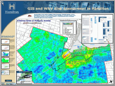
Summary map of the "heavy
surveillance model."
The data sources used for the surveillance model include:
- Larval surveillance in puddles and standing water using iPAQs;
- Complaint surveillance (people calling in or providing information to an on-line application);
- Bird surveillance (again from call-ins and the Internet); and
- Trapped mosquitoes by date and species (different species have priorities in the fight against West Nile Virus).
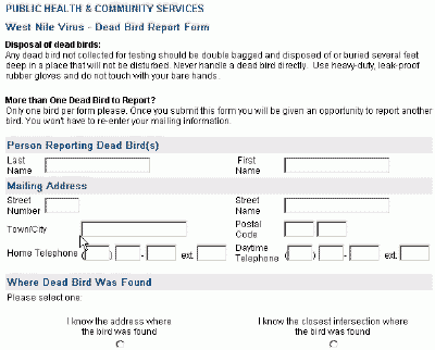
Web interface used to
capture information about dead birds.
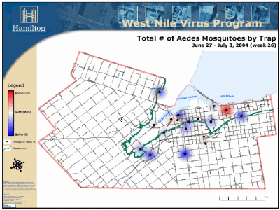
Presence of Aedes mosquitoes
by week.
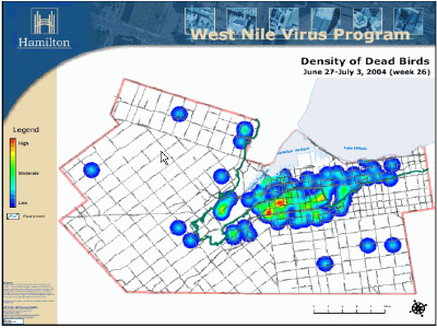
Density of dead birds
by week.
All of these are mapped individually, and finally combined to generate the first map shown above.The process is far more complicated than is indicated here.Bottom line is that "we wish we had infinite resources, but we don't, so we have to focus our efforts, and these maps help us do that," said MacDonald.
The second GIS-enabled application provides for modeling likely water-holding depressions on city owned or leased properties and monitoring them for the presence of West Nile Virus. This is an important application, because with 60% of the city being rural, there is a high potential for breeding ground in standing water.The project combined orthophotos and digital elevation models - which the city already had acquired for other purposes and were part of the corporate database - to generate a continuous surface model.They found the "bowls," or depressions, and generated polygons of them.These depressions were then ground-truthed to establish whether the model was offering reasonable results, which it was.
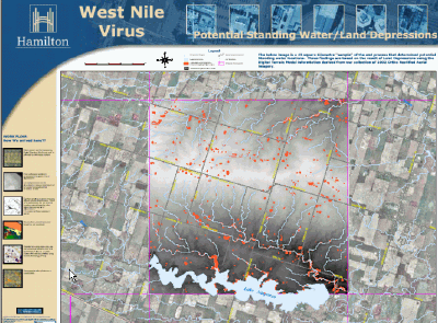
Potential standing water
model.
These polygons were then used to prioritize areas that needed further monitoring - again, given limited resources, the city needed to find a way to maximize their mitigation efforts.First they were compared to soils (e.g.sand drains water away while clay holds water).Second, they determined whether the depressions were on city owned or leased land.Mitigation can only be performed by the city on land it controls, but MacDonald indicated that by being aggressive where they could, they offered a valuable example to other landowners. So if conditions were right (a depression existed, it was on land that likely holds water, and it's controlled by the city), personnel were sent out to monitor whether mosquitoes were breeding in an area that was right for West Nile Virus.If so, they treated the area.
Again, this is a vast oversimplification of the painstaking scientific effort that went into the modeling described in both these applications, but a key point is that City personnel could undertake these efforts without having to back up and acquire data and get organized around using it within their environment.It's a good example of how data and processes were in place to allow critical spatial analyses to be carried out without much incremental cost, as alluded to by Little.
Combating West Nile Virus is getting a lot of headlines these days, but this article is less about the processes these folks undertook to do so than it is about the fact that they were ready to respond to this analytical need because of the homework they had done on their corporate GIS, and continue doing.If your job involved West Nile Virus mitigation, and you need to know more about the actual science behind these presentations, you are invited to contact James Rickert, at jrickert@hamilton.ca.
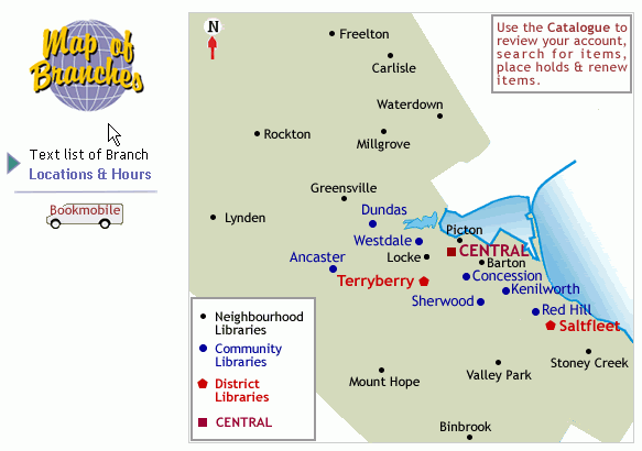
The Library project is just as exciting, albeit a lesser headline grabber with respect to life and death consequences.The City of Hamilton underwent a major boundary update, as seven smaller municipalities amalgamated to form a larger city.Of course this amalgamation had major ramifications in terms of providing municipal services, with the library function being one of these.The application we're showing here is a "proof of concept" application that will undergo quite a bit of change before it is finalized, but what it does is support analysis related to optimizing the library network that resulted from combining three municipal library systems.
Click image for larger
view.
I think that we could probably all agree that the Hamilton Public Library system has priorities higher than maintaining a GIS for network analysis, and so here's a good example of how a "have not" department could "have" GIS analysis because of the way the corporate program is structured.Helen Benoit, Director of Children and Young Adult Services, and Kit Darling, Director of Information Technology and Bibliographic Services, joined us during the WebEx to talk about the challenge of optimizing a historic network involving three established systems and merging them into one.According to Benoit, "This gives us a whole picture of what's involved in taking all these physical locations and needing to make decisions about siting facilities, looking at gaps and overlaps in the service." For business geographers, you'll recognize this as a retail network optimization exercise involving a merger of two or more banking systems, for example.
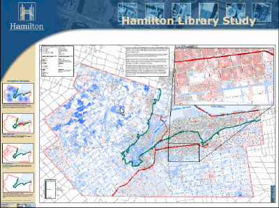
Map used to summarize
issues related to library network optimization.
Naturally, the City of Hamilton is not in a position to simply modify large chunks of its library network system in one go, but this tool will help them with a long-term master plan as leases terminate and space becomes available.The analysis includes considerations such as population density, natural barriers, the existing network, locations of social housing (subsidized housing), and land use (residential vs.industrial).This all plays into a network system with five classifications of libraries, ranging from two categories of neighborhood libraries to community branches, district libraries and finally the central branch.
Originally, the project worked with 2.5 km."catchments" for each library.Now that v1.0 of the project has been completed, the people involved realize that's the variable most in need of modification, as catchment distance will vary widely based on how rural or urban an area is.But the City of Hamilton's corporate GIS will allow them to play those sorts of "what if" games at a cost that the library system can afford.
So, what does a rockin' corporate GIS do for an encore as it continues to smoothly address need after need? Flick on your lighters - it wins awards...A not very thorough search of honors garnered includes these GIS industry grammies and tonies.
- A GeoSpatial World 2004 award for the library application in the "Innovative Raster Analysis" category
- A GITA Excellence Award in 2004 in Public Sector/Local Government
- Two URISA-ON (Ontario) awards in 2003, one for their publicly accessibly Internet mapping application and one for a map gallery contest entry
- Two map awards at GeoSpatial World 2003
- Directions Magazine's 2003 Web Mapping Contest winner in the Government category