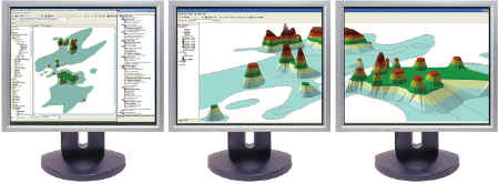
At AutoDesk U, Matrox had a booth with three 19-inch LCD monitors on the same computer.Naturally they were arranged in a semi-circle so you felt as though you were right inside the images on the screens.Of course, just to make the latest in video comparison, there was also a wide aspect ratio 22 inch LCD showing resolution of 3840 by 2400 - 32 bit true color. At that level it is so clear, that it could have been a window into the next booth.
Today we expect audio to be in stereo with multiple speakers, and most of use are still trying to get email, instant messaging, our internet browser in addition to whatever program we are actually doing work on all to display on some minimal 17 inch monitor.We have accepted trying to get 10 pounds on a 5-pound screen as the way things are.
Things are not that way and if you do mapping or graphics and look at large datasets, they won't all fit well on one monitor.Cost used to be a consideration, but if you went cheap and found one more "17-incher" like you have now and add a Matrox card you are well under $500, probably less.
What do you gain? More space to see better what you are doing, a lot faster and the ability do more in the same amount of time.The ability to see the same thing at different zoom levels, if it is in 3-D, you can see it rotated as multiple images, all at the same time.
Another obvious thing, CAD and imagery folks have been using fast graphics cards for years.We in Business Geography generally accept what comes with the computer.If you are waiting for graphics to paint, (remember when you tried to show street centerlines at the state level?), it is time to get in the fast graphic card mode.
If you look at the future at all, certainly three monitors are better than two or one, but how about six? The truth is, after the first three, three more monitors are just another card away.How cool would that be, three stacked on top of three.Since we are in the 21st century, Matrox has a simple setup software that allow you to configure which monitors show what and in what order.
3-D is here in mapping, imagery is already here, multiple datasets and data sources have been here, and the line between maps on the web and maps on the desktop is blurred.How do you see it all on one tiny screen? You just can't.
I use a metaphor that when something is really small you can only see it with one eye at a time.If it is big, it takes both eyes to look at. At the very least, we should have one monitor for each eye.
