In 1984, a colleague of mine at the EROS
Data Center in Sioux Falls, South Dakota produced one of the first
integrated image maps of digital geologic data with 30 Arc-second
digital elevation model (DEM) data.Larry Batten (now with ESRI),
working with software development colleagues who in my opinion were
true geniuses given the programming languages of the time, went on to
produce a complete digital model of the Black Hills region in western
South Dakota with hydrology, geology, and Landsat Thematic Mapper
satellite imagery.(Bibliography here.)
In the early 1980's, Batten did not have the benefits of large archives of digital data.If you needed a map of the geology in digital form, you digitized it yourself using the 7.5 minute U.S.Geological Survey (USGS) quadrangle maps.This painstakingly long process was repeated several times in order to stitch together the model of a large area.Fortunately, at that time, the DEM data were available on magnetic tape and the Interactive Digital Image Manipulation System (IDIMS) was a workhorse for integrating raster data types.Hence, the function to merge raster data was relatively straightforward provided somebody was writing the code to create that function, as the software developers at EROS were doing constantly.
The results were rewarding because they produced both hill-shaded and three-dimensional perspective views of a large area which were truly spectacular...for the time.Back in the 80's, as geologists, we were still working with line printer output and Landsat satellite data with 80 meter resolution in photographic format.When Landsat data were merged with the DEM data, the resulting image provided a vast visual improvement over the limited two-dimensions we were using at the time. But nobody but us could use it.The results were reported in obscure internal papers or at even more obscure conferences.
More data online...finally
Fast forward about twenty years and The National Map (preceded some years by TerraServer Digital Ortho Quads, DOQs) comes online .Finally, the data warehouses of the USGS are viewable by many.High resolution aerial photography, geology, stream data, geographic names and places, and other ancillary data are now viewable.The advent of the Geospatial One-Stop (GOS) supports the search capabilities of an even vaster archive of digital data.In total, the collective resources of the U.S.government are now available where once before, they were "slightly" less accessible.
These initiatives of the USGS "float the boat" of our profession, advancing both the knowledge and understanding of the applications of geospatial technology.
Gut Punch
So, why did it take a Google Earth (GE) "gut punch" to instill a "kid-like" enthusiasm for maps and geography? My 19-year old son spent hours last week on GE."Man this is fun going to places I've always wanted to see," he said to me.And that's just one data point.I'm sure you have similar experiences.
Let's do a brief comparison.Go to The National Map Viewer and search on for the "Black Hills, South Dakota." You can't...you have to know where it is.And when you get there, the legend is a bit quirky in terms of displaying data.There is no priority layering and the index maps need to be turned off to view some of the real data.Now go to GOS 2 and search on the "Black Hills." The results will be disappointing.I wanted to see the archives of all the work done in the region.Even refining the search to "geology of Black Hills" did not yield any better results.
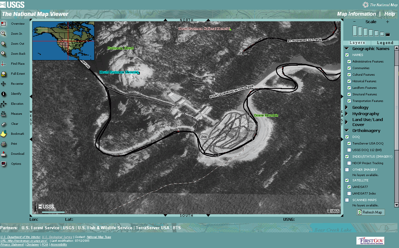
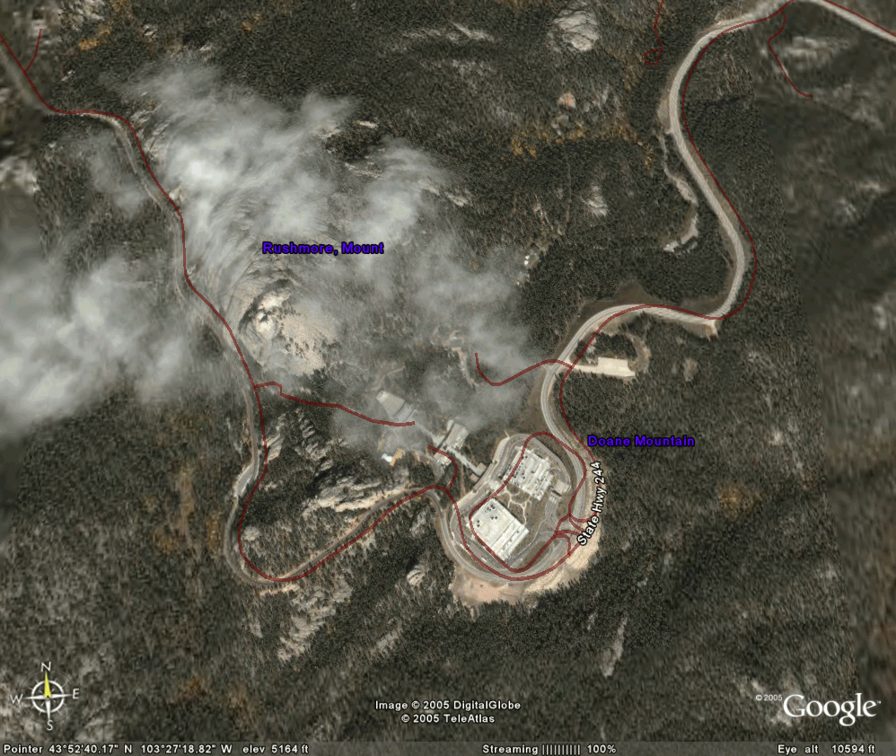
The screen shots below are a side by side comparison of some data take from the Mount Rushmore area using both The National Map Viewer (Figure 1) and Google Earth (Figure 2).I suggest you go to each website because it some respects it is an unfair comparison (Note however, the overlay accuracy of the road network with aerial imagery is not very good on either.I would have suspected that The National Map could do better than Google).There is no ancillary data on Google Earth. There is much more at The National Map however, I was disappointed in the ability to display want I wanted.It takes too much time to get at the information and the screen refresh is slow (that's being kind).
What's next? Google Sub-Earth?
What is even more disappointing is that Google Earth trumps The National Map in ease of use and visualization capabilities.The integration of digital elevation data and the ability to tilt, pan, zoom (See Figure 3 below)...and to do it very fast...should be an affront to our geospatial friends at the USGS. What's next from Google? Putting the entire archive of digital geologic data and integrating it with the DEM data? Soon we'll have subsurface seismic data as well.We'll call it Google Sub-Earth and we'll all soon be drilling for oil in our back yards."Excuse me neighbor, I noticed that you're drilling for oil in your backyard...were you using Google's Sub-Earth feature with enhanced seismic stratigraphic interpretation? I'd like to borrow that drill when you're done."
To be sure, Google and its variations, Earth and Map, soon to be confronted with competitors from Yahoo, Microsoft and MapQuest, "floats the boat" in so many ways with so many possibilities that it gets us all thinking about new applications.I have been waiting for 15 years for the catalyst that will drive geospatial data and applications deeper into enterprise computing.Will we see Google's map viewing capabilities married to an Oracle spatial database? Will we see supply chain managers using Microsoft's Virtual Earth (MS VE) to manage vast networks of inventory and distribution? Can we expect to see marketing managers using Google to learn where customers are coming from to view their website material, as in this application described by WebProNews.I suspect we will see all of those things, and all the data now held by the USGS may soon come to life in more vivid ways than what we now have with GOS or other geospatial data portals, like NASA's World Wind.We can only hope so, because these data warehouses aren't doing us any good if we can't use them and the USGS is not doing a great job of marketing their availability.
Next week, Directions Magazine unveils a new publication to follow the trends in "profiting" from location technology and the applications of how geospatial information and technology become more embedded in enterprise systems.Location Intelligence Magazine will be a window into not only how businesses will deploy these tools for B2B solutions but also how these "consumer" applications of GE and MS VE might affect how the business world leverage "location" for a competitive advantage. I hope you will subscribe.
In the early 1980's, Batten did not have the benefits of large archives of digital data.If you needed a map of the geology in digital form, you digitized it yourself using the 7.5 minute U.S.Geological Survey (USGS) quadrangle maps.This painstakingly long process was repeated several times in order to stitch together the model of a large area.Fortunately, at that time, the DEM data were available on magnetic tape and the Interactive Digital Image Manipulation System (IDIMS) was a workhorse for integrating raster data types.Hence, the function to merge raster data was relatively straightforward provided somebody was writing the code to create that function, as the software developers at EROS were doing constantly.
The results were rewarding because they produced both hill-shaded and three-dimensional perspective views of a large area which were truly spectacular...for the time.Back in the 80's, as geologists, we were still working with line printer output and Landsat satellite data with 80 meter resolution in photographic format.When Landsat data were merged with the DEM data, the resulting image provided a vast visual improvement over the limited two-dimensions we were using at the time. But nobody but us could use it.The results were reported in obscure internal papers or at even more obscure conferences.
More data online...finally
Fast forward about twenty years and The National Map (preceded some years by TerraServer Digital Ortho Quads, DOQs) comes online .Finally, the data warehouses of the USGS are viewable by many.High resolution aerial photography, geology, stream data, geographic names and places, and other ancillary data are now viewable.The advent of the Geospatial One-Stop (GOS) supports the search capabilities of an even vaster archive of digital data.In total, the collective resources of the U.S.government are now available where once before, they were "slightly" less accessible.
These initiatives of the USGS "float the boat" of our profession, advancing both the knowledge and understanding of the applications of geospatial technology.
Gut Punch
So, why did it take a Google Earth (GE) "gut punch" to instill a "kid-like" enthusiasm for maps and geography? My 19-year old son spent hours last week on GE."Man this is fun going to places I've always wanted to see," he said to me.And that's just one data point.I'm sure you have similar experiences.
Let's do a brief comparison.Go to The National Map Viewer and search on for the "Black Hills, South Dakota." You can't...you have to know where it is.And when you get there, the legend is a bit quirky in terms of displaying data.There is no priority layering and the index maps need to be turned off to view some of the real data.Now go to GOS 2 and search on the "Black Hills." The results will be disappointing.I wanted to see the archives of all the work done in the region.Even refining the search to "geology of Black Hills" did not yield any better results.
The screen shots below are a side by side comparison of some data take from the Mount Rushmore area using both The National Map Viewer (Figure 1) and Google Earth (Figure 2).I suggest you go to each website because it some respects it is an unfair comparison (Note however, the overlay accuracy of the road network with aerial imagery is not very good on either.I would have suspected that The National Map could do better than Google).There is no ancillary data on Google Earth. There is much more at The National Map however, I was disappointed in the ability to display want I wanted.It takes too much time to get at the information and the screen refresh is slow (that's being kind).
 |
 |
| Figure 1.The National Map Viewer (Click for
larger image) |
Figure 2.Google Earth (Click for larger image) |
What's next? Google Sub-Earth?
What is even more disappointing is that Google Earth trumps The National Map in ease of use and visualization capabilities.The integration of digital elevation data and the ability to tilt, pan, zoom (See Figure 3 below)...and to do it very fast...should be an affront to our geospatial friends at the USGS. What's next from Google? Putting the entire archive of digital geologic data and integrating it with the DEM data? Soon we'll have subsurface seismic data as well.We'll call it Google Sub-Earth and we'll all soon be drilling for oil in our back yards."Excuse me neighbor, I noticed that you're drilling for oil in your backyard...were you using Google's Sub-Earth feature with enhanced seismic stratigraphic interpretation? I'd like to borrow that drill when you're done."
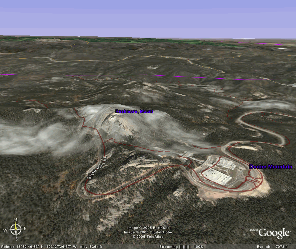 |
| Figure 3.Google Earth - 3-d perspective view of Mt.Rushmore area (Click for larger image) |
To be sure, Google and its variations, Earth and Map, soon to be confronted with competitors from Yahoo, Microsoft and MapQuest, "floats the boat" in so many ways with so many possibilities that it gets us all thinking about new applications.I have been waiting for 15 years for the catalyst that will drive geospatial data and applications deeper into enterprise computing.Will we see Google's map viewing capabilities married to an Oracle spatial database? Will we see supply chain managers using Microsoft's Virtual Earth (MS VE) to manage vast networks of inventory and distribution? Can we expect to see marketing managers using Google to learn where customers are coming from to view their website material, as in this application described by WebProNews.I suspect we will see all of those things, and all the data now held by the USGS may soon come to life in more vivid ways than what we now have with GOS or other geospatial data portals, like NASA's World Wind.We can only hope so, because these data warehouses aren't doing us any good if we can't use them and the USGS is not doing a great job of marketing their availability.
Next week, Directions Magazine unveils a new publication to follow the trends in "profiting" from location technology and the applications of how geospatial information and technology become more embedded in enterprise systems.Location Intelligence Magazine will be a window into not only how businesses will deploy these tools for B2B solutions but also how these "consumer" applications of GE and MS VE might affect how the business world leverage "location" for a competitive advantage. I hope you will subscribe.
From Our Homepage
Saying Farewell to an Amazing Journey
Communicating with Maps
Is There a GIS Career Ladder?
What does it mean to be geospatially smart? Series
Ways Real Estate and Property Developers Utilize Melissa GeoData for Data-Driven Decisions
Unlocking Value From Daily Satellite Imagery and Insights
Maximizing the Value of Your Address Data with Geo Addressing
How Indoor Mapping Enhances the Security of Smart Buildings
Look Ahead: AI, Location Intelligence and Efficiency
Collaboration Takes on Sea Level Rise & Dynamic Technology Environments
Brownies for Brownfields
Has Everything Been Mapped Already?
How Is Data Literacy Changing in an Artificial Intelligence Landscape
Portfolios for GIS Professionals: More Than Just Maps
How to Create a Distance Matrix in QGIS - A Step-by-Step Guide
7 Ideas for Bringing GIS into the K-12 Classroom
The Geography of Movement