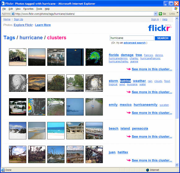
August 29, 2005, 4:37 PM: An emergency responder wants
to know the latest information on Hurricane Katrina.She calls her
imagery portal, keys in "Hurricane," and is presented with clusters of
images, one of which contains the tag "Katrina." The responder follows
the link and finds all recent imagery of the ongoing event.
Unfortunately, all these are just photos without detailed geospatial
content since she was using flickr.(See Figures 1 and 2).
What if geospatial information could be searched as easily? We believe this can be done in a way that complements current geospatial metadata and cataloguing standards.
Geospatial Taxonomy
The Federal Geographic Data Committee (FGDC) has been working on spatial metadata standards for over 10 years to facilitate the creation of a National Spatial Data Infrastructure (NSDI). SDIs are a federated mechanism to organize geospatial information, making it searchable, shareable and therefore more useful and relevant for all stakeholders - producers and users.
To accomplish this task, and others, FGDC has developed a Content Standard for Digital Geospatial Metadata (CSDGM).The standard provides a common set of terminology and definitions for the documentation of digital geospatial data.
The Open Geospatial Consortium's (OGC's) Geospatial Semantic Web initiative also is a plan to simplify the search for geospatial data.As a result, everyone expects geospatial data to be effectively catalogued, discoverable and accessible.Adoption of these standards has been slow in coming.Some will argue that the framework and standards are becoming more complex and even harder to apply, further slowing adoption.
Folksonomy
Creating usable structured repositories of knowledge can be a daunting task.We only need to consider the amount of geospatial content being generated since the surge in digital sensors, digital mapping cameras and LiDAR, to name a few.Thanks to Google Earth, Microsoft's Virtual Earth and other mainstream portals, users are now becoming aware of the availability and potential uses of geospatial information.They are trying to use geospatial information as simply as they do everything else in the Web.A recent paper by Ulises Mejias explains that we have arrived at a point where the amount of content published far exceeds the ability of anyone to categorize and index it.
As this is not a problem exclusive to geospatial information, it is interesting to look around for some clues on how other communities, particularly the Internet community, are addressing this challenge.A few years back Thomas Vander Wal coined the term Folksonomy, or "classification by the people." The idea is that content could be structured by ad-hoc groups of people cooperating to organize the information into categories.It could be argued that the current FGDC efforts to create a spatial data infrastructure fall into the category of the more traditional Scientific Taxonomy. Folksonomy can be implemented via social computing.More particularly, collaborative software, which becomes more valuable as more people use it.
Let's discuss one Web application that employs the power of collaboration to organize vast amounts of imagery.The photo sharing site, flickr, allows users to organize their photo collections via tags, keywords assigned to each photo, and sets, albums that allow photos to be viewed in a particular order.Also, flickr enables users to organize themselves into special interest groups where photos can be shared as pools, or collaborative albums.Groups can have specific rules on how tagging needs to occur to facilitate sharing and discovering photos.Groups also encourage users to comment on individual photos, select favorites or add notes.
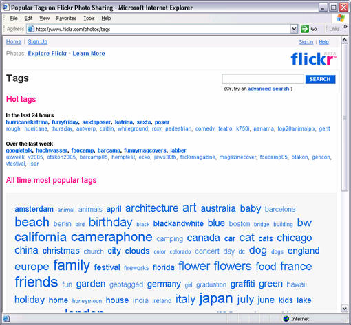
Tagging, annotation and commenting produce a wealth of metadata that is mined by flickr to enhance the discovery of its ever-growing photo archive.A flickr user can always see what tags are hot or popular in the public collection (Figure 3) or in group pools.Tags then can be used to locate similar photos, and through the use of clusters, can help navigate an otherwise highly unstructured content repository.
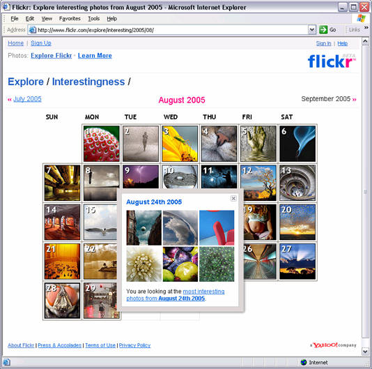
One of the most intriguing results of this metadata mining is what
flickr calls the interestingness
ranking.flickr has an algorithm that
analyzes click-throughs, comments and tags to determine which photos
are more interesting to a human.The results are quite spectacular
(Figure 4).
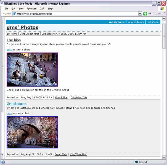
Finally, flickr users can subscribe to groups or even other users via
Real Simple Syndication (RSS) feeds (Figure 5), and receive automatic
updates when peers upload new images.
Other examples of Folksonomy are del.icio.us
and technorati, which
allow users to tag specific Web pages or blog entries for future
reference.Tags can then be mined by other users to locate relevant
information.Google uses an alternative approach by ranking Web content
based upon who
links to the content.The ranking uses the intrinsic
value of references to find out which content on the web is
"interesting."
Applying Folksonomy to Spatial Data Infrastructures
We believe Folksonomy can be applied to use the power of user communities to increase the organization, searchability and usability of geospatial information.
Integrating current standard metadata approaches with a user-driven Folksonomy engine could create a new kind of geospatial information data infrastructure.In that case, the scenario presented at the beginning of this article could look like this:
July 12, 2006, 2:37 PM: An emergency responder needs the latest information on Hurricane Jake.She calls her geospatial portal, keys in "Hurricane" and is presented with clusters that include maps, images and weather data.One of which contains the tag "Jake." She follows the link and finds all relevant base maps, recent imagery and weather data of the ongoing event.She is also presented with available geospatial RSS feeds.
She tags the relevant data sources to make it easy for her and her team to locate the information in the future.She also subscribes to relevant RSS feeds to receive automatic notifications when new data is available.As this portal is integrated with her desktop applications, she is able to use the information she needs right away.
Now that's a geospatial information search!
 |
 |
| Figure 1.(Click for larger
image) |
Figure 2 (Click for larger image) |
What if geospatial information could be searched as easily? We believe this can be done in a way that complements current geospatial metadata and cataloguing standards.
Geospatial Taxonomy
The Federal Geographic Data Committee (FGDC) has been working on spatial metadata standards for over 10 years to facilitate the creation of a National Spatial Data Infrastructure (NSDI). SDIs are a federated mechanism to organize geospatial information, making it searchable, shareable and therefore more useful and relevant for all stakeholders - producers and users.
To accomplish this task, and others, FGDC has developed a Content Standard for Digital Geospatial Metadata (CSDGM).The standard provides a common set of terminology and definitions for the documentation of digital geospatial data.
The Open Geospatial Consortium's (OGC's) Geospatial Semantic Web initiative also is a plan to simplify the search for geospatial data.As a result, everyone expects geospatial data to be effectively catalogued, discoverable and accessible.Adoption of these standards has been slow in coming.Some will argue that the framework and standards are becoming more complex and even harder to apply, further slowing adoption.
Folksonomy
Creating usable structured repositories of knowledge can be a daunting task.We only need to consider the amount of geospatial content being generated since the surge in digital sensors, digital mapping cameras and LiDAR, to name a few.Thanks to Google Earth, Microsoft's Virtual Earth and other mainstream portals, users are now becoming aware of the availability and potential uses of geospatial information.They are trying to use geospatial information as simply as they do everything else in the Web.A recent paper by Ulises Mejias explains that we have arrived at a point where the amount of content published far exceeds the ability of anyone to categorize and index it.
As this is not a problem exclusive to geospatial information, it is interesting to look around for some clues on how other communities, particularly the Internet community, are addressing this challenge.A few years back Thomas Vander Wal coined the term Folksonomy, or "classification by the people." The idea is that content could be structured by ad-hoc groups of people cooperating to organize the information into categories.It could be argued that the current FGDC efforts to create a spatial data infrastructure fall into the category of the more traditional Scientific Taxonomy. Folksonomy can be implemented via social computing.More particularly, collaborative software, which becomes more valuable as more people use it.
Let's discuss one Web application that employs the power of collaboration to organize vast amounts of imagery.The photo sharing site, flickr, allows users to organize their photo collections via tags, keywords assigned to each photo, and sets, albums that allow photos to be viewed in a particular order.Also, flickr enables users to organize themselves into special interest groups where photos can be shared as pools, or collaborative albums.Groups can have specific rules on how tagging needs to occur to facilitate sharing and discovering photos.Groups also encourage users to comment on individual photos, select favorites or add notes.
Tagging, annotation and commenting produce a wealth of metadata that is mined by flickr to enhance the discovery of its ever-growing photo archive.A flickr user can always see what tags are hot or popular in the public collection (Figure 3) or in group pools.Tags then can be used to locate similar photos, and through the use of clusters, can help navigate an otherwise highly unstructured content repository.
 |
 |
 |
Applying Folksonomy to Spatial Data Infrastructures
We believe Folksonomy can be applied to use the power of user communities to increase the organization, searchability and usability of geospatial information.
- Enabling tags and pools of geospatial information would empower individual users to quickly extend the geospatial metadata with immediate feedback.Groups working on specific projects (Hurricane Katrina, for example) would converge faster to the best datasets.
- Geospatial projects or geoworkspaces reference geospatial layers and images, thus providing information that could be used to rank geospatial content.
- Folksonomies based on actual use and need by users would eventually provide a wealth of data that could complement FGDC metadata, as well as suggest changes in its taxonomy structure to accommodate mainstream trends.
- RSS feeds could also be enabled to allow users to subscribe to geospatial information feeds to match their interests and needs for particular projects.This would be a great application for the geospatial RSS standard being developed.
- Geospatial search engines should be developed incorporating both traditional FGDC Taxonomy and Folksonomy derived metadata to simplify user queries.A well-designed Folksonomy system could automatically mine the metadata to provide the most relevant or interesting content.Finding the right geospatial data could start and end with a simple query such as "Hurricane Katrina."
Integrating current standard metadata approaches with a user-driven Folksonomy engine could create a new kind of geospatial information data infrastructure.In that case, the scenario presented at the beginning of this article could look like this:
July 12, 2006, 2:37 PM: An emergency responder needs the latest information on Hurricane Jake.She calls her geospatial portal, keys in "Hurricane" and is presented with clusters that include maps, images and weather data.One of which contains the tag "Jake." She follows the link and finds all relevant base maps, recent imagery and weather data of the ongoing event.She is also presented with available geospatial RSS feeds.
She tags the relevant data sources to make it easy for her and her team to locate the information in the future.She also subscribes to relevant RSS feeds to receive automatic notifications when new data is available.As this portal is integrated with her desktop applications, she is able to use the information she needs right away.
Now that's a geospatial information search!
From Our Homepage
Saying Farewell to an Amazing Journey
Communicating with Maps
Is There a GIS Career Ladder?
What does it mean to be geospatially smart? Series
Ways Real Estate and Property Developers Utilize Melissa GeoData for Data-Driven Decisions
Unlocking Value From Daily Satellite Imagery and Insights
Maximizing the Value of Your Address Data with Geo Addressing
How Indoor Mapping Enhances the Security of Smart Buildings
Look Ahead: AI, Location Intelligence and Efficiency
Collaboration Takes on Sea Level Rise & Dynamic Technology Environments
Brownies for Brownfields
Has Everything Been Mapped Already?
How Is Data Literacy Changing in an Artificial Intelligence Landscape
Portfolios for GIS Professionals: More Than Just Maps
How to Create a Distance Matrix in QGIS - A Step-by-Step Guide
7 Ideas for Bringing GIS into the K-12 Classroom
The Geography of Movement