FortiusOne is
the company behind GeoCommons,
a "common place" to share data, and soon, to make maps. GeoCommons'
first application, "Finder!,"
released just a year ago, is an app designed to host, convert and share
public datasets. The promise beyond Finder! - its "better half" - is an
app called "Maker!" that provides tools to make maps from these shared
data sources. FortiusOne announced an October 1 release date for Maker!
at the Web 2.0 Expo on Sept. 18 in New York.
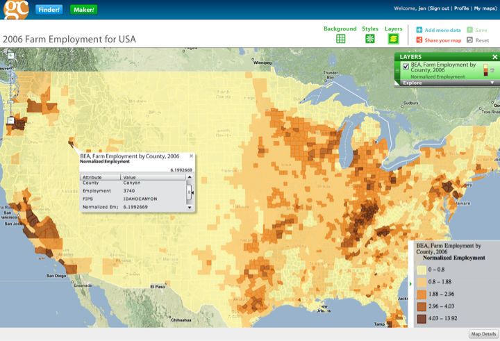
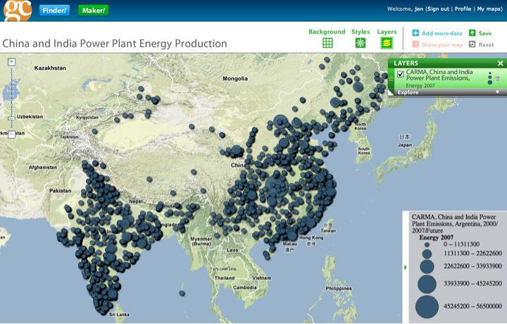
Sean Gorman, FortiusOne's CEO, previewed Maker! for me last week. In short, "Wow!" Maker! is an application that provides not only the key tools for anyone to make a "color coded" map, but also the guidance to make a "good" (cartographically effective) map. I use the term "color coded" to highlight that while this app will likely be very popular with those trained in geography and cartography, it's aimed at less experienced users as well. Thus the term "choropleth" does not appear. And while there are histograms, users need not select "quartile" or "natural breaks" to divvy up the data, but rather "pick the picture" that best matches the provided picture of the data distribution.
Users can open saved maps or create their own based on datasets uploaded to Finder! in Keyhole Markup Language (KML), comma separated (csv) and shapefile formats. Making a map is a four-step, wizard-driven process. That "wizard" is called Map Brewer and is the first app built on Maker! (FortiusOne uses its existing API to create these add-on apps and plans, in time, to make it available for third party developers.) The user walks through elegant panels to select the variable to map, the symbology ("color or size"), data classification and color preferences. Each panel provides guidance and detailed help. Even more exciting, selecting an option immediately previews it on the map, so map makers know instantly if they are heading down the correct path.
Among the options in the four panels is one to select a Google, Microsoft or Yahoo background for the map, or use none at all (the datasets of interest appear on a solid color background). More experienced or brave users can develop custom thematics and categorize data by hand. Maps can be saved into a user account, available for all to see. Users can share links to maps and in time will be able to use embedded code to place them on websites and blogs. Printing options beyond "print screen" are not available in this first release, but are in the queue for the future. That said, maps can be outputted as shapefiles or KML and be brought into other apps for further analysis and printing. Also planned for the future: support for real-time data (GeoRSS, dynamic KML). Technology for that application will come from FortiusOne's recent acquisition of Mapufacture.
What's the technology behind Maker!? FortiusOne worked with Stamen and tapped into its open source Modest Maps platform. Axis Maps built Map Brewer and the Map Brewer name came from the company's previous work on Color Brewer. FortiusOne undertook quite a bit of testing to ensure that experienced and inexperienced users could make sense of the user interface and create effective and useful maps. For now, the service runs on FortiusOne's own co-located servers, but the company is exploring moving to the commercial cloud. Recently, staffers have tested Amazon's and Engine Yard's solutions.
The GeoCommons business model will involve a for fee service for users who want to use private data and create private maps. There will also be the option, in time, to pay for non-public domain data from third party data providers for use in Maker!.
FortiusOne offers a full user guide and videos to explain the different features. It's clearly working hard to ensure that Maker! is usable by a range of map makers. The company had a great tester not long ago. ABC's Bob Woodruff came by for a look. Far from a technical user (Gorman noted Woodruff was not sure what to do with a Zip file), he "got it." Who knows, we may see Maker! on Woodruff's "Focus Earth with Bob Woodruff" on Planet Green.
I encourage geospatial users - professional, casual and academic - to look to Maker! to both create maps and explore its implementation. What you will see is an elegant online interface, use of existing APIs from Google and Microsoft, tools to educate about maps and mapping, and an interesting experiment that allows free mapping of your data only if you share both your data and your maps. Maker! is admittedly a "standing on the shoulders of giants" implementation, but what's been done here towers over every online mapping implementation aimed at non-technical users that I've seen.
Sean Gorman, FortiusOne's CEO, previewed Maker! for me last week. In short, "Wow!" Maker! is an application that provides not only the key tools for anyone to make a "color coded" map, but also the guidance to make a "good" (cartographically effective) map. I use the term "color coded" to highlight that while this app will likely be very popular with those trained in geography and cartography, it's aimed at less experienced users as well. Thus the term "choropleth" does not appear. And while there are histograms, users need not select "quartile" or "natural breaks" to divvy up the data, but rather "pick the picture" that best matches the provided picture of the data distribution.
Users can open saved maps or create their own based on datasets uploaded to Finder! in Keyhole Markup Language (KML), comma separated (csv) and shapefile formats. Making a map is a four-step, wizard-driven process. That "wizard" is called Map Brewer and is the first app built on Maker! (FortiusOne uses its existing API to create these add-on apps and plans, in time, to make it available for third party developers.) The user walks through elegant panels to select the variable to map, the symbology ("color or size"), data classification and color preferences. Each panel provides guidance and detailed help. Even more exciting, selecting an option immediately previews it on the map, so map makers know instantly if they are heading down the correct path.
 |
 |
Among the options in the four panels is one to select a Google, Microsoft or Yahoo background for the map, or use none at all (the datasets of interest appear on a solid color background). More experienced or brave users can develop custom thematics and categorize data by hand. Maps can be saved into a user account, available for all to see. Users can share links to maps and in time will be able to use embedded code to place them on websites and blogs. Printing options beyond "print screen" are not available in this first release, but are in the queue for the future. That said, maps can be outputted as shapefiles or KML and be brought into other apps for further analysis and printing. Also planned for the future: support for real-time data (GeoRSS, dynamic KML). Technology for that application will come from FortiusOne's recent acquisition of Mapufacture.
What's the technology behind Maker!? FortiusOne worked with Stamen and tapped into its open source Modest Maps platform. Axis Maps built Map Brewer and the Map Brewer name came from the company's previous work on Color Brewer. FortiusOne undertook quite a bit of testing to ensure that experienced and inexperienced users could make sense of the user interface and create effective and useful maps. For now, the service runs on FortiusOne's own co-located servers, but the company is exploring moving to the commercial cloud. Recently, staffers have tested Amazon's and Engine Yard's solutions.
The GeoCommons business model will involve a for fee service for users who want to use private data and create private maps. There will also be the option, in time, to pay for non-public domain data from third party data providers for use in Maker!.
FortiusOne offers a full user guide and videos to explain the different features. It's clearly working hard to ensure that Maker! is usable by a range of map makers. The company had a great tester not long ago. ABC's Bob Woodruff came by for a look. Far from a technical user (Gorman noted Woodruff was not sure what to do with a Zip file), he "got it." Who knows, we may see Maker! on Woodruff's "Focus Earth with Bob Woodruff" on Planet Green.
I encourage geospatial users - professional, casual and academic - to look to Maker! to both create maps and explore its implementation. What you will see is an elegant online interface, use of existing APIs from Google and Microsoft, tools to educate about maps and mapping, and an interesting experiment that allows free mapping of your data only if you share both your data and your maps. Maker! is admittedly a "standing on the shoulders of giants" implementation, but what's been done here towers over every online mapping implementation aimed at non-technical users that I've seen.
From Our Homepage
Saying Farewell to an Amazing Journey
Communicating with Maps
Is There a GIS Career Ladder?
What does it mean to be geospatially smart? Series
Ways Real Estate and Property Developers Utilize Melissa GeoData for Data-Driven Decisions
Unlocking Value From Daily Satellite Imagery and Insights
Maximizing the Value of Your Address Data with Geo Addressing
How Indoor Mapping Enhances the Security of Smart Buildings
Look Ahead: AI, Location Intelligence and Efficiency
Collaboration Takes on Sea Level Rise & Dynamic Technology Environments
Brownies for Brownfields
Has Everything Been Mapped Already?
How Is Data Literacy Changing in an Artificial Intelligence Landscape
Portfolios for GIS Professionals: More Than Just Maps
How to Create a Distance Matrix in QGIS - A Step-by-Step Guide
7 Ideas for Bringing GIS into the K-12 Classroom
The Geography of Movement