The GEOINT Symposium,
a conference organized by the U.S. Geospatial Intelligence Foundation
(USGIF) and held Oct. 19-22 in San Antonio, underwent a major
transformation this year. The event's main technology exhibition, which
historically offered a broad suite of geospatial solutions, this year
particularly emphasized satellite imaging and specifically, the
exploitation of full motion video (FMV). While there has always been
some emphasis on satellite technology, GEOINT attracted those companies
that build the sensors that capture, process and store imagery. The
conference has now become the premier conference on remote sensing.
There was less of a focus on GIS and a great deal of emphasis on full
motion video. The plethora of unmanned airborne vehicles (UAVs) used by
the military and intelligence agencies has greatly increased the volume
of imagery being captured. The need to process real-time,
geo-referenced video was, for this year, a central and recurring theme.
While you can imagine the bandwidth necessary to stream a "live" video feed and the storage problems associated with that process, it's the "last mile" that is the real bottleneck for military and intelligence analysts: putting the video in context. Companies that are building solutions to process and catalog FMV are also designing tools to allow analysts to integrate chat logs, text annotation and other fragments of intelligence to give field commanders a complete picture of the operation. These intelligence fragments must also be searchable. So, while having the manpower necessary to watch every video clip captured may be impossible, searching the metadata associated with video is vital, not only to provide context but also to analyze changes to unfolding situations that would potentially raise a "red flag" with analysts.
Several companies demonstrated their FMV solutions at GEOINT. Intergraph demonstrated its Motion Video Exploitation solution (see Figure 1 below), which leverages technology from its existing Video Analyst product. All Points Blog reviewed Intergraph's solution this past June: "The basic operation is to take georegistered, full motion video and embed the video onto a map. This is not showing video in a separate window; this product actually 'fuses' the video onto a map. It brings DVR-like technology to support viewing and analyzing motion video from within [Intergraph's] GeoMedia environment. The user can annotate the video from reports; correlate annotations to the time of specific events." Intergraph uses technology provided by EchoStorm that supports "ingesting" video into Intergraph's geospatial solutions. Since Intergraph's forte is mapping, the company wanted to augment typical video playback by embedding the video within the map. Boeing's solution had excellent video search and cataloging capabilities. Boeing has also integrated video into a mapping platform, called DataMaster, and is able to drop in imagery in a 3-D visualization application, called Battlescape, which enables situational awareness. Harris Corporation demonstrated FAME or Full-Motion Video Asset Management Engine that provided functionality for incorporating a variety of voice/chat, text and other signal intelligence (SIGINT). Harris chose to focus on developing FAME as a system architecture. It allows a customizable solution for multiple intelligence inputs: signal, human, geospatial or otherwise.
Harris offers a solution to the problem of packaging real-time video for faster transmission. The company, which supplies technology to the broadcast media, is able to compress the video with mission data (such as telemetry, etc.) in an encoded format that complies with the Motion Imagery Standards Board (MISB). In September, Harris, Lockheed Martin and NetApp were awarded a contract under a project called "Valiant Angel," which will support the integration, exploitation and dissemination of video data collected from UAVs.
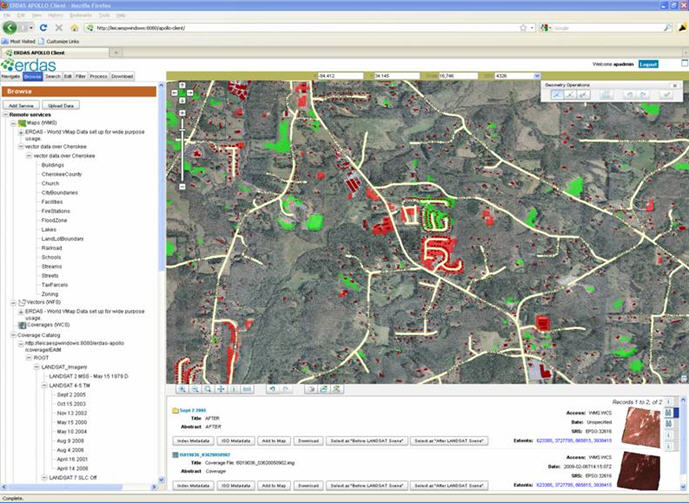
Both ITT VIS and ERDAS demonstrated recently announced product upgrades. ERDAS announced IMAGINE 2010, its complete solution for remote sensing image analysis and integrated GIS. The company also announced ERDAS APOLLO (see Figure 2 below), a Web Processing Service (WPS) that provides a workflow management solution for remote sensing analysts. The APOLLO catalog can support workflows, including model-building scenarios, between several ERDAS products such as ERDAS IMAGINE, ERDAS APOLLO Web Client (2D), and the ERDAS TITAN Viewer 3D virtual globe.
ITT VIS demonstrated ENVI 4.7, which integrates with ArcGIS. As reported in All Points Blog in July: "The 'Geolink' function within the product links ArcGIS to ENVI EX through a simple drag and drop method of exchanging data. Users can also pan and zoom around an area in side-by-side windows of ArcGIS or ENVI EX simultaneously."
If you're interested in how all of these data are stored and managed, consider NJVC's cloud computing solution developed with Appistry. NJVC's expertise is in managing data centers and Appistry brings its cloud computing solutions to the mix. The intelligence community requires optimum security, so this is one of the key issues often raised about a cloud architecture. The recently released white paper by NJVC explores more about how the company provides scalable and reliable systems in a private cloud environment.
Those who may have expected GEOINT to be totally focused on the military and intelligence were surprised by the opportunities to explore the latest trends in remote sensing, image processing and the ancillary technologies that support them. Those interested in remote sensing technology should make a point of attending the next GEOINT Symposium, October 25-28, 2010 in Nashville.
While you can imagine the bandwidth necessary to stream a "live" video feed and the storage problems associated with that process, it's the "last mile" that is the real bottleneck for military and intelligence analysts: putting the video in context. Companies that are building solutions to process and catalog FMV are also designing tools to allow analysts to integrate chat logs, text annotation and other fragments of intelligence to give field commanders a complete picture of the operation. These intelligence fragments must also be searchable. So, while having the manpower necessary to watch every video clip captured may be impossible, searching the metadata associated with video is vital, not only to provide context but also to analyze changes to unfolding situations that would potentially raise a "red flag" with analysts.
Several companies demonstrated their FMV solutions at GEOINT. Intergraph demonstrated its Motion Video Exploitation solution (see Figure 1 below), which leverages technology from its existing Video Analyst product. All Points Blog reviewed Intergraph's solution this past June: "The basic operation is to take georegistered, full motion video and embed the video onto a map. This is not showing video in a separate window; this product actually 'fuses' the video onto a map. It brings DVR-like technology to support viewing and analyzing motion video from within [Intergraph's] GeoMedia environment. The user can annotate the video from reports; correlate annotations to the time of specific events." Intergraph uses technology provided by EchoStorm that supports "ingesting" video into Intergraph's geospatial solutions. Since Intergraph's forte is mapping, the company wanted to augment typical video playback by embedding the video within the map. Boeing's solution had excellent video search and cataloging capabilities. Boeing has also integrated video into a mapping platform, called DataMaster, and is able to drop in imagery in a 3-D visualization application, called Battlescape, which enables situational awareness. Harris Corporation demonstrated FAME or Full-Motion Video Asset Management Engine that provided functionality for incorporating a variety of voice/chat, text and other signal intelligence (SIGINT). Harris chose to focus on developing FAME as a system architecture. It allows a customizable solution for multiple intelligence inputs: signal, human, geospatial or otherwise.
 |
Harris offers a solution to the problem of packaging real-time video for faster transmission. The company, which supplies technology to the broadcast media, is able to compress the video with mission data (such as telemetry, etc.) in an encoded format that complies with the Motion Imagery Standards Board (MISB). In September, Harris, Lockheed Martin and NetApp were awarded a contract under a project called "Valiant Angel," which will support the integration, exploitation and dissemination of video data collected from UAVs.
Both ITT VIS and ERDAS demonstrated recently announced product upgrades. ERDAS announced IMAGINE 2010, its complete solution for remote sensing image analysis and integrated GIS. The company also announced ERDAS APOLLO (see Figure 2 below), a Web Processing Service (WPS) that provides a workflow management solution for remote sensing analysts. The APOLLO catalog can support workflows, including model-building scenarios, between several ERDAS products such as ERDAS IMAGINE, ERDAS APOLLO Web Client (2D), and the ERDAS TITAN Viewer 3D virtual globe.
 |
ITT VIS demonstrated ENVI 4.7, which integrates with ArcGIS. As reported in All Points Blog in July: "The 'Geolink' function within the product links ArcGIS to ENVI EX through a simple drag and drop method of exchanging data. Users can also pan and zoom around an area in side-by-side windows of ArcGIS or ENVI EX simultaneously."
If you're interested in how all of these data are stored and managed, consider NJVC's cloud computing solution developed with Appistry. NJVC's expertise is in managing data centers and Appistry brings its cloud computing solutions to the mix. The intelligence community requires optimum security, so this is one of the key issues often raised about a cloud architecture. The recently released white paper by NJVC explores more about how the company provides scalable and reliable systems in a private cloud environment.
Those who may have expected GEOINT to be totally focused on the military and intelligence were surprised by the opportunities to explore the latest trends in remote sensing, image processing and the ancillary technologies that support them. Those interested in remote sensing technology should make a point of attending the next GEOINT Symposium, October 25-28, 2010 in Nashville.
From Our Homepage
Saying Farewell to an Amazing Journey
Communicating with Maps
Is There a GIS Career Ladder?
What does it mean to be geospatially smart? Series
Ways Real Estate and Property Developers Utilize Melissa GeoData for Data-Driven Decisions
Unlocking Value From Daily Satellite Imagery and Insights
Maximizing the Value of Your Address Data with Geo Addressing
How Indoor Mapping Enhances the Security of Smart Buildings
Look Ahead: AI, Location Intelligence and Efficiency
Collaboration Takes on Sea Level Rise & Dynamic Technology Environments
Brownies for Brownfields
Has Everything Been Mapped Already?
How Is Data Literacy Changing in an Artificial Intelligence Landscape
Portfolios for GIS Professionals: More Than Just Maps
How to Create a Distance Matrix in QGIS - A Step-by-Step Guide
7 Ideas for Bringing GIS into the K-12 Classroom
The Geography of Movement