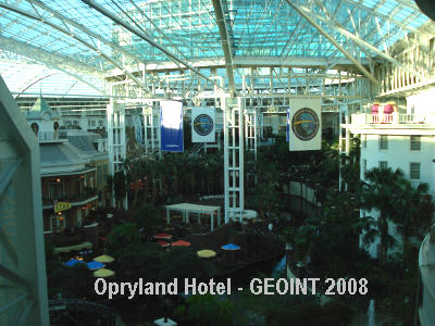
The larger defense contractors, including Ball
Aerospace, BAE Systems, SAIC, Harris, Northrop Grumman, Boeing and
Raytheon, held the majority of the floor space at the GEOINT
conference. It's hard to miss them. It's also hard to comprehend the
scope of their geospatial business. If you believe that geospatial
technology underpins the vast majority of the intelligence community
(IC) projects, then you can appreciate the investment these companies
are making as prime contractors for large government projects. The U.S.
Geospatial Intelligence Foundation (USGIF), the consortium organized to
address the IC business community and the host of this conference, has
done an incredible job of gathering the players together and producing
an event of this magnitude.
The government is moving to identify and segment the individual intelligence agencies into specific areas of expertise and functional management: GEOINT (geospatial), HUMINT (human intelligence; think CIA) and SIGINT (signal intelligence; think National Security Agency). The amendments to Executive Order 12333, signed on July 31, 2008 by President Bush, formalized the functions of specific agencies and gave all responsibility for geospatial technology and intelligence gathering to the director of the National Geospatial-Intelligence Agency (NGA).
As the consolidation of expertise and functional management grows, it is likely, even with the anticipated budget constraints, that geospatial technology will become a more recognized and certainly more valuable aspect of government intelligence gathering in the coming years. The growth of the GEOINT Symposium is a sign that geospatial technology, as a discipline, has come into its own.
On the Exhibit Floor
Microsoft - Microsoft unveiled its Single View Platform (SVP), a solution that offers users a "data visualization platform." It packages Virtual Earth, SharePoint, SQL Server and Windows Server (read more on our blog). The SVP, as explained by Microsoft, aims to more formally put hooks into these once separate tools and to offer a complete solution. Whereas you might have purchased each individually, Microsoft now wants you to consider the SVP as an enterprise solution that gives, in the parlance of many government and military organizations, the "common operating picture" or a "dashboard" in which to see a variety of intelligence information.
Microsoft is also integrating its business intelligence (BI) tools into SVP. Microsoft BI solutions are comprised of SQL Server, as well as solutions for data warehousing, extract transform and load (ETL), and online analytical process (OLAP) services. So, SVP offers integration with Virtual Earth to expose and map the underlying location components of an enterprise data warehouse.
My take is that Microsoft is repackaging the commercial off-the-shelf (COTS) software to combat what it perceives as a threat from the defense contractors. These larger contractors have the lion's share of the IC business and frequently bundle services and software as higher-priced customized services. If you want to see a demonstration of how SharePoint was married to Virtual Earth, take a look at the conducted by IDV Solutions, a Microsoft partner.
ITT - ITT is parlaying the exposure gained from developing and manufacturing the earth imaging system for GeoEye-1 and the growth of its ENVI image processing software into a complete, end-to-end remote sensing juggernaut. ENVI version 4.5, released some time ago, provides file sharing with ESRI's ArcGIS. Version 4.6 will be forthcoming in January 2009 with a Target Detection Wizard. The company also helped develop the sensor system for the .41-meter spatial resolution of GeoEye-1 and is now turning its attention to developing the next generation of platforms, which are expected to have .25 meter spatial resolution.
ITT is also moving toward Web services. Its Image Access Solutions (IAS) is comprised of streaming (JPIP) and compression technologies (JPEG 2000) to deliver imagery within an enterprise architecture through a Web feature service (WFS).
ObjectFX - ObjectFX, in the geospatial business since 1994, is currently focused on developing spatiotemporal applications. This integration of space and time has interesting applications in detecting unusual relationships for the purpose of threat detection. I saw a demo of how Object FX's rule-based system can filter the movement of ships over time and proximity to determine if contraband is being off-loaded. For example, if ships are in unusually close proximity to each other (less than 100 meters) at 3 a.m. in the middle of the Gulf of Mexico, something suspicious might be going on.
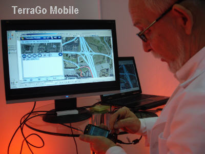
TerraGo Technologies - TerraGo demonstrated an integrated approach to taking vector, image and video data with partners ERDAS, Pictometry, Immersive Media and ESRI. The data are shared in the GeoPDF format. The unique aspect and greatest selling point of TerraGo products are their ability to capture information from such a wide variety of formats, cookie-cut the area and send it off in a geo-registered document that almost anyone can open, use and share.
Google - Google now has dedicated staff focused on enterprise solutions for federal and IC customers, as well as for state and local government. Having come from the intel community (i.e. Keyhole), it's strange that this wasn't a focus before.
Silicon Graphics Inc. - At one time, SGI was thought of as a hardware company that had incredible graphics technology. SGI today positions itself as a software company that can integrate many types of immersive visual environments into a single view. I saw a demo of an SGI solution that integrated Google Maps with video camera feeds swiped from the Tennessee Department of Transportation. It then oriented the map from several angles to give a variety of perspectives. It's called FusionVUE. I was impressed by the manipulation of the view from an iPhone, and vice-versa. They have a great online demo.
The government is moving to identify and segment the individual intelligence agencies into specific areas of expertise and functional management: GEOINT (geospatial), HUMINT (human intelligence; think CIA) and SIGINT (signal intelligence; think National Security Agency). The amendments to Executive Order 12333, signed on July 31, 2008 by President Bush, formalized the functions of specific agencies and gave all responsibility for geospatial technology and intelligence gathering to the director of the National Geospatial-Intelligence Agency (NGA).
 |
As the consolidation of expertise and functional management grows, it is likely, even with the anticipated budget constraints, that geospatial technology will become a more recognized and certainly more valuable aspect of government intelligence gathering in the coming years. The growth of the GEOINT Symposium is a sign that geospatial technology, as a discipline, has come into its own.
On the Exhibit Floor
Microsoft - Microsoft unveiled its Single View Platform (SVP), a solution that offers users a "data visualization platform." It packages Virtual Earth, SharePoint, SQL Server and Windows Server (read more on our blog). The SVP, as explained by Microsoft, aims to more formally put hooks into these once separate tools and to offer a complete solution. Whereas you might have purchased each individually, Microsoft now wants you to consider the SVP as an enterprise solution that gives, in the parlance of many government and military organizations, the "common operating picture" or a "dashboard" in which to see a variety of intelligence information.
Microsoft is also integrating its business intelligence (BI) tools into SVP. Microsoft BI solutions are comprised of SQL Server, as well as solutions for data warehousing, extract transform and load (ETL), and online analytical process (OLAP) services. So, SVP offers integration with Virtual Earth to expose and map the underlying location components of an enterprise data warehouse.
My take is that Microsoft is repackaging the commercial off-the-shelf (COTS) software to combat what it perceives as a threat from the defense contractors. These larger contractors have the lion's share of the IC business and frequently bundle services and software as higher-priced customized services. If you want to see a demonstration of how SharePoint was married to Virtual Earth, take a look at the conducted by IDV Solutions, a Microsoft partner.
ITT - ITT is parlaying the exposure gained from developing and manufacturing the earth imaging system for GeoEye-1 and the growth of its ENVI image processing software into a complete, end-to-end remote sensing juggernaut. ENVI version 4.5, released some time ago, provides file sharing with ESRI's ArcGIS. Version 4.6 will be forthcoming in January 2009 with a Target Detection Wizard. The company also helped develop the sensor system for the .41-meter spatial resolution of GeoEye-1 and is now turning its attention to developing the next generation of platforms, which are expected to have .25 meter spatial resolution.
ITT is also moving toward Web services. Its Image Access Solutions (IAS) is comprised of streaming (JPIP) and compression technologies (JPEG 2000) to deliver imagery within an enterprise architecture through a Web feature service (WFS).
ObjectFX - ObjectFX, in the geospatial business since 1994, is currently focused on developing spatiotemporal applications. This integration of space and time has interesting applications in detecting unusual relationships for the purpose of threat detection. I saw a demo of how Object FX's rule-based system can filter the movement of ships over time and proximity to determine if contraband is being off-loaded. For example, if ships are in unusually close proximity to each other (less than 100 meters) at 3 a.m. in the middle of the Gulf of Mexico, something suspicious might be going on.
TerraGo Technologies - TerraGo demonstrated an integrated approach to taking vector, image and video data with partners ERDAS, Pictometry, Immersive Media and ESRI. The data are shared in the GeoPDF format. The unique aspect and greatest selling point of TerraGo products are their ability to capture information from such a wide variety of formats, cookie-cut the area and send it off in a geo-registered document that almost anyone can open, use and share.
 |
Google - Google now has dedicated staff focused on enterprise solutions for federal and IC customers, as well as for state and local government. Having come from the intel community (i.e. Keyhole), it's strange that this wasn't a focus before.
Silicon Graphics Inc. - At one time, SGI was thought of as a hardware company that had incredible graphics technology. SGI today positions itself as a software company that can integrate many types of immersive visual environments into a single view. I saw a demo of an SGI solution that integrated Google Maps with video camera feeds swiped from the Tennessee Department of Transportation. It then oriented the map from several angles to give a variety of perspectives. It's called FusionVUE. I was impressed by the manipulation of the view from an iPhone, and vice-versa. They have a great online demo.
From Our Homepage
Saying Farewell to an Amazing Journey
Communicating with Maps
Is There a GIS Career Ladder?
What does it mean to be geospatially smart? Series
Ways Real Estate and Property Developers Utilize Melissa GeoData for Data-Driven Decisions
Unlocking Value From Daily Satellite Imagery and Insights
Maximizing the Value of Your Address Data with Geo Addressing
How Indoor Mapping Enhances the Security of Smart Buildings
Look Ahead: AI, Location Intelligence and Efficiency
Collaboration Takes on Sea Level Rise & Dynamic Technology Environments
Brownies for Brownfields
Has Everything Been Mapped Already?
How Is Data Literacy Changing in an Artificial Intelligence Landscape
Portfolios for GIS Professionals: More Than Just Maps
How to Create a Distance Matrix in QGIS - A Step-by-Step Guide
7 Ideas for Bringing GIS into the K-12 Classroom
The Geography of Movement