The demographic profile of the average residential real estate agent is a white female, age 59, who attended high school.Now place this individual in a training session for a database intensive system called the Multiple Listing Service (MLS), a vital tool for any agent looking to "make it" in this profession; add GIS, and stir.A recipe for disaster? Not anymore.
Of all the MLS systems being marketed to local real estate boards, there
is only one that is the market leader in supplying a geographic framework
which integrates with maps, geocoding, aerial photographs, FEMA flood maps,
and spatial querying capabilities in addition to the features typically
associated with an MLS (see Figures 1 & 2).LIST-IT from Solid
Earth Geographics, a Huntsville, Alabama-based company provides a system
where GIS is so tightly wound within the MLS, that it becomes second nature
to display map-based results and which offers the realtor a competitive
advantage in helping to sell properties.

Figure 1: Quick Search features for Property Listing
But don't get the impression that LIST-IT was a GIS system first and
an MLS second.On the contrary, the system was built specifically with
the realtor "profile" in mind but takes advantage of spatial technology
to provide answers to the questions that families typically ask when relocating
to a new area.For example, 'find me all of the homes within a specific
school district.' This is not necessarily a very difficult spatial query
but LIST-IT adds the option to find all homes within a 3-mile radius of
a school, and then show a USGS high altitude air photo of the same area
as an overlay.Tool tips on the map show supporting information that the
realtor needs to know such as the specific MLS area number."The (MLS)
area is a boundary that the realtors set up to give you the ability to
do statistics; things that are not zip codes or city boundaries, because
those don't always line up or conform to boundaries that they want to use.
And they have some difficulty in knowing if a property is within a certain
MLS area, so we've developed an interface to let them use the GIS system
to check and see the area in which the home falls," said Matt Fowler, president
of Solid Earth."And those kind of quality control mechanisms using the
geography are being used more and more in our application."
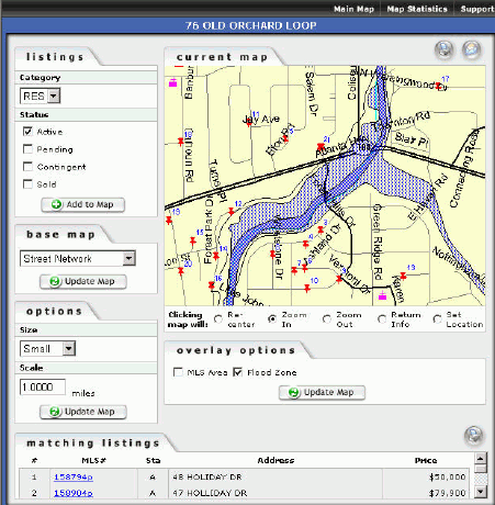
Figure 2: Property locations with FEMA Special Flood Hazard Area
map overlay of the area.
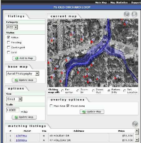
Figure 3: As Figure 2 with air photo.
One such quality control feature of LIST-IT corrects a typical problem
found with geocoding a home addresses: accuracy.What happens when the
location is wrong? When the realtor types in the address of a new listing
and the geocoding process incorrectly places the location along a street,
the realtor gets a screen that asks them 'is that where the property is
located' and then they have the option of interactively placing it in a
more correct location.This action is recorded by LIST-IT and becomes a
persistent change in the database."There is a 'georesult' score that tells
LIST-IT how accurate the newly-placed point is from the line segment interpolation
geocoding program," Fowler indicated.So, what happens if the home is placed
back on the market in the future? "We re-geocode the whole database every
quarter with the updates that come out from the mapping company, but we
don't ever override the realtor-indicated matches," said Fowler.The next
realtor who becomes the selling agent though can "clone" the listing information
and continue to make changes to the location, with each change being noted
accordingly.Another interactive feature of the system is the ability to
draw an irregular polygon (See Figure 4) to use as search criteria for
homes within an area where zip code, school district or MLS area would
not serve the needs of the realtor.
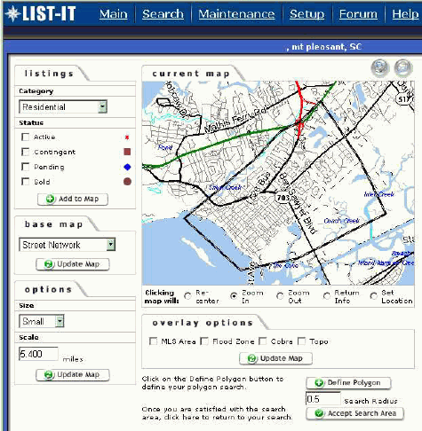
Figure 4: Polygon-define feature for spatial queries.
Early in the development of LIST-IT, Solid Earth developed a modular design for their solution.The real estate board that purchases LIST-IT hosts most of the MLS application in conjunction with the inventory of properties.However, the mapping modules of LIST-IT are hosted on servers maintained by Solid Earth.
LIST-IT employs MapInfo's MapXtreme® mapping engine with MapMarker geocoding and supported with an Oracle database.Solid Earth is looking to add a routing application using the Routing J Server product, which they will offer as a premium service to their customers.Solid Earth uniquely couples their MLS application with their mapping applications.However, they have licensed the mapping component that they call Mapmachine.com to one real estate board that has decided to create their own MLS but wanted a mapping interface as well.
Solid Earth recommends that each realtor take the time to sit with the client to preview properties."The realtors are always trying to get you to come see them.LIST-IT is something that may encourage the client to do that because the realtor will say 'if you come to my office you can draw a line around where you want to live and I can let you know what's there.' The realtor can take the client to see these house, or even better, can set up a nightly email notification for anything that is near the area of interest or anything that changes in the market area," said Fowler.
Solid Earth has about 6% of the market share for MLS systems nationwide and prefers to grow at a rate that maximizes their ability to supply superior service to their clients.Currently, their largest MLS is the Greater South Bay Regional Board in Torrance, California that includes the cities of Redondo Beach, Manhattan Beach, Palos Verdes, Hermosa Beach, Torrance, and Inglewood."Probably, the most interesting thing about South Bay is that they have 4500 users, but on average have only about 1600 active properties for sale at any one time.And that is backwards.Nationally, there are about 3 listings per realtor.That's upside down in the LA area.The reason for this is that average time on the market for a home, nationally, is about 100 days; in LA it is about one-third that time.In other words, they turn three times the inventory in the same time that a single home will sell," Fowler commented."So, if you are a realtor in that market, its all about speed.If you're not the first person to get to the showing, you lost it.This market has been a great proving ground for our system because when we throw out a new application to that system, we know very quickly whether it's going to work and what needs to be done to make it functional."
LIST-IT has achieved a level of notoriety because of the mapping interface and data among other industry solutions.In a recent national survey conducted by Clareity Consulting in their 2nd Annual Internet MLS Customer Satisfaction study (released February 2003), Solid Earth was recognized for "gaining a loyal following by providing excellent service" and ranked 3rd overall in vendor-supplied systems.The ability to provide spatial information enhances a prospective homebuyer's ability to quickly narrow choices through spatial criteria.It provides the agent a level of technical sophistication that allows them to deliver a service that others can not, if they choose to use it.And in the highly competitive field of real estate, every advantage helps.