The one lesson we have learned from the war
in Iraq is that spatial data is both ubiquitous and invisible.A conundrum?
Not quite.But you've seen the flood of spatial information used throughout
the media coverage: Earthviewer technology integrated with DigitalGlobe
imagery has combined to give media talking heads the "bird's-eye view of
downtown Baghdad.TV and newspaper reports are laced with battle plan maps.
Oh, and then, the most famous map of all...Geraldo Rivera's "hand-drawn"
map of the existing coalition force's position, clearly in violation of
embedded media guidelines, and once again showing us why FOX Network has
the reputation of a sleazy tabloid.
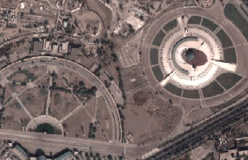
Baghdad - Before the Bombs - March 7, 2003 - Downtown (right) & Airport (left)
(Courtesy of ImageLinks & DigitalGlobe)
How invisible? Well, just don't peek too close inside the nose cone of a cruise missile for the GPS receiver, or the general's tent as he surveys the real-time battle taking shape on his laptop GIS.It's there...you'll just never hear about...yet.Oh, indeed, GIS in ruggedized laptops and workstations are there in full force.For battle management, weather, troop deployment, flight ops, and much more.
Yes, ubiquitous and yet some, at least by reading some of the Direction's Magazine Discussion Lists, you might think, would have you bemoaning the lack of the recognition afforded to "GIS" technology, or at least the mere mention of the acronym.OK, let's get over it.You'll never hear "GIS" mentioned by Peter Jennings or Wolf Blitzer, or Christiane Amanpour.That's fine...so long as its used.We see the maps, we see the satellite data.Unfortunately our "geocentric" view of the world would have us wanting some booming "Darth-Vaderish" voice proclaiming "THIS IS GIS."
I think we would all love some recognition of our profession, but let's not get hung up on it.We are doing our jobs, advancing the use and utility of a great tool.And whether on the front page or the web page no one sees, spatial information and technology has shown how invaluable a resource it has become, especially in wartime.And in this war, GIS is "embedded" with the troops.
From Our Homepage
Saying Farewell to an Amazing Journey
Communicating with Maps
Is There a GIS Career Ladder?
What does it mean to be geospatially smart? Series
Ways Real Estate and Property Developers Utilize Melissa GeoData for Data-Driven Decisions
Unlocking Value From Daily Satellite Imagery and Insights
Maximizing the Value of Your Address Data with Geo Addressing
How Indoor Mapping Enhances the Security of Smart Buildings
Look Ahead: AI, Location Intelligence and Efficiency
Collaboration Takes on Sea Level Rise & Dynamic Technology Environments
Brownies for Brownfields
Has Everything Been Mapped Already?
How Is Data Literacy Changing in an Artificial Intelligence Landscape
Portfolios for GIS Professionals: More Than Just Maps
How to Create a Distance Matrix in QGIS - A Step-by-Step Guide
7 Ideas for Bringing GIS into the K-12 Classroom
The Geography of Movement