
Last week, IBM announced the release of DB2 Universal Database (UDB) that includes capabilities for autonomic computing, an enhancement that IBM says will, "allow organizations to complete complex jobs up to seven times faster than before while also reducing the time spent on administrative tasks by up to 65 percent." These autonomic capabilities are intended to reduce the labor-intensive and repetitive jobs normally assigned to database administrators.
DB2 Spatial Extender
For the geospatial community, the DB2 UDB release includes DB2 Spatial
Extender at no additional charge to users.DB2 Spatial extender includes
the some of the following capabilities:
- Conforms to the ISO SQL/MM Spatial Standard and the OpenGIS Consortium's (OGC's) Simple Feature Specification for SQL.
- Supports visualization tools, such as ESRI's ArcView® GIS, ArcInfo™, ArcView BusinessAnalyst, and ArcIMS.
- Support for additional operating systems.
- Indexing guidance tool that provides help with performance and tuning considerations.
- Improved import and export capabilities for shape files.These capabilities allow more precision and control over where and how spatial data is stored
- Improved set of administrative stored procedures.
- Enhancements to the Spatial Extender functions within the Control Center.
- Dynamic query support for units of measure, allowing user to specify the unit that is to be used to measure lengths, distances, and areas.
- Capability for users to define their own specialized spatial types, methods, and functions to further customize Spatial Extender to their business needs.
- New command-line processor that mirrors the Spatial Extender functions provided in the Control Center and also provides support for migration
Also available now is DB2 Geodetic Extender, an optional module that treats data in latitude/longitude coordinate system.To ensure optimal performance, IBM employs a Voronoi indexing scheme, a modified grid-based system for rapid data querying.This module requires DB2 UDB, Universal Developer Edition 8.2 or later with DB2 Spatial Extender installed.
Spatial Integration Adapter for WebSphere Studio![]()
In addition to the two modules mentioned above which support geospatial
applications, IBM has introduced the Spatial Integration Adapter for WebSphere
Studio.WebSphere is a scalable platform for enterprise data integration
and e-business.WebSphere contains a number of business process management
modules for various industries and supports standard development frameworks
such as Java™ 2 Enterprise Edition (J2EE), as well as Windows Data Center
and Red Flag Linux.The Spatial Integration Adapter is a visual programming
development tool for deploying geospatial web services.It is a platform
that allows the developer to create Enterprise Java Beans (EJB) and Java™
servlets (See Figures 1 & 2).
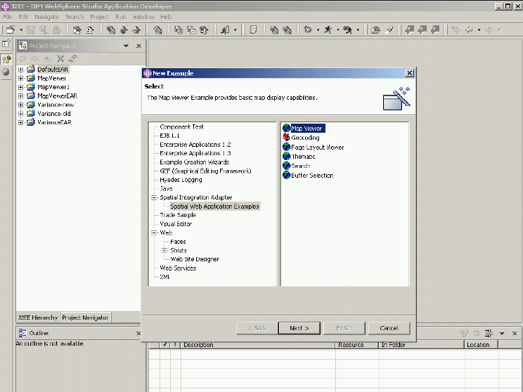
Figure 1 (Click for larger Image).Courtesy of IBM

Figure 2 (Click for Larger Image).Courtesy of IBM
According to David Beddoe, manager with the DB2 Spatial group, "This is a full Java development environment and in our implementation, provides specialized "roles" for how developers contribute with expertise in creating solutions (analytics, web content, graphics, business logic, for example) and provides the cross platform environment for using ESRI ArcGIS Server that is not afforded in .NET single platform environment.We take full advantage of and extend the capabilities of the ESRI Java ADF that ships with ESRI ArcGIS Server."
Support for Location-based Services
IBM is also more fully supporting location based services (LBS) with
a middleware solution called Location Aware Services (LAS) supported in
WebSphere Everyplace Access (WEA), which includes all the OpenLS location-aware
functions enabled (See Figure 3).
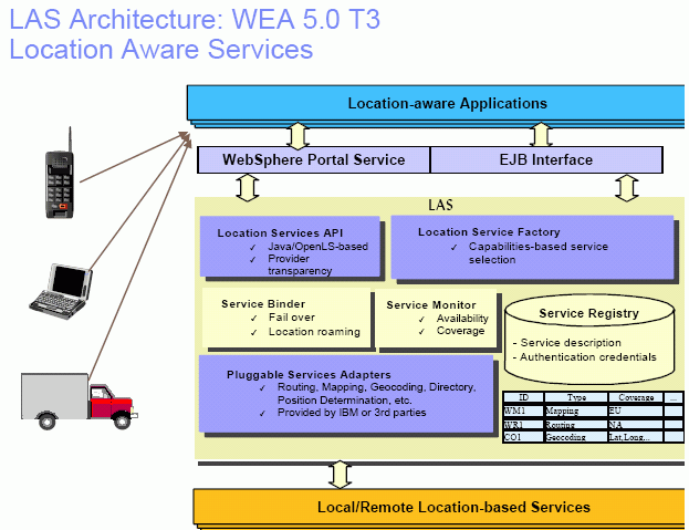
Figure 3 (Click for larger Image).Courtesy of IBM
LAS includes three sub-components which can be installed to meet the business objectives of the client including:
- Portlets ( WebSphere Portal)
- Location Aware Services Application Servers ( LasAppServer)
- Database
- PocketPC with Pocket Internet Explorer Browser
- Sharp Zaurus 5600/6000
- Sony/Ericsson P900 with Opera
- Palm Tungsten C with Web Browser
- ...and other.
- Webraska Personal Navigator
- MapInfo miAware 2.0
- Go2Map
- LIF
DB2 version 8.2 will be available September 17, 2004, with pricing
beginning at $25,000 for DB2 Enterprise edition.For more information on
DB2 Universal Database, visit www.ibm.com/software/data/db2/udb/v82.