No Jokes
Perhaps you remember the old joke, "Everyone complains about the weather, but no one does anything about it!" An updated version for those using online and organizational mapping applications might be, "Everyone complains about how old imagery is, but no one does anything about it!" One reason for this lack of action has been the challenge of scraping together the funds to procure imagery (satellite or aerial) since most providers require a minimum area or price to capture or process an order. You likely know where I'm going from here and you are right: A company called TerraPixel is stepping up to address this challenge with a service called ImagePatch.
The ImagePatch service provides high resolution (3, 6, 12 inch) orthographic or oblique images for areas as small as 20 acres in 30 days at reasonable (some might say inexpensive) prices. Pricing is based on a variety of factors (resolution, area covered and location in proximity to flight launch base, rectification, format), but TerraPixel Managing Director Rony Ledany suggests that it's typically thousands of dollars, versus a minimum of tens of thousands for larger areas. What that means, he explains, is that CAD and GIS users who currently depend on services like GlobeXplorer's ImageConnect or tap into Google Maps/Earth and Microsoft Virtual Earth and use "whatever's available" can now get days-old imagery instead of archived images from months or years ago. There are a variety of samples for different uses in the samples gallery.
How ImagePatch Works
TerraPixel maintains its own aerial equipment in the Northeast and works with a network of partners across the U.S. to cover other geographies. On the satellite side, a newly announced partnership with GeoEye makes worldwide 1-meter data available now from IKONOS, and ensures 50-cm data from the GeoEye-1 satellite (expected to launch in the third quarter of 2008) will be available via ImagePatch in the coming months. Another partnership with MapMart allows customers to match new photos with existing archived data.
The 30-day turnaround is unique in the business, so far as I know. Most aerial projects of any size (town or county, for example) require months or a full year for delivery. The small areas mean processing can be done quickly in whatever form the client prefers: RAW or JPG unrectified, or with "GIS grade" (not mapping grade) rectification in KMZ format for Google Earth or YUM format for Microsoft Virtual Earth users. GeoTiff, for use with GIS and GeoPDF are available for additional fees.
The vision is that local governments that may not be able to fly the entire municipality for another year (or more) will be able to afford an ImagePatch for the specific area needed in high resolution for an upcoming project.
Ordering Patches
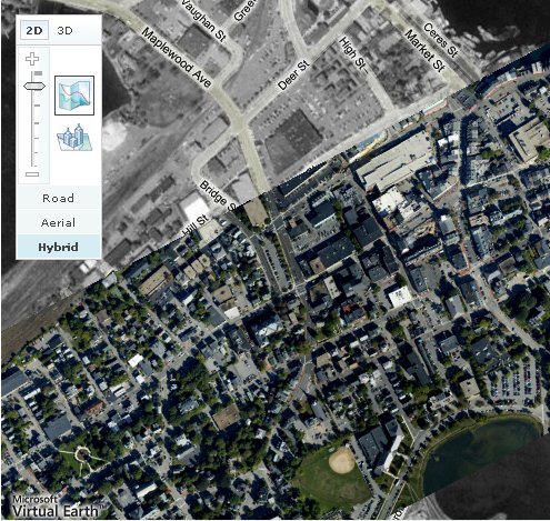
ImagePatch uses Microsoft Virtual Earth as its interface for the image buyer to determine the area of interest. The process is a familiar series of steps:
Evaluating the Service
There are a few things that make this service interesting and in some ways unique. It:
Perhaps you remember the old joke, "Everyone complains about the weather, but no one does anything about it!" An updated version for those using online and organizational mapping applications might be, "Everyone complains about how old imagery is, but no one does anything about it!" One reason for this lack of action has been the challenge of scraping together the funds to procure imagery (satellite or aerial) since most providers require a minimum area or price to capture or process an order. You likely know where I'm going from here and you are right: A company called TerraPixel is stepping up to address this challenge with a service called ImagePatch.
 |
The ImagePatch service provides high resolution (3, 6, 12 inch) orthographic or oblique images for areas as small as 20 acres in 30 days at reasonable (some might say inexpensive) prices. Pricing is based on a variety of factors (resolution, area covered and location in proximity to flight launch base, rectification, format), but TerraPixel Managing Director Rony Ledany suggests that it's typically thousands of dollars, versus a minimum of tens of thousands for larger areas. What that means, he explains, is that CAD and GIS users who currently depend on services like GlobeXplorer's ImageConnect or tap into Google Maps/Earth and Microsoft Virtual Earth and use "whatever's available" can now get days-old imagery instead of archived images from months or years ago. There are a variety of samples for different uses in the samples gallery.
How ImagePatch Works
TerraPixel maintains its own aerial equipment in the Northeast and works with a network of partners across the U.S. to cover other geographies. On the satellite side, a newly announced partnership with GeoEye makes worldwide 1-meter data available now from IKONOS, and ensures 50-cm data from the GeoEye-1 satellite (expected to launch in the third quarter of 2008) will be available via ImagePatch in the coming months. Another partnership with MapMart allows customers to match new photos with existing archived data.
The 30-day turnaround is unique in the business, so far as I know. Most aerial projects of any size (town or county, for example) require months or a full year for delivery. The small areas mean processing can be done quickly in whatever form the client prefers: RAW or JPG unrectified, or with "GIS grade" (not mapping grade) rectification in KMZ format for Google Earth or YUM format for Microsoft Virtual Earth users. GeoTiff, for use with GIS and GeoPDF are available for additional fees.
The vision is that local governments that may not be able to fly the entire municipality for another year (or more) will be able to afford an ImagePatch for the specific area needed in high resolution for an upcoming project.
Ordering Patches
ImagePatch uses Microsoft Virtual Earth as its interface for the image buyer to determine the area of interest. The process is a familiar series of steps:
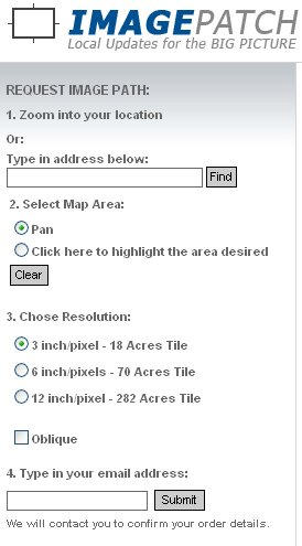 |
- Find the location via address or zooming/panning
- Define the boundary of interest by drawing a rectangle
- Select resolution (for now 3, 6 or 12 inch, but more on the way) and either ortho or oblique
- Enter an e-mail address for confirmation
Evaluating the Service
There are a few things that make this service interesting and in some ways unique. It:
- removes the time, cost and complexity of searching for vendors to fly small areas
- makes high resolution, "new" images accessible to even the smallest of companies/organizations
- requires almost no special expertise on the part of the person ordering
- solves in short order the "why is the imagery so old" problem
- relies on partners to find customers (MapMart, for example) and procure the imagery (GeoEye and a number of small aerial operators).
From Our Homepage
Saying Farewell to an Amazing Journey
Communicating with Maps
Is There a GIS Career Ladder?
What does it mean to be geospatially smart? Series
Ways Real Estate and Property Developers Utilize Melissa GeoData for Data-Driven Decisions
Unlocking Value From Daily Satellite Imagery and Insights
Maximizing the Value of Your Address Data with Geo Addressing
How Indoor Mapping Enhances the Security of Smart Buildings
Look Ahead: AI, Location Intelligence and Efficiency
Collaboration Takes on Sea Level Rise & Dynamic Technology Environments
Brownies for Brownfields
Has Everything Been Mapped Already?
How Is Data Literacy Changing in an Artificial Intelligence Landscape
Portfolios for GIS Professionals: More Than Just Maps
How to Create a Distance Matrix in QGIS - A Step-by-Step Guide
7 Ideas for Bringing GIS into the K-12 Classroom
The Geography of Movement