Although the Santa Ana winds did not blow the fires as
far east as Redlands this time, ESRI still found itself on the front
lines in support of the effort to control the southern California fires
that swept through Orange, San Bernardino, Riverside and San Diego
counties last week. This was not the first time ESRI has supported fire
fighting in this region. The company already had resources in place, as
well as established personal relationships which had developed during
and after the fires of 2003.
Russ Johnson, the public safety industry manager for ESRI and a former 30-year member of the San Bernardino fire force, described the assistance ESRI provided coordinating support for incident managers. "The SoCal fires happened pretty quickly and multiplied much more rapidly than in the past," said Johnson. "As a result, more resources flowed into the areas so quickly that on the ground, (firefighters) were directed to protect structures first. So for the first few days, in terms of (firefighters) on the ground, no one was very effective in giving people data. By the third day, when there was more command and control structure built around the incidents, that’s when we were effective in providing data, data storage and building maps that provided the answers to strategic operations," he said.
Initially, fire fighters were postured defensively. They were most intent on trying to protect assets in the path of the flames. Severe wind turbulence caused by the fires created a flight safety hazard for pilots and thus hindered their ability to disperse flame retardant chemicals. For the first few days, the winds were very strong at the coast but not at higher elevations. As high pressure developed over the region, winds settled lower and lower, and both the mountain ranges and coastal areas were exposed to extreme fire danger. Johnson explained that this wind condition was both unique and unusually severe. Add in drought conditions, an increase in housing developments, and an insect infestation that created more dead timber and a "perfect storm" was underway.
Fire Modeling Sent out of Kilter
Geospatial data helps to predict the spread of fires in many ways. Vegetation extent, topography and the ability to indicate where the wind will align with that topography are all key inputs. Models developed with these criteria give decision makers the data necessary to reduce losses. But the Santa Ana winds blew differently this time. Predicting where the fires would spread next was complicated by changing wind patterns and the unusually dry conditions.
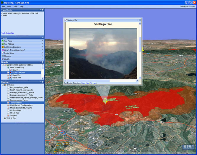
At the incident level, where much of the action occurs very rapidly, GIS specialists with the SoCal Operations Center were using GIS data to tell the incident commanders where to build bulldozer lines and other firebreaks. At the strategic level, where more long-range planning can occur, they provided the parcel data that was overlaid with the perimeter of the fire. This allowed incident managers to notify citizens about the fire’s status, help route emergency vehicles to hospitals, determine shelter locations and deploy necessary equipment. In addition, from a western states perspective, the command and control managers could more effectively select areas from which they could draw outside fire fighting assets.
Geospatial data are continuing to support the efforts to contain the fires and help predict where they might be headed. The technology has become an indispensable element in helping command and control managers to alert the population and minimize property losses.
Russ Johnson, the public safety industry manager for ESRI and a former 30-year member of the San Bernardino fire force, described the assistance ESRI provided coordinating support for incident managers. "The SoCal fires happened pretty quickly and multiplied much more rapidly than in the past," said Johnson. "As a result, more resources flowed into the areas so quickly that on the ground, (firefighters) were directed to protect structures first. So for the first few days, in terms of (firefighters) on the ground, no one was very effective in giving people data. By the third day, when there was more command and control structure built around the incidents, that’s when we were effective in providing data, data storage and building maps that provided the answers to strategic operations," he said.
Initially, fire fighters were postured defensively. They were most intent on trying to protect assets in the path of the flames. Severe wind turbulence caused by the fires created a flight safety hazard for pilots and thus hindered their ability to disperse flame retardant chemicals. For the first few days, the winds were very strong at the coast but not at higher elevations. As high pressure developed over the region, winds settled lower and lower, and both the mountain ranges and coastal areas were exposed to extreme fire danger. Johnson explained that this wind condition was both unique and unusually severe. Add in drought conditions, an increase in housing developments, and an insect infestation that created more dead timber and a "perfect storm" was underway.
Fire Modeling Sent out of Kilter
Geospatial data helps to predict the spread of fires in many ways. Vegetation extent, topography and the ability to indicate where the wind will align with that topography are all key inputs. Models developed with these criteria give decision makers the data necessary to reduce losses. But the Santa Ana winds blew differently this time. Predicting where the fires would spread next was complicated by changing wind patterns and the unusually dry conditions.
At the incident level, where much of the action occurs very rapidly, GIS specialists with the SoCal Operations Center were using GIS data to tell the incident commanders where to build bulldozer lines and other firebreaks. At the strategic level, where more long-range planning can occur, they provided the parcel data that was overlaid with the perimeter of the fire. This allowed incident managers to notify citizens about the fire’s status, help route emergency vehicles to hospitals, determine shelter locations and deploy necessary equipment. In addition, from a western states perspective, the command and control managers could more effectively select areas from which they could draw outside fire fighting assets.
Geospatial data are continuing to support the efforts to contain the fires and help predict where they might be headed. The technology has become an indispensable element in helping command and control managers to alert the population and minimize property losses.
 |
From Our Homepage
Saying Farewell to an Amazing Journey
Communicating with Maps
Is There a GIS Career Ladder?
What does it mean to be geospatially smart? Series
Ways Real Estate and Property Developers Utilize Melissa GeoData for Data-Driven Decisions
Unlocking Value From Daily Satellite Imagery and Insights
Maximizing the Value of Your Address Data with Geo Addressing
How Indoor Mapping Enhances the Security of Smart Buildings
Look Ahead: AI, Location Intelligence and Efficiency
Collaboration Takes on Sea Level Rise & Dynamic Technology Environments
Brownies for Brownfields
Has Everything Been Mapped Already?
How Is Data Literacy Changing in an Artificial Intelligence Landscape
Portfolios for GIS Professionals: More Than Just Maps
How to Create a Distance Matrix in QGIS - A Step-by-Step Guide
7 Ideas for Bringing GIS into the K-12 Classroom
The Geography of Movement