AMANDA is an automated business licensing and permitting system provided by CSDC Systems Inc. The city of Guelph, Ontario currently uses it to manage most land-related activities, including building permits, planning approvals, building inspections, enforcement activities, licensing, etc. There is a great demand to integrate GIS with AMANDA in many municipalities because instant access to mapping information improves decision making and efficiency during the process of licensing and permitting. In these areas, nothing can beat a visual representation.
The city of Guelph had requested the integration of GIS with AMANDA for more than 10 years. But integration was not easy because of the differing GIS interfaces, data structures and communication procedures, even though CSDC had introduced the AMANDA-GIS Adapter as a communication gateway between the GIS system and the AMANDA system.
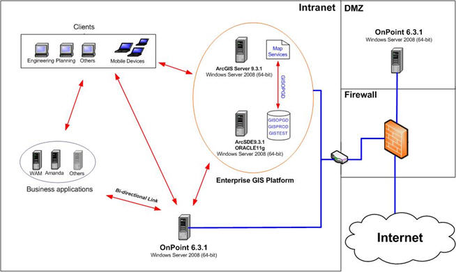
In early 2010, the system architecture for the city’s enterprise GIS model was redesigned (Figure 1). The most current versions of ArcGIS Server and ArcSDE (version 9.3.1) from Esri were successfully implemented as the platform for data maintenance and data sharing across the entire city. The city’s internal and external Web-based GIS applications (Rolta’s OnPoint 6.3.1) were redeveloped as well, to provide citywide users with robust and user-friendly GIS functionalities. [Ed. note: The author wrote an article about the implementation last year.]
 |
With the enhancements of the technologies in the enterprise GIS model, it was now time to integrate GIS with AMANDA to take advantage of new functionality and features provided by the GIS visualization tools.
Piloting the Integration of GIS with AMANDA
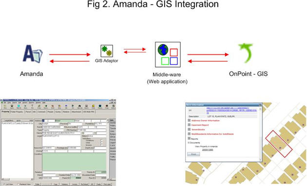
We started piloting the project of integrating GIS with AMANDA in November 2010. First the AMANDA GIS Adapter was installed in AMANDA to establish a gateway for communication between the AMANDA and the GIS. However, there is no existing solution available to pass the parameters from AMANDA to OnPoint (the city’s internal Web-based GIS application). Therefore, I developed a Web application as middleware to receive parameters from AMANDA via the GIS adapter, to process the parameters and then pass them on to OnPoint, or vice versa (Figure 2).
 |
In order to make sure that there was a valid link between AMANDA and the city’s GIS, city data technicians validated the AMANDA and GIS datasets so that up to 80% of the properties in AMANDA had a valid link in OnPoint. The next step was to improve the percentage to 95%.
In general, with this pilot solution, the AMANDA users can easily access spatial information in the city’s internal Web-based GIS application, such as layers of property, addresses, zoning, aerial photos and much more. The GIS capabilities will provide AMANDA users with appropriate and accurate spatial information for making decisions and will help improve the efficiency and speed of the licensing and permitting processes.