Speaking on behalf of Intergraph, Mark Doherty, a Senior Marketing Director, had this to say about the joint endeavor:
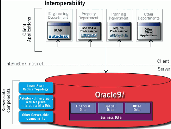
"Specifically what we've addressed is a few nagging issue in interoperability, specifically point features and cartographic text and annotation.The way it has worked out with Oracle Spatial is that they did not have an organized way to deal with oriented point.which is important to a lot of our customers.And while they can certainly store a point geometry or clear ASCII text, Oracle Spatial has not yet defined a way to store cartographic text, where you store things like rotation, orientation, font size, font type, and that sort of thing.So, different vendors went off and tackled that different ways.And what we've done with this particular initiative is that we've come up with a practical way in the initial phase to deal with different ways that different vendors store point features and cartographic text.So, what we are delivering, through our interoperability kits are a set of store procedures that reference an interoperable data model for points and cartographic text.And, if users install the set of stored procedures via a trigger in an Oracle database, then points and cartographic text can become truly interoperable between MapInfo, Intergraph GeoMedia and Autodesk product offerings."The initiative was driven by customers.One in particular, the City of Winnipeg, Manitoba, had a mixed environment of Intergraph, MapInfo, and Autodesk and wanted way to more easily share data among the software platforms. So, initially, the solution was developed for a specific customer but over time, it was realized that other customer would have this same need.For example, the Intergraph press release identifies the Staffordshire County Council in the United Kingdom."Achieving interoperability for e-government Staffordshire County Council in the United Kingdom uses a range of off-the-shelf applications including Intergraph GeoMedia Professional, Autodesk MapGuide and MapInfo Professional to view, query and update data within Oracle. Laser-Scan's Radius Topology provides automatic server-side topology management. A key step to achieving United Kingdom e-government targets ahead of the 2005 deadline, the system streamlines Staffordshire's business processes and makes its spatial data ready for sharing with other government organizations."
This entire initiative was very much driven because both customers had a critical need to share data, a principal goal of the Open GIS Consortium (OGC).So, is the intent of this initiative to be brought under the OGC umbrella? "Absolutely, that is the goal," says MapInfo's Tom Meyers.Intergraph's Doherty elaborates, "That get's into what we are calling the second phase of this initiative.And that is taking the common interoperable formats as one input to the process and taking that forward into the OGC to come up with standard ways inside their process to deal with things like oriented points and cartographic text which have not been dealt with up to this point.
The kits that the vendors deliver is server side software.They are stored procedures inside of Oracle and each vendor will be releasing the kits soon.[Intergraph has already released their kit.Intergraph's beta version of the kit can be found here.]
So how does it work? If someone creates a text string through a map view in Intergraph's GeoMedia to annotate a feature, for example, the Oracle database is updated with that data.But, in addition, a stored procedure in Oracle "fires" a trigger that writes to a "text data model" and subsequently notifies another trigger via the interoperability kits from the other vendors to write the changes to the appropriate format.As such, when another client-side software, like MapInfo Professional, attempts to view the changes to the database, the interoperability kits allows this new data element to be interpreted correctly and viewed properly.All of this is done transparently to the user.
Doherty warns however, "One of the things we recognize is that we all don't have identical capabilities in terms of the ways we deal with points or we deal with text.So, those limitations still apply inside the client's software.But what we have achieved is for the ability of each individual's client software to access the data and display with the capabilities that that software has."
Even though there will be some areas of "non-interoperability" because of differing functionality that is supported by each vendor, this initiative appears to be one of the most beneficial efforts to come from OGC members. At this time, the kits have not been through a process by which the OGC can officially endorse the interoperability kits.However, it should be a sign that the vendors are not willing to wait for OGC sponsorship when customer needs have to be met.
Visualizing the process, Intergraph supplied the following diagram (click for larger size):
More information about what each vendor is doing in can be found in the whitepapers that each company has supplied:
Autodesk Whitepaper: http://www.autodesk.com/isd
Intergraph Whitepaper: http://www.intergraph.com/gis/interop/oracle.asp
MapInfo: http://www.mapinfo.com/oracleinteroperability
Laser-Scan: http://www.radius.laser-scan.com/about/interoperability.htm
