| 1. Has wireless locations-based technology been oversold to the public? Is there too much hype surrounding this technology? |
It often looks like too much hype when some innovative technology is being promoted actively to
 the market.However, location-based technology has really great potential, because of its unique ability to answer natural customer questions: "I am getting out of gas, so tell me how to get to the closest gas station?", or "I'd like to have a dinner and prefer Chinese food, what place can I go and how do I get there?", and this list can go on and on, since there is no limit for needs of the people.So, this technology is intended to supply people with information, which helps to make right decisions and save time and money.And the hype surrounding this technology just shows strong desire of companies to gain market share in this fast developing industry.
| 2. What types of LBS applications are truly useful? |
There is no doubt that more and more different applications employing location-based technology will be emerging in this area, but it seems like street level navigation, retail alerts and, of course, POI proximity search applications will become the most widespread and popular.
| 3. Where do you believe that new enhancements should be made to desktop GIS software? |
Well, first of all, what really looks perspective is separating data storage and complex data processing algorithms from business logic of specific desktop applications.Desktop GIS will benefit from global geographic services providing both data and generic data processing algorithms, eventually transforming into software implementing only application logic on top of existing global spatial databases and data processing services.For example, sales managers will continue using desktop GIS to perform specific tasks like determining sales areas, but all underlying data will be taken from some globally available data service and rendered in a particular way to the user.
| 4. What are the obstacles to improving the functionality of web-based GIS Solutions? |
Primary factor of web-based GIS solutions evolution is underlying data quality.Data quality affects greatly overall quality of GIS solutions, hence making it a major risk for improving functionality.So it is necessary that data vendors to keep up with GIS solutions progress by improving data processing algorithms and increasing data quality.
| 5. Will spatial databases from Oracle, Microsoft, and IBM further the deployment of software throughout major corporations? |
They certainly will, but it is required that those databases are designed considering GIS specifics, so that such spatial databases could be seamlessly integrated with GIS software.
| 6. How much is GIS used in Russian public agencies and ministries? |
GIS is widely used in regional and municipal cadastre departments, railroad, and automotive transport ministries.Also, municipalities make use of GIS for land and water resources management.
| 7. In which schools in Russia is GIS being taught? |
Probably the most recognized school that has GIS being taught is Institute of Geography, Russian Academy of Sciences.However, there are many others, which do not have GIS as a major profile, but still having specialized courses in GIS like the one we have in our city - Taganrog State University of Radio Engineering.
| 8. Are many companies using GIS technology? Which applications are being used most? |
Yes, many companies are using GIS technology.For example, GIS is used for oil resources management, road networks analysis, land-utilization registration.The products of such companies as ESRI, Intergraph and others are being used along with proprietary GIS software created to suit specific needs.
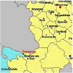
| 9. And just where is Taganrog, Russia? |