Ed. Note: Joe Francica spoke to Dr.Derrick Page, founder of Xenotran, recently. Xenotran is a design and engineering company that focuses on research, development and manufacturing of electronic and mechanical products for military and commercial applications.Joe's interview w/ Dr.Page focuses on XenoVision Mark III, a product that builds full color, accurate topographic models in under two minutes.

Dr. Page received both his B.Sc.and Ph.D.degrees in Electrical Engineering from the University of Birmingham, England.After receiving his doctorate, Dr. Page joined the Westinghouse Central Research Laboratories in Pittsburgh, where he was Manager of the Semiconductor Research, and later became Manager of Solid State Sciences at the Westinghouse Advanced Technology Division in Baltimore. In 1990, he was appointed Manager of Solid State Development Programs for Westinghouse, responsible for the development of communication systems. In 1995, Dr.Page founded Xenotran.Dr.Page has numerous publications in a variety of technical areas and holds 23 U.S.Patents.
Joe Francica (JF): Please explain how the XenoVision concept originated and what government initiatives you were responding to that led you to develop this solution.
Dr. Derrick Page (DP): The original concept had its beginnings with a Small Business Innovative Research (SBIR) request for proposal from the U S Army in June of 2001.Terrain models were time consuming to construct and presented a storage problem.This prompted the Army to issue this proposal request with the stated objective:
"The objective of the Command Post Dynamic Sand Table SBIR is to research and develop technology to create a physical terrain model with a surface that can be reconfigured based on digital terrain data.The height of the locations on the table surface will be proportional to the elevation of the terrain, with an exaggeration specified by the user."Xenotran Corporation wrote a proposal that would employ a matrix of pins controlled by a pneumatic addressing system.As is usually the case, Hollywood thought up the idea first with the pin terrain model featured in the movie X-Men.We had the task of reducing this special effect to actual hardware.
JF: Could you explain how the technology for the XenoVision has evolved from its original engineering design? What improvements do you think can be made in order to move it from a prototype to a production design?
DP: The original design was invented during the preparation of the proposal, and we actually applied for patents before our contract was awarded.A prototype was constructed during Phase I and we had it working after about five months.The design was in line with our proposal.We were then awarded a Phase II to build a bigger and better Dynamic Sand Table. This did not prove to be so easy.We experimented with various hydraulic schemes, but finally settled for an electric drive.We also improved the electronic controls and developed a web interface.After 18 months of effort we were able to unveil the sand table, now name the XenoVision Mark III, at the ESRI show last August in San Diego.We are close to using the present design for our first production; there will be some small changes to enable some of the parts to be more readily manufactured.
JF: Can you give me some idea of the cost for the system once it is in a production environment?
DP: The initial price will be about $98K.As with any product, the price is likely to be reduced as we move down the learning curve in the years ahead.
JF: What competitive advantages do you see with your technology versus those of other 3D modeling and visualization concepts and designs?
DP: There is something compelling about seeing a real model in front of you.One that you can walk around, point, touch and feel.And then there is simplicity.No need for holograms and special glasses or restrictions on where you can stand.People have been making sand tables of one kind or another for thousands of years to prepare battle plans.Now we are enabling them to have a high tech version; one in which a variety of images can be displayed.Anything that can be displayed on a computer monitor can be displayed on our XenoVision Mark III.
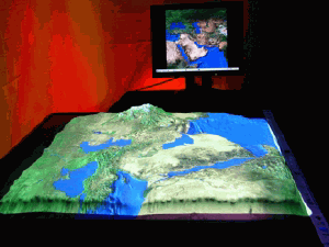
JF: Could you explain the process for creating the 3D representation on the XenoVision display table is driven by a digital elevation model?
DP: Producing a model on the XenoVision display table starts with georegistered data consisting of a digital elevation model (DEM) and a corresponding image.The DEM defines the physical surface while the image is projected on the surface.An area of interest, in a 4x3 aspect ratio, is extracted from the georegistered data.
The sand table software imports elevation data in GRIDASCII format and imagery in Joint Photographic Experts Group (JPEG) or Tagged Image File Format (TIFF) format.The JPEG and TIFF images are rectified, so the 2-dimensional images are positioned correctly on the 3-dimensional surface.
JF: Please explain about how the XenoVision display table is integrated with digital mapping software that is used to project ancillary graphics on the table's surface.
DP: In addition to displaying static images, the sand table supports rich, multimedia presentations.Content from any software application can be projected onto the surface of the table.This makes it ideal for developing engaging interactive and animated presentations using Macromedia Flash, Adobe Premiere, or Microsoft PowerPoint.
JF: What applications, now and in the future, do you see for the XenoVision?
DP: There are some obvious applications in the military area for planning and training.Other government agencies could use the XenoVision for disaster management such as forest fires and floods.In the civilian world the XenoVision could be used for real estate development and resort planning such as golf courses and ski runs.In the entertainment market it could be used in many areas such as the display golf greens and fairways from around the world right there in the clubhouse.Other areas completely different from mapping could include using the computer-controlled surface as a mold for rapid prototyping.
JF: Xenotran is a different company in that its business model is to develop technology and move them from incubation to production. Do you foresee developing other technology for the geospatial market sector and what might that be?
DP:
We do not
plan to move too far away from the Dynamic Sand
Table in the geospatial market.We have another sand table on the
drawing board
that will be able to morph one DEM into another.One model can be in
construction while the other is being displayed.This would reduce the
waiting
time for the next model to be formed.Another area would be to provide
a site
that XenoVision owners could visit and download processed, ready to
use, data
specifically for the sand table.Ultimately, this would be the 3D
version of
downloading a map from MapQuest.
JF: I'd like to thank you for your time, and your answers to our questions.