The Spatial Sciences Institute (SSI) Conference was held
in Melbourne, Sept 12th-16th.During the Asia-Pacific Spatial
Excellence Awards ceremony at the conference, the Victorian Spatial
Smart Tag (VSST)
won the award for Industry and Entrepreneurship as well as the spatial
industry's 'Gold Logie,' the J.K.Barrie Award for the Highest Level of
Achievement in Spatial Information.I want to take a look at the
concept of the "silver bullet" in geospatial technologies and this
technology in particular.
The Silver Bullet
Our industry is searching for relevance at a time of great technological change.New products from existing companies come with a fanfare of how they are the next big thing, how they use the latest and best technology (anyone for .NET?), how much better off you will be if you upgrade to the latest version...And so it goes.
Yet, it amuses me how such a technology-aware industry as ours seems to miss some vital signs of change - what truly makes for a "killer app."
So what is a "killer app"? I use the term in the following sense (from Wikipedia): "The term is especially used when the technology existed before but did not take off before the introduction of the killer application." We know that GIS existed before Google Maps and Google Earth, but it was only with these that our industry has become far more visible and mainstream.(Note: this article is not about Google technology - phew!)
Bruce Douglas's Corporate GIS Consultants conducts a yearly survey of GIS use in Australia. Interestingly, one of his findings is that there is a great deal of software "churn" in the industry.And it is increasing.He has publicly mused over why this might be: inadequate support, expensive on-costs (operational expenditure); superceded products, etc.But it is the customer that is increasingly saying that GIS is not meeting the needs (almost 46% of respondents) that he highlights.He asks, "are the vendors listening?" Douglas has also pointed out that a continual problem respondents report is the lack of strategic goal setting with respect to GIS expenditure and use.For example, 79% of recipients acknowledged that GIS funding was not suitably aligned with required outcomes and management expectations!
Could one reason for the churn be that our industry thinks of its technology as a "Silver Bullet"? One that will solve all problems? (World famine, whale extinction, population problems, deforestation?). Geography may bring us together, or be in 90% of our databases, but the technology is certainly not a silver bullet magically capable of solving geographic problems by virtue of being installed.Perhaps this is one reason for the technological "churn" Douglas muses about.I think it is predominantly the lack of connection to business outcomes (through strategy formulation and planning) that causes the churn.
In the arena of corporate business computing I am, like the next man, always looking for the next "killer app." In this space I think it is useful to extend the Wikipedia definition to also include those applications that will most affect the bottom line of most businesses (i.e., reduce cost, increase profitability) and at the same time increase the uptake of the technology but not necessarily increase its visibility.
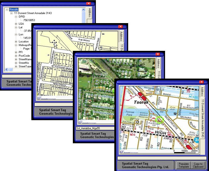
Enter Spatial Smart Tag
Spatial Smart Tag is based on existing Microsoft Smart Tag technology. This technology was introduced in Office XP and 2003's Excel, Word and PowerPoint components.Microsoft says this about Smart Tag technology:
Why did it come about?
Spatial Smart Tag was created by the Department of Sustainability and Environment (DSE) in conjunction with Microsoft and Geomatic Technologies Pty Ltd.DSE has staff and customers who fill in a lot of forms.Invariably, he most critical geospatial element on these forms is address information.Much time, effort and therefore money is expended filling in these forms and validating addresses.Other information is often derived from an address: for example, the nearest DSE office.The goal was to empower Government to use spatial information by:
In summary, the identified gains are:
Thanks DSE, Microsoft and Geomatics Technology for opening my eyes to the possibilities associated with true "embedding" of geospatial data and services.
The award was truly warranted.Congratulations.
The Silver Bullet
Our industry is searching for relevance at a time of great technological change.New products from existing companies come with a fanfare of how they are the next big thing, how they use the latest and best technology (anyone for .NET?), how much better off you will be if you upgrade to the latest version...And so it goes.
Yet, it amuses me how such a technology-aware industry as ours seems to miss some vital signs of change - what truly makes for a "killer app."
So what is a "killer app"? I use the term in the following sense (from Wikipedia): "The term is especially used when the technology existed before but did not take off before the introduction of the killer application." We know that GIS existed before Google Maps and Google Earth, but it was only with these that our industry has become far more visible and mainstream.(Note: this article is not about Google technology - phew!)
Bruce Douglas's Corporate GIS Consultants conducts a yearly survey of GIS use in Australia. Interestingly, one of his findings is that there is a great deal of software "churn" in the industry.And it is increasing.He has publicly mused over why this might be: inadequate support, expensive on-costs (operational expenditure); superceded products, etc.But it is the customer that is increasingly saying that GIS is not meeting the needs (almost 46% of respondents) that he highlights.He asks, "are the vendors listening?" Douglas has also pointed out that a continual problem respondents report is the lack of strategic goal setting with respect to GIS expenditure and use.For example, 79% of recipients acknowledged that GIS funding was not suitably aligned with required outcomes and management expectations!
Could one reason for the churn be that our industry thinks of its technology as a "Silver Bullet"? One that will solve all problems? (World famine, whale extinction, population problems, deforestation?). Geography may bring us together, or be in 90% of our databases, but the technology is certainly not a silver bullet magically capable of solving geographic problems by virtue of being installed.Perhaps this is one reason for the technological "churn" Douglas muses about.I think it is predominantly the lack of connection to business outcomes (through strategy formulation and planning) that causes the churn.
In the arena of corporate business computing I am, like the next man, always looking for the next "killer app." In this space I think it is useful to extend the Wikipedia definition to also include those applications that will most affect the bottom line of most businesses (i.e., reduce cost, increase profitability) and at the same time increase the uptake of the technology but not necessarily increase its visibility.
Enter Spatial Smart Tag
Spatial Smart Tag is based on existing Microsoft Smart Tag technology. This technology was introduced in Office XP and 2003's Excel, Word and PowerPoint components.Microsoft says this about Smart Tag technology:
"In Word, Excel, and Outlook, the Smart Tag Actions button recognizes your typing (such as a name or address in Word, or a stock ticker symbol in Excel) and lets you associate information and actions with that entry.A Smart Tag is indicated by a series of purple dots under the text.For example, if you type the name James Smith in Word or Outlook, you can use the Smart Tag Actions button to create a new Contact in Outlook, send an e-mail message, schedule a meeting, or find driving directions to the address. (Italics mine)"It is the last of these that is important.
Why did it come about?
Spatial Smart Tag was created by the Department of Sustainability and Environment (DSE) in conjunction with Microsoft and Geomatic Technologies Pty Ltd.DSE has staff and customers who fill in a lot of forms.Invariably, he most critical geospatial element on these forms is address information.Much time, effort and therefore money is expended filling in these forms and validating addresses.Other information is often derived from an address: for example, the nearest DSE office.The goal was to empower Government to use spatial information by:
- Improving access (one does not have to be a professional GIS person to use spatial)
- Providing basic functionality (e.g.geocoding)
- Leveraging existing infrastructure.Spatial Smart Tag puts existing Victorian and Australian spatial datasets, functions, and queries into the hands of non-expert users via Microsoft Word and Excel.Now that's integration!
- "Verify" Address verification
- "Find" a location
- "Get" a map.
 |
 |
In summary, the identified gains are:
- Simple productivity gains (no need to use additional sources, street directories, to validate address)
- Substantial process and transactional gains (ie removes manual form filling)
- Cheap compared to traditional per-client GIS packages
- Provides strategic (there's that term Bruce!) planning gains by driving business process improvements (value-add: from the address determine nearest departmental office).
Thanks DSE, Microsoft and Geomatics Technology for opening my eyes to the possibilities associated with true "embedding" of geospatial data and services.
The award was truly warranted.Congratulations.
From Our Homepage
Saying Farewell to an Amazing Journey
Communicating with Maps
Is There a GIS Career Ladder?
What does it mean to be geospatially smart? Series
Ways Real Estate and Property Developers Utilize Melissa GeoData for Data-Driven Decisions
Unlocking Value From Daily Satellite Imagery and Insights
Maximizing the Value of Your Address Data with Geo Addressing
How Indoor Mapping Enhances the Security of Smart Buildings
Look Ahead: AI, Location Intelligence and Efficiency
Collaboration Takes on Sea Level Rise & Dynamic Technology Environments
Brownies for Brownfields
Has Everything Been Mapped Already?
How Is Data Literacy Changing in an Artificial Intelligence Landscape
Portfolios for GIS Professionals: More Than Just Maps
How to Create a Distance Matrix in QGIS - A Step-by-Step Guide
7 Ideas for Bringing GIS into the K-12 Classroom
The Geography of Movement