LizardTech GeoExpress 6 – Product Overview
Distributor
LizardTech, A Celartem Company
1008 Western Ave. Suite 200
Seattle, WA 98104
Tel: 206-652-5211
Fax: 206-652-0880
www.lizardtech.com
Pricing:
GeoExpress Unlimited: Starts at $7,900.00
GeoExpress Standard: Starts at $2,900.00
GeoExpress Tools: Starts at $1,500.00
Free Trial Available
Introduction
This week, LizardTech released the latest version of GeoExpress, the company's image manipulation and compression software. According to LizardTech, most users today have been using GeoExpress as a compression tool only. However, they are also telling the company that they want to get the imagery into the LizardTech's proprietary MrSID format earlier in their workflow and then perform some basic image manipulation on the data.
Recently, Carlos Domingo, CEO, and Jon Skiffington, Product Manager, provided an overview of the product's new features and enhancements.
Executive Summary
GeoExpress 6 contains three primary productivity enhancements:
1. Color balancing and contract enhancement of tiled images has been incorporated to form a seamless mosaic.
2. Re-projection of images to any of 200 other projections and the ability to mosaic these images with disparate projections into a single projection has been added.
3. Users may selectively encode areas of an image by first using a vector overlay such as a shapefile or .TAB file so that only a portion of the image will be selected to undergo further image processing.
GeoExpress 6 also provides enhancements for data storage through Oracle Spatial 10gR2 by storing wavelet data natively. Speed of data retrieval and smaller file sizes are the primary advantages of storing imagery as wavelets. Appreciating these advantages, users seem to prefer managing the image in wavelet form without going back to pixels because of these advantages.
The GeoExpress 6 release contains a modified “floating” license agreement so that the product can be installed to an unlimited number of desktop computers within an organization. However, the available run-time executables are limited to only the number of licenses actually purchased. In addition, this version will include pre-defined image encoding profiles for JPEG 2000 to ensure compliance with certain government requirements.
GeoExpress 6: Product enhancement details
GeoExpress 6 uses histogram normalization to automatically color balance imagery (See Figure 1 [unbalanced] and 2 [balanced]). This is accomplished within a user's typical image compression workflow without the need for an external image processing software system. Users can correct tonal imbalances that occur at image edges by either independently selecting each image tile on which to perform contrast enhancements (band by band if necessary) or by electing to automatically color balance multiple image tiles at one time.

Figure 1 - Click for Larger Image
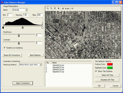
Figure 2 - Click for Larger Image
Users can also re-project an image to more than 2000 other projections pre-defined within GeoExpress 6. In addition, this release contains a function allowing users to take many images of differing projections and re-project the mosaicked image to one common projection.
Of interest to the intelligence community is the function to selectively encode areas of the image in order to degrade the resolution. For example, areas that may be considered sensitive to national security (e.g. The White House, Capital Hill) can be degraded to a lower spatial resolution. These areas can be preserved without losing the image's original resolution even after compression. However, an option to degrade the image's original resolution permanently is available as well. Vector graphic files (.SHP or .TAB) can be imported as an overlay to the raster imagery to inscribe the areas to be degraded.
The integration with Oracle Spatial provides for advanced image data management while reducing overall data storage. MrSID imagery can be stored natively in Oracle Spatial 10gR2. MrSID imagery can be directly retrieved from an Oracle database using any GeoRaster (Oracle's spatial datatype for raster data) - enabled application. Now, when user requirements call for a higher level of security or load balancing, these are already present in an Oracle database.
There will eventually be three ways to store or retrieve MrSID in Oracle Spatial:
1. Using the GeoExpress Software Development Kit (SDK)
2. Using Oracle's GeoRaster Application Programming Interface (API). The GeoRaster API supports wavelets in the database but will convert them to pixels on retrieval. (More on GeoRaster)
3. Employing the Open Geospatial Consortium's (OGC) Web Map Service (WMS) interface of LizardTech's image streaming server, Express Server.
New Licensing Policy
This version of GeoExpress 6 carries a flexible, floating licensing policy. Previously, the software licensing agreement for GeoExpress locked the executable files to a specific machine. Anytime a user wished to install a copy of GeoExpress on a different machine, LizardTech had to be contacted directly to issue a different license agreement. Now, network administrators can install software on as many machines as desired and purchase only the number of licenses as needed by the organization. The licenses are shared and access to working copies of the software is limited to the specified number purchased.
Other Company Developments
LizardTech's business objective is to increase the use of imagery. The company hopes to do this by speeding the workflow of image processing. The company has worked with Galdos Systems and the OGC to use GML to store imagery metadata.
From Our Homepage
Saying Farewell to an Amazing Journey
Communicating with Maps
Is There a GIS Career Ladder?
What does it mean to be geospatially smart? Series
Ways Real Estate and Property Developers Utilize Melissa GeoData for Data-Driven Decisions
Unlocking Value From Daily Satellite Imagery and Insights
Maximizing the Value of Your Address Data with Geo Addressing
How Indoor Mapping Enhances the Security of Smart Buildings
Look Ahead: AI, Location Intelligence and Efficiency
Collaboration Takes on Sea Level Rise & Dynamic Technology Environments
Brownies for Brownfields
Has Everything Been Mapped Already?
How Is Data Literacy Changing in an Artificial Intelligence Landscape
Portfolios for GIS Professionals: More Than Just Maps
How to Create a Distance Matrix in QGIS - A Step-by-Step Guide
7 Ideas for Bringing GIS into the K-12 Classroom
The Geography of Movement