This might include a search on a particular address, an area regarding planning permission or a proposed development.It may also be a search to find out the range of facilities or infrastructure that exist in the locale of an address.Spatial data can also provide important links between datasets so that "joined up" government becomes possible.
The London Borough of Enfield (LBE), a proactive and forward-looking Borough Council, is already making significant progress in addressing its e-government targets.The council has recognised that success lies in making data from each department accessible to all other departments, as well as to the wider community.In other words, creating a single, enterprise-wide database.This is not as simple as it sounds! However, LBE expects 100% clean and structured data in little more than five weeks, reducing their original estimate by almost 5 years.
Bringing data into line
Currently, each department in LBE sets its own standards and maintains
its own data.This can lead to difficulties when data needs to be used
across several departments.In addition, much of this data has been collected
over a number of years and by different software packages, leading to further
inconsistencies.In short, LBE discovered that extensive work was required
in cleaning the data before it could be useable across the organisation.
Until now, LBE has relied on human intervention to analyse its data and correct any errors (such as gaps or overlaps in boundaries).However, not only is this subjective, it is also extremely time-consuming.It was estimated that to clean the entire dataset manually, using existing tools would take 5 years! Even after this time, the correctness of the data would not be guaranteed, chiefly due to the lack of ability to maintain this accuracy over time, as the data changes.
Enterprise-wide interoperability.
Another consideration for LBE was the new OS MasterMap™ data; initial
trials showed discrepancies between the council's own dataset and Ordnance
Survey's digital product.In order to make the most of OS MasterMap™ it
is important that the datasets are compatible.It was clear that LBE needed
to identify a new solution: one that would electronically remove errors
and ultimately produce a definitively clean dataset, ready for use throughout
the organisation.
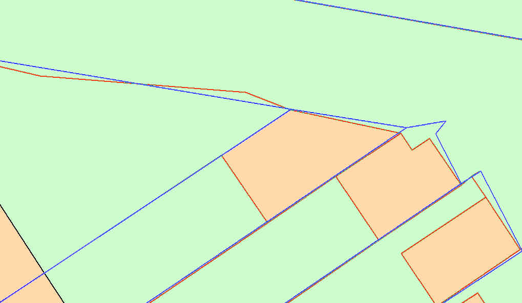
Figure 1.LBE's polygons (shown in blue) opposite
were supposed to line up with the OS MasterMap™
data (orange and red), but there were frequent differences.
(Data courtesy of Ordnance Survey GB © Crown Copyright)
Click for larger image
"In order to meet government electronic service delivery targets, Enfield, like all Councils, needs to pay close attention to the quality of its data," said Mick Wooden, Information Manager at LBE."This is especially true of spatial data, which accounts for 80% of all data.Spatial data collected over a long period by many different services and through different software is not 'fit for purpose' to meet future requirements.After research of the market, we found that Laser-Scan's Radius Topology product was most capable of ensuring data quality standards."
Dynamic Topology
Radius Topology is a dynamic topology management layer stored in Oracle9i,
creating a server-side topological solution for handling the structure
of spatial information.This technology also acts as a "gatekeeper", only
allowing clean, accurate data into the database.Inconsistent data is automatically
corrected, within the bounds of user-defined business rules.So, no matter
who adds new data or which software they use, the systems looks to ensure
that it is error-free and, above all, accessible across the organisation.
In any information system environment the database used to store, edit and query data must have the confidence of its users.The database is the key to solving the problems of information management.It must be secure, reliable, provide assurance of maintaining data integrity and provide acceptable performance when the user retrieves information from it.The Oracle server is an object-relational database management system that provides an integrated approach to information management.
Matching up to OS MasterMap™
Radius Topology is being used to clean up all the gaps, slivers, overshoots
and undershoots (of 20cm or less) that exist between LBE BLPUs (Basic Land
and Property Unit) and OS MasterMap.Any BLPU feature that differs from
OS MasterMap by 20cm or less will automatically be adjusted to match the
OS MasterMap data.If BLPU features are more than 20cm apart their geometric
shape will not be adjusted.In fact, a difference of more than 20 cm is
often valid as not all BLPU features actually coincide with all OS MasterMap
features.
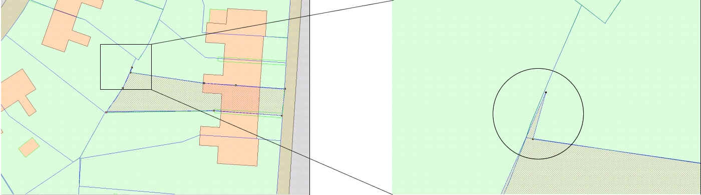
Figure 2.As well as not matching OS MasterMap,
the data also contained errors such as spikes.(Data courtesy of Ordnance
Survey GB © Crown Copyright)
Click above for larger image
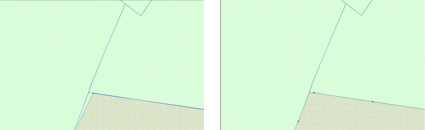
Figure 3. Deleting one vertex removed the spike,
Radius Topology then corrected the whole polygon.(Data courtesy of Ordnance
Survey GB © Crown Copyright)
Click above for larger image
Even though the geometric shape of the feature is not corrected for differences larger than 20cm, topological information is still calculated and stored.This means the features can be analysed 'topologically' to find out adjacency, connectivity and containment relationships.It is now very simple to identify exactly where anomalies occur, and to highlight them for further analysis.Another benefit of topological analysis of data is that it is significantly faster than standard spatial analysis because no heavy geometric computations are required.
Other types of analysis that were not previously possible, such as finding holes in the data, are now achievable using the topological queries.This allows LBE to track down inconsistencies that may otherwise have gone unnoticed. As well as being fit for use within a single database, the data will also be ready to be linked up with national datasets within NLIS (National Land Information Service), the NLPG (National Land and Property Gazetteer) and the NSG (National Street Gazetteer).By working with Radius Topology, LBE expects 100% clean and structured data in little more than five weeks, a significant improvement on the original five year estimate.
Click here for a demonstration showing how the London Borough of Enfield has used Radius Topology to improve their data quality and move towards meeting their 2005 e-Government targets.
Authors:
Mick Wooden, London Borough of Enfield
Seb Lessware, Laser-Scan