I'm trying to remember how many years ago it was that I
first heard the vision of Web services for GIS. I suspect it was in the
mid/late 1990s. The big Web service on everyone's list? Geocoding, also
known as "locationally enabling datasets." With MapInfo
Professional v8.5, that vision is reality.
Moshe Binyamin, senior product manager, gave me the tour, just as the product was announced for release on June 6 of this year. In this release MapInfo laid the groundwork for the desktop product to interact with Web services of many kinds, including SOAP and XML (thus RSS). This core technology allows developers to connect MapInfo Pro to existing Web services "with a really minor development effort that utilizes XML" per Binyamin.
The first example shown was a connection to Salesforce.com, an online customer relationship management service. MapInfo developers created a sample application using MapBasic that, once loaded, allows users to access data records from a Salesforce.com account and place customer locations on the map. Alternatively, the user can directly link back and display full record information in the Salesforce.com app by clicking on the map.
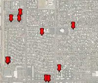
A second example illustrated pulling in Yahoo traffic (via an RSS feed) to a MapInfo map. Yahoo uses its own XML format for this data which MapInfo had to "decipher" to make the application work. Most feeds, Binyamin suggested, would need some sort of custom parsing to be fully useful. The MapInfo tool automatically pulled the central ZIP Code from the existing map, allowed for a magnification level (10 mile radius or more) and the ability to select traffic data based on severity. This tool and its source code will be included as one of the sample applications that will ship with MapBasic v8.5.
The key idea in both these, and other possible Web apps, Binyamin reinforced, is that "you get back geographic objects." The benefit, he emphasized, is that these new added data are real geographic data, data upon which further location analysis can be performed.
The other additions to MapInfo's tool chest include hosted Web services built on Envinsa or MapInfo’s MapMarker Plus. They include both multi-country, also known as "worldwide," geocoding and drive time analysis. While desktop MapInfo has had "address matching" in the core product for years, the geocoding via MapMarker Plus and Envinsa is more robust and uses a CASS certified engine. Binyamin reiterated again and again how these services are the first steps to doing any sort of analysis and that these needed to be easier for non GIS users to access and use. (The discussion reminded me quite a bit of a recent discussion with Dean Stoecker on his company's decision to make its geocoding engine available as open source code.)
The meeting with Binyamin was prompted by a comment by MapInfo CEO Mike Cattini about MapInfo support for "so called RSS" during a recent earnings call. My question at that time was whether this new release supported GeoRSS, a feed that included geographic information. The short answer: not at this time, but the core tools are there to do so. The long answer went on about when GeoRSS becomes a standard, and how it's built on GML, MapInfo's involvement in OGC, etc. As we go to press I've already seen GeoRSS support in Yahoo maps, ArcGIS Explorer and Cadcorp SIS, among others.
Moshe Binyamin, senior product manager, gave me the tour, just as the product was announced for release on June 6 of this year. In this release MapInfo laid the groundwork for the desktop product to interact with Web services of many kinds, including SOAP and XML (thus RSS). This core technology allows developers to connect MapInfo Pro to existing Web services "with a really minor development effort that utilizes XML" per Binyamin.
The first example shown was a connection to Salesforce.com, an online customer relationship management service. MapInfo developers created a sample application using MapBasic that, once loaded, allows users to access data records from a Salesforce.com account and place customer locations on the map. Alternatively, the user can directly link back and display full record information in the Salesforce.com app by clicking on the map.
 |
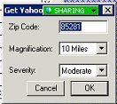 |
A second example illustrated pulling in Yahoo traffic (via an RSS feed) to a MapInfo map. Yahoo uses its own XML format for this data which MapInfo had to "decipher" to make the application work. Most feeds, Binyamin suggested, would need some sort of custom parsing to be fully useful. The MapInfo tool automatically pulled the central ZIP Code from the existing map, allowed for a magnification level (10 mile radius or more) and the ability to select traffic data based on severity. This tool and its source code will be included as one of the sample applications that will ship with MapBasic v8.5.
The key idea in both these, and other possible Web apps, Binyamin reinforced, is that "you get back geographic objects." The benefit, he emphasized, is that these new added data are real geographic data, data upon which further location analysis can be performed.
 |
The other additions to MapInfo's tool chest include hosted Web services built on Envinsa or MapInfo’s MapMarker Plus. They include both multi-country, also known as "worldwide," geocoding and drive time analysis. While desktop MapInfo has had "address matching" in the core product for years, the geocoding via MapMarker Plus and Envinsa is more robust and uses a CASS certified engine. Binyamin reiterated again and again how these services are the first steps to doing any sort of analysis and that these needed to be easier for non GIS users to access and use. (The discussion reminded me quite a bit of a recent discussion with Dean Stoecker on his company's decision to make its geocoding engine available as open source code.)
The meeting with Binyamin was prompted by a comment by MapInfo CEO Mike Cattini about MapInfo support for "so called RSS" during a recent earnings call. My question at that time was whether this new release supported GeoRSS, a feed that included geographic information. The short answer: not at this time, but the core tools are there to do so. The long answer went on about when GeoRSS becomes a standard, and how it's built on GML, MapInfo's involvement in OGC, etc. As we go to press I've already seen GeoRSS support in Yahoo maps, ArcGIS Explorer and Cadcorp SIS, among others.
From Our Homepage
Saying Farewell to an Amazing Journey
Communicating with Maps
Is There a GIS Career Ladder?
What does it mean to be geospatially smart? Series
Ways Real Estate and Property Developers Utilize Melissa GeoData for Data-Driven Decisions
Unlocking Value From Daily Satellite Imagery and Insights
Maximizing the Value of Your Address Data with Geo Addressing
How Indoor Mapping Enhances the Security of Smart Buildings
Look Ahead: AI, Location Intelligence and Efficiency
Collaboration Takes on Sea Level Rise & Dynamic Technology Environments
Brownies for Brownfields
Has Everything Been Mapped Already?
How Is Data Literacy Changing in an Artificial Intelligence Landscape
Portfolios for GIS Professionals: More Than Just Maps
How to Create a Distance Matrix in QGIS - A Step-by-Step Guide
7 Ideas for Bringing GIS into the K-12 Classroom
The Geography of Movement