 More
than 650 years ago, King Valdemar of Denmark
granted Aalborg,
then a thriving coastal village on the Limfjord, a
charter that regulated the relation between the king and the
municipality and
empowered civic leaders to provide efficient local government and
services to
its citizens.
More
than 650 years ago, King Valdemar of Denmark
granted Aalborg,
then a thriving coastal village on the Limfjord, a
charter that regulated the relation between the king and the
municipality and
empowered civic leaders to provide efficient local government and
services to
its citizens.Now the fourth largest city in Denmark, Aalborg is a model of responsible local government, as evidenced by it's hosting of the "Charter of European Cities & Towns Towards Sustainability Conference" in 1994. There, the Aalborg Charter was ratified, which encourages municipal governments to undertake environmentally sustainable programs for planning and development.
Additionally, Aalborg has implemented various GIS-based civic initiatives, including the "Active Map of Aalborg" and "Digital Democracy in Rural Areas," which endeavor to keep its citizens better informed and involved in the local decision making process by providing easier access to municipal information via the internet.
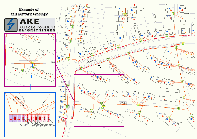
One of Aalborg's
many noteworthy endeavors is the consolidation of all municipal utility
companies
into a single agency responsible for gas, electric, district heating,
water,
wastewater, and waste disposal management. Since each of these
utilities
is similar in operation and responsibility, their unification allows
the
elimination of various redundancies common to each agency, as well as
the
creation of unique cooperative benefits. For example, the heat
produced
by the incineration of materials from household and industry waste
collection,
combined with the surplus heat generated by industry is used to supply
large-scale district heating networks.
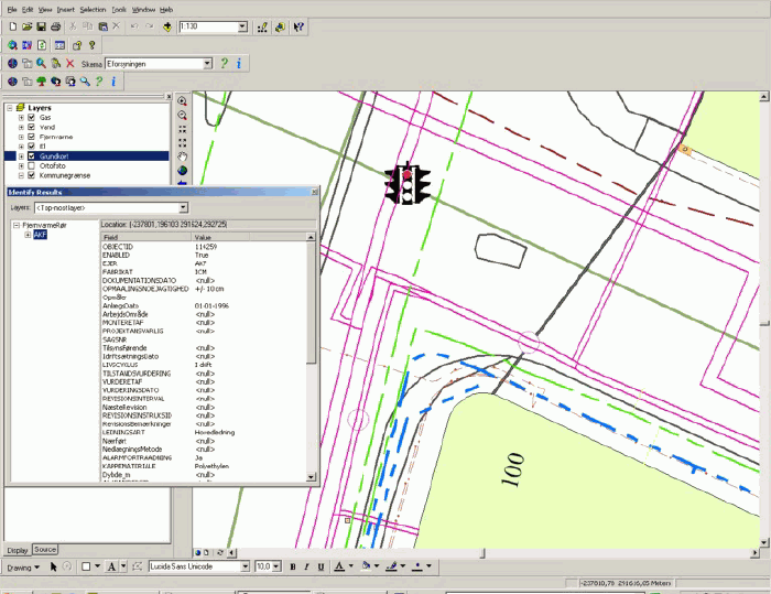
A screenshot showing a set of different utility lines. Included are district heating, power cables, water, and gas lines. You can also see an example of the technical basemap. At this time, Aalborg has almost 600 different feature classes with much intelligent data. Some of the feature classes contain data that comes from integration with other systems like SCADA, billing systems, network-modeling systems, separate databases, and so on.Click image for larger view.
A key
element of the amalgamated Aalborg
utility agency is the centralization of all GIS
efforts.GIS data and services are provided by a single
department, which
insures that each of the utilities is working from the same updated
maps and
data. This has further allowed the Aalborg
municipality to streamline government and improve services by making
critical
information more readily available to the various city
departments. The
departments are connected to one another with a 1Gbit
network for high-speed communication. In
conjunction with the centralization of its public utilities, the
municipality
established a management team to develop long-term strategies to
increase
efficiency through automation and restructured operating procedures. The management team identified GIS as a
strategic tool in its modernization efforts and the technology is now
promoted
throughout the entire public utility organization. The city
began automating its utility database
with the digitizing of its pipeline network in 1988.In 1996, it
purchased ESRI's ArcInfo GIS software.Three years later, after
the
development of its extensive geo-database, the GIS department began
creating
utility specific data models. The Aalborg
GIS is extensive, containing almost
600 different feature classes within its geo-database, which is updated
on a
daily basis. Some of the feature classes include data that comes
from the
integration with other systems, including Supervisory Control and Data
Acquisition (SCADA), customer billing systems, network modeling
systems,
cadastral data, aerial photography, technical basemaps, separate
databases, and
many others.
Jens Henrik Sørensen, Project Manager of the Aalborg GIS Department, comments on the direction of the department as the Aalborg GIS continues to evolve."Because of the strict requirements to integrate other systems and databases with our GIS, the complexity of our existing spatial databases, and the ongoing need to contain costs, our methodology is to implement a collection of standard data models for our GIS to increase the efficiency and capabilities of our system."
The municipality began to construct functionally integrated and coherent data models to support the development of its spatial databases.The designs needed to be dynamic and compatible with existing data.
The initial model was for its gas utility and was developed with the help of Miner & Miner, an American firm specializing in the implementation of GIS utility applications.The model was implemented in 2000 and was followed by the development of a water distribution model that was completed in 2001 with the help of ESRI.Since then, its district heating and electricity models have also been completed.The municipality's wastewater, communications, and cadastral models are all currently under development.
Sørensen
continues, "Developing our GIS with the use of data
models has given us the opportunity to jumpstart our projects.The
models
give us a high degree of flexibility and more freedom in the comparison
and
analysis of our data.They are working particularly well for our
municipality because we have centralized our databases, which allows us
to
provide the most current versions of the data to our users with the
least
amount of duplication."

The dynamic capabilities of the Aalborg GIS are already providing substantial benefits to the city.For example, today standard measurements indicating the location of district heating utility lines and fittings include Z values, which facilitates the calculations of pressure and temperature for network modeling.However, Aalborg's original district heating data did not include accurate Z values.The Aalborg GIS department calculated this essential information by interpolating Z values from a laser-scanned digital terrain model (DTM) and then subtracted the measured depth under terrain.The new Z value is written back to the database with supplemental information about the calculation method and the terrain model used.
Comments Sørensen, "Our network modeling system is able to perform a similar calculation, but doing the job directly in the GIS is far more efficient and the result is documented in the correct manner."
Aalborg has also integrated their GIS with their financial system, which provides them with a spatially enabled assets management tool, allowing a complete overview of the municipality's assets from a geographical perspective.This includes a detailing of all in ground infrastructure, such as pipelines, their age, condition, expected lifespan, and so on.
Continues Sørensen; "Sometimes it is necessary to remove existing infrastructure, such as a pipeline, before its anticipated lifespan is over.Once it is removed, however, the pipe must be accounted for in our financial system.For example, suppose an existing pipe is expected to last for 30 years, but because of urbanization, the city finds it necessary to remove the pipeline after just 10 years.In addition to physically removing the pipeline, it has to be removed from the financial overview so that the municipality can maintain a very precise record of its physical assets.The assets are reflected in the city's tax base and are essential in determining tax rates and projected city revenues."
The department's GIS software installation includes three licenses for ArcSDE (one for production, one for testing purposes, and one to manage ArcIMS), Oracle for its database management system, ArcIMS for managing spatial data on the internet, ArcFM from Miner & Miner for AM/FM applications, Spatial Analyst, and ArcGIS components: ArcInfo, ArcEdit, and ArcView.
Special applications for the Arc suite include object seeking, GIS annual accounts, annotation tools, plot tools, map book tools (operational map applications), conversion tools, edit tools, especially for the maintenance of the electricity data model, and integration with other platforms, such as billing and SCADA systems.By integrating their GIS with these enterprise systems, the municipality of Aalborg has not only developed a highly intelligent database, but also a network surveillance system that allows supervisors to continually monitor all transactions throughout their system and perform any necessary analysis and control procedures.For example, the real-time SCADA system can determine whether or not a leak it has recorded is critical and requires immediate attention and then displays the information it has collected in a logical and organized fashion in the GIS so that remedial action can be performed, if necessary.In addition, the network calculation application can accurately predict the future of the network by projecting loads and potential switching using GIS applications.
In the near future, contractors will also make use of the GIS system.For example, a request to perform routine maintenance work on a pipeline will be submitted electronically to the municipality, where it will be recorded and analyzed by the system to determine the optimum time period to conduct the work with minimum disruption. Permission to perform the work will either be granted or denied online, which will greatly speed up the project approval process and minimize paperwork.In the event of a construction emergency, the GIS will generate mailing lists of effected residences for immediate notification.
Other departments within the municipality, such as the fire department, use base maps generated by the GIS department for routing purposes, as well as determining the location of water lines.Aalborg's fire departments have indicated that they have plans to implement GIS in the future.
It is anticipated that in the future, the Aalborg GIS department will make greater use of mobile GIS systems with Global Positioning System (GPS) capabilities, such as ArcPad, so that employees in the field can have ready access to the municipality's geo-database for reference and on the spot updating purposes, in addition to those departments requiring immediate locational information for emergency services.
Sørensen believes that the use of GIS will expand rapidly in Denmark, due in part to the national cadastre database the national government committed to building almost 15 years ago.The cadastre is highly detailed, includes aerial photography of the entire country, and is available in multiple resolutions, providing the opportunity for a number of new GIS-based initiatives to be implemented.
Concludes Sørensen, "I believe that with the active support of our national government for spatial technology initiatives and the increasing opportunity for GIS education in our secondary schools and universities, the technology will continue to migrate from GIS applications to strategic problem solving systems that are spatially enabled."