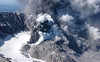
 On
May 18, 1980, Mount St.Helens erupted producing a cataclysmic mixture
of ash, rock debris and hot gases (nuees ardentes) cascading down the
northern slopes of the volcano, essentially blowing out the side of the
mountain and killing 57 people.Today, the mountain is reigniting
interest in volcanology as it spews ash and steam from the lava plug
that caps the crater, threatening to erupt violently again.Recent seismic
activity indicates that magma is moving up the neck of the volcano,
closer to the surface spawning numerous earthquakes of low magnitude.
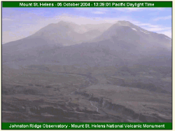
The image at right was taken on October 2, 2004 by DigitalGlobe's
QuickBird satellite (click for larger image) of the crater's center.
On
May 18, 1980, Mount St.Helens erupted producing a cataclysmic mixture
of ash, rock debris and hot gases (nuees ardentes) cascading down the
northern slopes of the volcano, essentially blowing out the side of the
mountain and killing 57 people.Today, the mountain is reigniting
interest in volcanology as it spews ash and steam from the lava plug
that caps the crater, threatening to erupt violently again.Recent seismic
activity indicates that magma is moving up the neck of the volcano,
closer to the surface spawning numerous earthquakes of low magnitude.
The image at right was taken on October 2, 2004 by DigitalGlobe's
QuickBird satellite (click for larger image) of the crater's center.In 1980, I had the good fortune of working beside some of the preeminent volcanologists in the country at Dartmouth College as a graduate student when St.Helens erupted.Dick Stoiber (dec.), professor of geology at Dartmouth, was one of the first geologists on the scene in 1980 and subsequently published several papers marking the event.
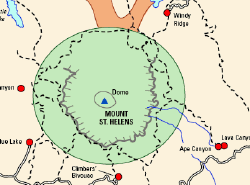
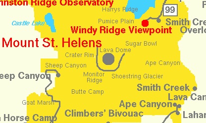
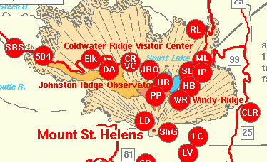
Prior to the major eruption that year, Dartmouth was working with the U.S.Geological Survey (USGS) in monitoring the sulfur dioxide gases emanating from the gas plumes.Emissions of SO2 gases were known to be indicators of a possible eruption.David Johnston, a geologist with the USGS was on the ground monitoring the gases only a few miles from the mountain's summit when the eruption occurred.Dr.Johnston was killed that day and the current, live VolcanoCam from Johnston's Ridge is named in memoriam for him.On October 2 of this year, the USGS issued a Level III Volcano Alert, which included the evacuation of the Johnston Ridge Observatory, which is located at approximately 4,500 feet and five miles from the center of the crater. The volcano's summit is 8,364 feet and stood at 9,677 feet before the 1980 eruption.
Directions Magazine presents several map resources from the USGS, NASA, and the US Forest Service for readers interested in following the eruption activity and, in particular, viewing some of the online web maps that are available:


Mount St.Helens - May 18, 1980 Eruption Maps and Graphics - Courtesy of the USGS
- Graphic [20K,InlineGIF]: Generalized North-South Geologic Cross Sections Through Mount St.Helens -- Modified from: Doukas, 1990, USGS Bulletin 1859
- Pictogram [100K,InlineGIF]: Mount St.Helens May 18, 1980 Eruption Sequence -- "Pictogram" by Lyn Topinka, 1998, Modified from: Brantley and Topinka, 1984, Earthquake Information Bulletin v.16, no.2
- Map [21K,InlineGIF]: Mount St.Helens area showing May 18, 1980 devastation -- Modified from: Tilling, Topinka, and Swanson, 1990
- Map [14K,InlineGIF]: Distribution within the United States of May 18, 1980 ash fallout from Mount St.Helens -- Modified from: Tilling, Topinka, and Swanson, 1990
- Map [22K,InlineGIF]: May 18, 1980 Ash Plume Path -- Modified from: Sarna-Wojcicki, et.al., 1981, IN: USGS Professional Paper 1250
- Map [32K,InlineGIF]: Lakes North of Mount St.Helens Affected by the May 18, 1980 Eruption -- Modified from: Dion and Embrey, 1981, USGS Circular 850-C, and Embrey and Dion, 1988, WRI-87-4263
- Graphic [18K,GIF]: Surface-water temperatures of Spirit Lake before (1974) and after (1980) the May 18, 1980 eruption of Mount St.Helens -- Modified from: Dion and Embrey, 1981, USGS Circular 850-G
- Graphic [18K,InlineGIF]: Plot of thickness vs.distance from vent for several tephras from Cascade Range volcanoes. -- Modified from: Hoblitt, et.al., 1987, USGS Open-File Report 87-297
- Schematic [13K,GIF]: stratigraphic section in Harry Gardner Park. -- L, lithic-rich layer; P, pumice-rich layer.-- Modified from: Doukas, 1990, USGS Bulletin 1859
![Graphic [18K,GIF]: Surface-water temperatures of Spirit Lake before (1974) and after (1980) the May 18, 1980 eruption of Mount St.Helens](http://vulcan.wr.usgs.gov/Imgs/Gif/MSH/Hydrology/Lakes/spirit_lake_1980_temperatures.gif)
![Schematic [13K,GIF]: stratigraphic section in Harry Gardner Park.](http://vulcan.wr.usgs.gov/Imgs/Gif/MSH/Graphics/EruptiveHistory/sft_bridge.gif)
- Schematic [22K,GIF]: Dome Growth 1980-83 - Ground Profile -- Taken from tracings of photographs from fixed photo station on crater floor, approximately 1 kilometer north of center of dome.Products of each extrusive episode include talus that accumulated during that episode. Scale varies owing to perspective view; true east-west basal diameter of dome in December 1983 was about 830 meters.-- Modified from: Swanson, et.al., 1987, IN: GSA Special Paper 212
- Schematic [10K,GIF]: Dome Growth 1980-86 - Yearly Ground Profile -- Taken from tracings of photographs from fixed photo station on crater floor, approximately 1 kilometer north of center of dome.Includes accumulated talus.Scale varies owing to perspective view.Approximate 1986 east-west basal diameter of dome was about 860 meters.-- Modified from: Topinka, 1992, IN: USGS Bulletin 1966
- Schematic [14K,GIF]: Lobe Development - Aerial View - Schematic drawings of lobe development in the growth of a lava dome, as traced off aerial photographs of Mount St.Helens Lava Dome, 1980-1981.-- Modified from: Swanson, et.al., 1987, IN: GSA Special Paper 212
- Schematic [12K,GIF]: Emerging New Lobe, August 1982 -- Taken from tracings of photographs from photo station on crater floor, showing 1-day and 2-week intervals.-- Modified from: Topinka, 1992, IN: USGS Bulletin 1966
![Schematic [22K,GIF]: Dome Growth 1980-83 - Ground Profile](http://vulcan.wr.usgs.gov/Imgs/Gif/MSH/Graphics/Domes/dome_growth_schematic_80-83.gif)
![Schematic [10K,GIF]: Dome Growth 1980-86 - Yearly Ground Profile](http://vulcan.wr.usgs.gov/Imgs/Gif/MSH/Graphics/Domes/dome_growth_schematic_80-86.gif)
![Schematic [14K,GIF]: Lobe Development - Aerial View](http://vulcan.wr.usgs.gov/Imgs/Gif/MSH/Graphics/Domes/msh_lobes_80-81.gif)
![Schematic [12K,GIF]: Emerging New Lobe, August 1982](http://vulcan.wr.usgs.gov/Imgs/Gif/MSH/Graphics/Domes/emerging_lobe_aug82.gif)
Other resources
Mount St.Helens Resources/Publications
Stoiber, R.E., Williams, S.N., Malinconico, L.L., Johnston, D.A., and Casadevall, T.J., 1981, Mount St.Helens: Evidence of increased magmatic gas component: Jour. Volcanol.Geotherm.Res., v.11, no.4, p.203- 212.
Casadevall, T.J., Johnston, D.A., Harris, D.M., Rose, W.I., Jr., Malinconico, L.L., Stoiber, R.E., Bornhorst, T.J., Williams, S.N., Woodruff, L., and Thompson, J.M., 1981, SO2emission rates at Mount St.Helens from 29 March through December, 1980: USGS Prof.Paper 1250, Lipman, P.W.and Mullineaux, D.R.(eds.), p.193- 200.
Stoiber, R.E., Williams, S.N., and Malinconico, L.L., 1980, Mount St.Helens, Washington 1980 eruption: the magmatic gas component during the first 16 days: Science, v.208, no.4449, p.1258- 1259.
From Our Homepage
Saying Farewell to an Amazing Journey
Communicating with Maps
Is There a GIS Career Ladder?
What does it mean to be geospatially smart? Series
Ways Real Estate and Property Developers Utilize Melissa GeoData for Data-Driven Decisions
Unlocking Value From Daily Satellite Imagery and Insights
Maximizing the Value of Your Address Data with Geo Addressing
How Indoor Mapping Enhances the Security of Smart Buildings
Look Ahead: AI, Location Intelligence and Efficiency
Collaboration Takes on Sea Level Rise & Dynamic Technology Environments
Brownies for Brownfields
Has Everything Been Mapped Already?
How Is Data Literacy Changing in an Artificial Intelligence Landscape
Portfolios for GIS Professionals: More Than Just Maps
How to Create a Distance Matrix in QGIS - A Step-by-Step Guide
7 Ideas for Bringing GIS into the K-12 Classroom
The Geography of Movement