Autodesk was to roll out the latest AutoCAD next week, but a series of leaks opened the floodgates of information more than a week early.With Autodesk's permission then, here's a first look at the new Infrastructure Solutions Division products, expected to be available in mid-April.Coming off its first $1 billion year, company president and CEO Carol Bartz described the 2006 family as its "strongest portfolio ever."
The State of ISD
At a briefing held on February 25, Vice President of the Infrastructure Solutions Division (ISD), Chris Bradshaw, clarified some of comments made during an earnings call for the fourth quarter of 2004.First off, he explained the different ways Autodesk describes how customers "come to acquire" an Autodesk vertical product.Those who move from one Autodesk product to another, (from AutoCAD to Map for example, are considered "crossgraders." Those who move from Map 2005 to Map 2006 "upgrade" and those who "pay full price" are considered "new seats." That's important in ISD since the number of new seats was up 20% from the last quarter.The new seats, Bradshaw explained, are across all the key market segments with government perhaps leading the pack.The new seats are from existing and new customers.When asked if the new seats are coming from "switchers" from competitors or those without parallel products, Bradshaw explained it was "his sense" that most were companion purchases, ones that "sat beside" an existing GIS implementation.
Bradshaw reiterated the Autodesk vision of an open and central data store allowing data sharing as the future of the enterprise.(That's to be contrasted with many different users sharing data directly with one another.) Autodesk has been offering this vision for ISD for some time but with minimal detail.Still, the clients to that central data store are maturing with each new release of AutoCAD, including Civil3D and Map 3D.
Civil 3D 2006
Civil 3D 2006 is the second product with this new monicker.(Land Desktop 2006 is also expected in April.) The latest incarnation is built on the new AutoCAD Map 3D 2006 which is in turn built on the new AutoCAD 2006.The underlying technology that makes this product different is its "dynamic relationship between objects." ("Everything knows about everything else and updates accordingly.") There are new tools for working with pipes (for those working with sanitary and water networks), enhanced corridor modeling (for linear features like railroad tracks), expanded multi-user access (which seemed to boil down to enhanced Xrefs, but ones that "maintain object smarts" when attached to a drawing), and an expanded API.Autodesk boasted about a study of the previous version (Civil 3D 2005) that showed tremendous productivity gains with the product: 100% productivity increases and 14% revenue increases were two statistics that flew buy in a PowerPoint slide.The whole report is available from Autodesk and a new one examining Civil3D 2006 is in the works.
Autodesk Map 3D 2006
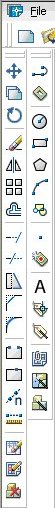 |
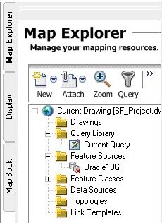
The new interface aims to reduce "visual competition." And, instead of AutoCAD's default black drawing area, sports a blue one.(Envision, Autodesk's "less CAD-like" desktop GIS, also has a blue drawing area.) The rest of the interface includes tools on the left, updated menus on the top and a Map Explorer, Display Manager, and MapBook tool tabbed on the right.The pull-down menus are thankfully not the old AutoCAD menu with a single pull-down called "Map" which has been around since the first versions of of the product.The menus are actually arranged in a more logical way with "create," "modify" and "analyze" pull-downs revealing commands for just those types of work.
 |
One other big change for longtime AutoCAD users: there's no command line, by default.Inputs are "keyed in" at the cursor for a "heads up" experience.Other CAD packages have had that for sometime.
While I believe these changes are a step forward, I hoped for more workflow-type help in the interface, to guide a user through the steps of an analysis, for example.I believe the many steps involved in actually getting work done are the biggest challenge to new users.
The enhanced support for Oracle and the newly added support for ArcSDE will be welcome in shops that use the database and database extension, respectively, to store and manage spatial data.Again, this positions Autodesk Map 3D 2006 as fine "companion seat" or editor for data in ArcSDE.(ESRI had offered CAD Client as a stand alone product to allow both AutoCAD and MicroStation to read and write data stored in ArcSDE.It's now included with ArcSDE.) Support for ArcSDE does not, however, put Autodesk head to head with Bentley and its GIS*Connect which (because it works through ArcGIS) can edit ESRI geodatabases as well as ArcSDE data.
Autodesk Map 3D 2006 also includes enhanced visualization and presentation tools including an updated application to build MapBooks, either printed ones or electronic ones, using DWF.The new MapBook tool is built on AutoCAD's sheet set management tools introduced in AutoCAD 2005.When I saw that for the first time (Dec 2003) one of my questions was, "Will this be enhanced specifically for map production?" The answer is yes.
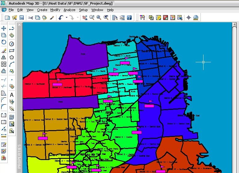 |
The short demonstration involved finding schools in school districts in San Francisco.Data was accessed via Oracle 10g and ESRI Shape files, stylized, labeled etc.I have to say that while one could do this sort of analysis with Autodesk Map 3D 2006, it's not its best use.That sort of analysis might be done with Envision or another desktop GIS far more simply and quickly.Further, a quick look at the output suggests that "pretty output" might take some work in Autodesk Map 3D.
While I applaud Autodesk adding features to both packages and appreciate that Autodesk Map 3D 2006's interface is changing for the better, there's still a ways to go to make Autodesk Map as "GIS friendly" as most desktop GIS products.