NOAA Satellite Captures Northeast U.S.Blackout

August 17, 2003
Share

Sharing is Caring

NOAA Captures NorthEast Blackout
NOAA posted these satellite images online taken before and after of the historic blackout of the Northeastern United States, which plunged millions of people into darkness.NOAA processed the night lights data taken by the Defense Meteorological Satellite Program (DMSP).NOAA archives the data from the satellite.The image below is a view of the Northeastern USA taken Aug.14, 2003, at 9:03 p.m.EDT.
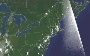
Click above for larger (low resolution) image
Clich HERE for a high resolution image.

Before the blackout images
Click below on the image for larger view (low resolution) of night lights before the blackout in the Northeastern USA taken Aug.13, 2003, at 9:21 p.m.EDT.
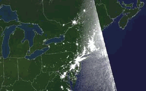
Click HERE for higher resolution of the image above; NOAA processed the data from the Defense Meteorological Satellite Program.

For more image from NOAA, click HERE.

Images coutesy of NOAA/DMSP

Share

Sharing is Caring

Explore more: GEOINT, Remote Sensing

Geospatial Newsletters

Keep up to date with the latest geospatial trends!

Sign up

Search DM

Get Directions Magazine delivered to you
Please enter a valid email address
Please let us know that you're not a robot by using reCAPTCHA.
Sorry, there was a problem submitting your sign up request. Please try again or email editors@directionsmag.com

Thank You! We'll email you to verify your address.

In order to complete the subscription process, simply check your inbox and click on the link in the email we have just sent you. If it is not there, please check your junk mail folder.

Thank you!

It looks like you're already subscribed.

If you still experience difficulties subscribing to our newsletters, please contact us at editors@directionsmag.com