Adena Schutzberg attended the ESRI Federal User
Conference last week in Washington, D.C. Here is a summary of some
interesting things she found at the exhibit.
Rumors of Informix Death are Premature
Back in the day, Informix was one of the most solid databases with a geospatial storage solution. IBM acquired Informix in 2001 and then things got very quiet. That doesn't mean it went away, rather it meant that IBM, which does not do product marketing, didn't tout it very much. Still, its hard core users continued to use it and pay IBM. I spoke to Robert Uleman in IBM's booth. He is with the company's Geospatial Data Management group, and he explained that one user runs 10,000 instances with just eight database administrators (that's detailed in this article). He said it runs "almost unattended."
Informix's geospatial capabilities grew out of a NASA requirement to manage large global datasets. Its ability to store data in a "round earth" (that is, in geographic coordinates, obviating the complexities of International Datelines for example) makes it ideal for those with large imagery sets such as the German Space Agency, the National Geospatial-Intelligence Agency (NGA), those with weather data and the like. And, it helps to solve the "what projection do we store the data in?" question. The answer: in geographic coordinates, which are then projected on the fly as needed for the geography in question. The "round earth" vision is compelling enough that IBM implemented it in DB2, as well. Uleman notes that as businesses (and governments for that matter, I suppose) become more global and thus manage global geodata sets (including data about their inventories, etc.), the need for this sort of storage will grow. He is even mulling updates to existing OGC specifications to support this sort of storage.
The money Informix generated during the quiet period between 2001 and 2005 caught IBM management's eye in 2005 and it started to revisit the product, and license numbers have grown. By summer of this year the new "Cheetah" release is expected. While updates in recent years focused on user requests alone, the new release will be a big step forward. The release will focus on making Informix's unique features more accessible and from the geospatial side, highlighting its integration capabilities via its OGC Web Services support. Uleman's parting comment to me was, "Your data has to live in the globe." Indeed!
BAE Offers Exploitation Solution
BAE is moving functionality from its well respected VITec Electronic Light Table (ELT) geospatial exploitation software, mostly used in the military, to a new product, Socet GXP. It's a companion to Socet Set, the company's flagship product for image processing (stereo, image rectification, DEM creation, 3D compilation, etc.) aimed at image exploitation. The product allows analysts to easily explore one or more images to find features of interest. It can trace a path to allow the analyst, for example, to fly down the shoreline or compare images for a quick change detection exploration. One big plus is the fact that the image is always in "world space," that is, in real world coordinates, while in use.
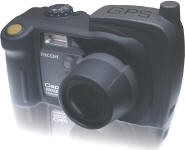
Ricoh's Latest Tough GPS-enabled Camera
I got to see Ricoh's new GPS-enabled camera, the Ricoh 500SE,
in the flesh. Expected availability is mid-January. The drop resistant,
waterproof camera combines the best features of a GPS data collector
and a digital camera. The camera with embedded GPS (about $1,050 with
GPS, camera also available for $900 without GPS) offers two to five
meter accuracy. It also sports Bluetooth and wireless connectivity to
support external GPS receivers with higher accuracy. Images can be
"beamed" to a device after capture using these connections. In addition
to standard GPS data, other attributes can be embedded in the EXIF
header. These are selected by the shooter from 'pre-set up' fields with
dropdown menus. Alternatively, the user can record voice notes about
the image and key them in later. Setting up the camera is very much
like setting up a GPS for data capture in the field.
Once captured, images can be downloaded along with a corresponding KMZ, shape file or Excel spreadsheet. These allow for instant availability on a map. The idea, explained Todd Lushinsky, is to enhance the existing, likely not-so-slick workflow of taking GPS-tagged images. One feature of note, requested by fire departments in Japan, puts the camera in mode to take pictures in smoky areas. How does it work? Instead of autofocus (which would see smoke and try to focus on it), it uses a fixed focus to look "through" the smoke.
Leica Enhances User Experience
Leica continues to enhance its "soup to nuts" offering for image collection and use. Users can collect data with an ADS-40 sensor, use Leica Photogrammetry Suite (LPS) to process the raw imagery, and draw on the flagship product IMAGINE for image analysis. The most recent releases of LPS and IMAGINE focus on simplifying the workflow for the user, or said more simply, "doing more with fewer clicks." That's the sign of a mature product suite, though enhancement in the core such as adding more data formats and squashing bugs continues with each release. What's ahead? Look for Leica, like the rest of the industry, to further explore client server solutions and Web services.
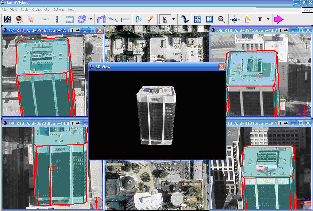
MultiVisionUSA Shows off Obliques and 3D Models
MultiVisionUSA began offering its oblique image solution in the U.S. just 20 months or so ago. Clients already number in the teens. I asked Bob Rolfe, regional sales manager, how those interested in oblique imagery should evaluate the offerings out in the marketplace. He pointed to three things:
WeatherBug: Better Weather
With all the services offering real time weather, it can be tough to figure out which one to use. Christian Solomine gave me the lowdown on how WeatherBug is different. First of all, it will feed data to ArcGIS. Second, the company has 8,000 of its own sensors which are updated every two minutes, quite different from the National Weather Services sensors at airports which are updated far less frequently. He was quick to point out that for some applications, free weather is just fine, but his customers need timelier, more local data. Third, the company has more than 1,000 weather cameras. What do the cameras look at? The horizon. Why? Because things like fog can be tough to evaluate unless you can see them.
Hottest Thing on the Floor: Watermarking Your Digital Images
GeoMarc is technology to embed information in the pixels of an image, an invisible "watermark." What sort of information? Ownership information to track use of rights restricted imagery. Links to external documents that store the different image manipulations the image has been through.
And, get this, the "watermark" stays with the image even if it's converted to another form or printed and scanned back in! The technology is actually a few years old, but it is just out in its second (more mature) release.
Rumors of Informix Death are Premature
Back in the day, Informix was one of the most solid databases with a geospatial storage solution. IBM acquired Informix in 2001 and then things got very quiet. That doesn't mean it went away, rather it meant that IBM, which does not do product marketing, didn't tout it very much. Still, its hard core users continued to use it and pay IBM. I spoke to Robert Uleman in IBM's booth. He is with the company's Geospatial Data Management group, and he explained that one user runs 10,000 instances with just eight database administrators (that's detailed in this article). He said it runs "almost unattended."
Informix's geospatial capabilities grew out of a NASA requirement to manage large global datasets. Its ability to store data in a "round earth" (that is, in geographic coordinates, obviating the complexities of International Datelines for example) makes it ideal for those with large imagery sets such as the German Space Agency, the National Geospatial-Intelligence Agency (NGA), those with weather data and the like. And, it helps to solve the "what projection do we store the data in?" question. The answer: in geographic coordinates, which are then projected on the fly as needed for the geography in question. The "round earth" vision is compelling enough that IBM implemented it in DB2, as well. Uleman notes that as businesses (and governments for that matter, I suppose) become more global and thus manage global geodata sets (including data about their inventories, etc.), the need for this sort of storage will grow. He is even mulling updates to existing OGC specifications to support this sort of storage.
The money Informix generated during the quiet period between 2001 and 2005 caught IBM management's eye in 2005 and it started to revisit the product, and license numbers have grown. By summer of this year the new "Cheetah" release is expected. While updates in recent years focused on user requests alone, the new release will be a big step forward. The release will focus on making Informix's unique features more accessible and from the geospatial side, highlighting its integration capabilities via its OGC Web Services support. Uleman's parting comment to me was, "Your data has to live in the globe." Indeed!
BAE Offers Exploitation Solution
BAE is moving functionality from its well respected VITec Electronic Light Table (ELT) geospatial exploitation software, mostly used in the military, to a new product, Socet GXP. It's a companion to Socet Set, the company's flagship product for image processing (stereo, image rectification, DEM creation, 3D compilation, etc.) aimed at image exploitation. The product allows analysts to easily explore one or more images to find features of interest. It can trace a path to allow the analyst, for example, to fly down the shoreline or compare images for a quick change detection exploration. One big plus is the fact that the image is always in "world space," that is, in real world coordinates, while in use.
Ricoh's Latest Tough GPS-enabled Camera
 |
Once captured, images can be downloaded along with a corresponding KMZ, shape file or Excel spreadsheet. These allow for instant availability on a map. The idea, explained Todd Lushinsky, is to enhance the existing, likely not-so-slick workflow of taking GPS-tagged images. One feature of note, requested by fire departments in Japan, puts the camera in mode to take pictures in smoky areas. How does it work? Instead of autofocus (which would see smoke and try to focus on it), it uses a fixed focus to look "through" the smoke.
Leica Enhances User Experience
Leica continues to enhance its "soup to nuts" offering for image collection and use. Users can collect data with an ADS-40 sensor, use Leica Photogrammetry Suite (LPS) to process the raw imagery, and draw on the flagship product IMAGINE for image analysis. The most recent releases of LPS and IMAGINE focus on simplifying the workflow for the user, or said more simply, "doing more with fewer clicks." That's the sign of a mature product suite, though enhancement in the core such as adding more data formats and squashing bugs continues with each release. What's ahead? Look for Leica, like the rest of the industry, to further explore client server solutions and Web services.
MultiVisionUSA Shows off Obliques and 3D Models
MultiVisionUSA began offering its oblique image solution in the U.S. just 20 months or so ago. Clients already number in the teens. I asked Bob Rolfe, regional sales manager, how those interested in oblique imagery should evaluate the offerings out in the marketplace. He pointed to three things:
- Evaluate ease of use of the off-the-shelf software
- Consider how well the system integrates with other systems in use (like CADD or GIS)
- Explore how licensing is done (Who owns the data? Are there fees for multiple users? Multiple servers?)
 |
|
With all the services offering real time weather, it can be tough to figure out which one to use. Christian Solomine gave me the lowdown on how WeatherBug is different. First of all, it will feed data to ArcGIS. Second, the company has 8,000 of its own sensors which are updated every two minutes, quite different from the National Weather Services sensors at airports which are updated far less frequently. He was quick to point out that for some applications, free weather is just fine, but his customers need timelier, more local data. Third, the company has more than 1,000 weather cameras. What do the cameras look at? The horizon. Why? Because things like fog can be tough to evaluate unless you can see them.
Hottest Thing on the Floor: Watermarking Your Digital Images
GeoMarc is technology to embed information in the pixels of an image, an invisible "watermark." What sort of information? Ownership information to track use of rights restricted imagery. Links to external documents that store the different image manipulations the image has been through.
And, get this, the "watermark" stays with the image even if it's converted to another form or printed and scanned back in! The technology is actually a few years old, but it is just out in its second (more mature) release.
From Our Homepage
Saying Farewell to an Amazing Journey
Communicating with Maps
Is There a GIS Career Ladder?
What does it mean to be geospatially smart? Series
Ways Real Estate and Property Developers Utilize Melissa GeoData for Data-Driven Decisions
Unlocking Value From Daily Satellite Imagery and Insights
Maximizing the Value of Your Address Data with Geo Addressing
How Indoor Mapping Enhances the Security of Smart Buildings
Look Ahead: AI, Location Intelligence and Efficiency
Collaboration Takes on Sea Level Rise & Dynamic Technology Environments
Brownies for Brownfields
Has Everything Been Mapped Already?
How Is Data Literacy Changing in an Artificial Intelligence Landscape
Portfolios for GIS Professionals: More Than Just Maps
How to Create a Distance Matrix in QGIS - A Step-by-Step Guide
7 Ideas for Bringing GIS into the K-12 Classroom
The Geography of Movement