Oracle conducted its annual Oracle
Spatial User Conference following the GITA conference in Seattle on
March 13.
From the outset, it was clear that Oracle is continuing its rapid move
from simply supporting core spatial data types (SDO Geometry) for
spatial data management to offering "full blown" application suites. Last
year's meeting revealed the beginning of this trend. This year's
customer and partner presentations further illustrated the move. "We've
now defined the platform; what we have done is become leaders in
'location enabling' and bringing this application to every organization
that wants to build upon it," said Dr. Xavier Lopez, director of
product management, Spatial and Semantic Technologies for Oracle.
Oracle is spatially enabling its core Oracle Business Intelligence Enterprise Edition platform (OBIEE, formerly Siebel Analytics), integrating interactive mapping and location based analysis and reporting into enterprise dashboards. In addition, Oracle is integrating its vertical applications with its geospatial technology in areas such as customer relationship management (CRM), utility outage management, asset management, customer billing and regulatory compliance.
But now there is increased competition. With the upcoming release of Microsoft SQL Server 2008 and the availability of some popular open source solutions such as PostgreSQL and MySQL (recently acquired by Sun Microsystems), there are alternatives to Oracle Spatial. Oracle announced to its users that it believes the SQL Server spatial capabilities will be a low end offering similar to, but somewhat less functional than, the basic Oracle Locator functionality included in all editions of Oracle Database, based on initial announcements by Microsoft. Lopez said that Oracle is focused on both on providing these core location capabilities in every edition of its database as a non-priced feature and continuing to advance its Oracle Spatial option for the "high-end," applications, particularly those solutions that need enterprise-class geospatial processing." He also said that with each new release, Oracle reviews the features in Locator in order to maintain a strong competitive position.
Oracle Spatial and 3D
Oracle placed a good deal of emphasis on the ability to import and export 3D data. In 11g, you can also import and export GML but there is export support only for KML and COLLADA, a digital asset exchange format for 3D data. Oracle has made the beta version of the Oracle GeoRaster Java API available within the last week; it can be downloaded from the Oracle Spatial website. Dale Lutz of Safe Software discussed FME support for Oracle 3D data types and how to move building information model (BIM) data in and out of Oracle.
Oracle Maps as a Component of BI
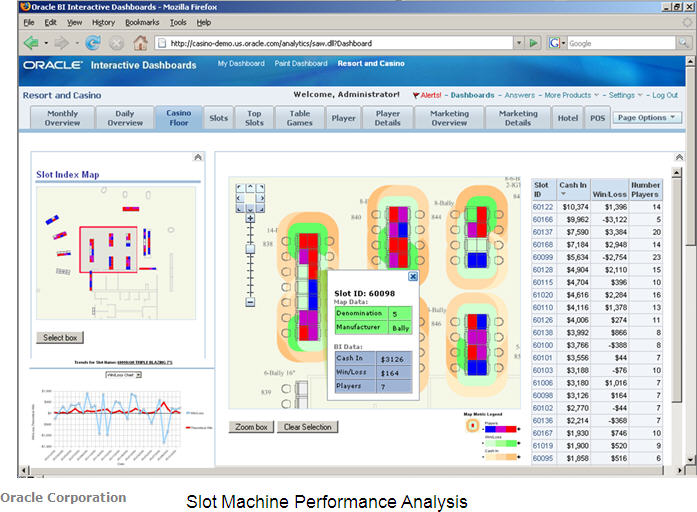
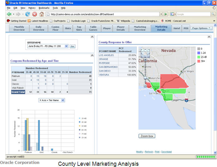
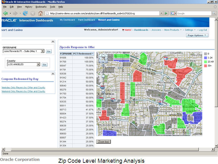
The OBIEE platform accesses diverse business data sources to deliver visualizations typical of a BI environment, including pivot tables and charting. David Lapp of Oracle demonstrated how a casino could integrate Oracle Maps into OBIEE interactive dashboards to visualize the gaming performance of not just the entire casino, but specifically the overall performance at individual tables. He provided a high-level view of the casino floor and showed how a casino manager would monitor the amount of money going into and out of slot machines, drilling deeper for more detail. It was a unique demonstration of facility level "microgeography" applications and the ability to extract data that a business manager would find useful. Within the same dashboard he showed integration of geographic maps supporting the analysis of marketing performance by county and ZIP Code, thereby reinforcing the ability to utilize Oracle Spatial and Oracle Maps at both the facility and geographic levels.
Vertical Applications
Bruce Kane, director of product management for Oracle Utilities Mobile Workforce Management (MWM), provided insight into Oracle's approach to the utility industry. MWM comprises three products: Oracle Utilities MWM Real time Scheduling, Oracle Utilities MWM Dispatch, and Oracle Utilities MWM Automated Vehicle Locator. The MWM solution stack now includes integration with Oracle Application Server MapViewer. Kane's demo showed Gantt charts that illustrated the work order for dispatch crews; it showed a map and tabular view of work orders indicating whether crews were onsite and whether work had been assigned to certain crews. The map view also displayed service centers, crews and orders, as well as the option to see a variety of other attributes that could be displayed spatially, so that a dispatcher could see what was going on in a service territory. To support more efficient business processes, the MWM solution can look to see if the crews used the most cost-effective routes throughout the day, as it can pull the history from GPS receivers.
Jim Kowalski, COO of thincSoft, an Oracle partner, discussed putting "Business Intelligence on the map in retail." Kowalski showed thematic maps of retail stores color coded by performance, compared with same-store sales during a previous time period. The most interesting part of his demo was not just a "deep dive" into specific stores, but also a mapping of the store floor to show sales by shelf location. This "microgeographic view" of a retail store is the science of using planograms to position products and sell shelf space to product manufacturers. thincSoft is trying to illustrate a complete business picture in what Kowalski called a "visual intelligent" view of the store, offering a very comprehensive understanding of how the store is merchandized.
Guru Rao of Aon Re Global, an Oracle customer and the world's largest reinsurance intermediary, demonstrated that company's CatPortal LocWizard. CatPortal is Aon's solution to help insurance companies map and manage risk. The goal of an insurance company is to insure a large number of customers where the amount of exposure to risk is mitigated over the number of policies issued. Said another way, they want to manage risk so that the losses are uncorrelated, thereby spreading the risks and perhaps making the claim occurrence more predictable.
Major catastrophes hamper these goals. Spatial intelligence is required to document exactly where risks are located and understand which hazards are predominant in different insured areas. The CatPortal LocWizard, built on Oracle, provides interactive mapping and a spatial querying tool, offers key information regarding the risks and underlying hazards, and can manage a large volume of insurance policy data for reporting.
Steven Pierce of Johnston McLamb, another Oracle partner, demonstrated a solution his company delivered for R.L. Polk. Polk is the leading supplier of automotive information to the auto industry. We discussed this application in a recent sponsored podcast with Oracle and R.L. Polk.
Summary
While Oracle Spatial platform development continues, this year's presentations provided further evidence of Oracle's intent to more completely embed spatial functionality within its BI solutions. Partners and customers like Aon Re, thincSoft and Johnston McLamb are embracing this strategy by building location intelligent solutions to spatially enable specific enterprise systems.
Oracle is spatially enabling its core Oracle Business Intelligence Enterprise Edition platform (OBIEE, formerly Siebel Analytics), integrating interactive mapping and location based analysis and reporting into enterprise dashboards. In addition, Oracle is integrating its vertical applications with its geospatial technology in areas such as customer relationship management (CRM), utility outage management, asset management, customer billing and regulatory compliance.
But now there is increased competition. With the upcoming release of Microsoft SQL Server 2008 and the availability of some popular open source solutions such as PostgreSQL and MySQL (recently acquired by Sun Microsystems), there are alternatives to Oracle Spatial. Oracle announced to its users that it believes the SQL Server spatial capabilities will be a low end offering similar to, but somewhat less functional than, the basic Oracle Locator functionality included in all editions of Oracle Database, based on initial announcements by Microsoft. Lopez said that Oracle is focused on both on providing these core location capabilities in every edition of its database as a non-priced feature and continuing to advance its Oracle Spatial option for the "high-end," applications, particularly those solutions that need enterprise-class geospatial processing." He also said that with each new release, Oracle reviews the features in Locator in order to maintain a strong competitive position.
Oracle Spatial and 3D
Oracle placed a good deal of emphasis on the ability to import and export 3D data. In 11g, you can also import and export GML but there is export support only for KML and COLLADA, a digital asset exchange format for 3D data. Oracle has made the beta version of the Oracle GeoRaster Java API available within the last week; it can be downloaded from the Oracle Spatial website. Dale Lutz of Safe Software discussed FME support for Oracle 3D data types and how to move building information model (BIM) data in and out of Oracle.
Oracle Maps as a Component of BI
The OBIEE platform accesses diverse business data sources to deliver visualizations typical of a BI environment, including pivot tables and charting. David Lapp of Oracle demonstrated how a casino could integrate Oracle Maps into OBIEE interactive dashboards to visualize the gaming performance of not just the entire casino, but specifically the overall performance at individual tables. He provided a high-level view of the casino floor and showed how a casino manager would monitor the amount of money going into and out of slot machines, drilling deeper for more detail. It was a unique demonstration of facility level "microgeography" applications and the ability to extract data that a business manager would find useful. Within the same dashboard he showed integration of geographic maps supporting the analysis of marketing performance by county and ZIP Code, thereby reinforcing the ability to utilize Oracle Spatial and Oracle Maps at both the facility and geographic levels.
 |
 |
 |
Bruce Kane, director of product management for Oracle Utilities Mobile Workforce Management (MWM), provided insight into Oracle's approach to the utility industry. MWM comprises three products: Oracle Utilities MWM Real time Scheduling, Oracle Utilities MWM Dispatch, and Oracle Utilities MWM Automated Vehicle Locator. The MWM solution stack now includes integration with Oracle Application Server MapViewer. Kane's demo showed Gantt charts that illustrated the work order for dispatch crews; it showed a map and tabular view of work orders indicating whether crews were onsite and whether work had been assigned to certain crews. The map view also displayed service centers, crews and orders, as well as the option to see a variety of other attributes that could be displayed spatially, so that a dispatcher could see what was going on in a service territory. To support more efficient business processes, the MWM solution can look to see if the crews used the most cost-effective routes throughout the day, as it can pull the history from GPS receivers.
Jim Kowalski, COO of thincSoft, an Oracle partner, discussed putting "Business Intelligence on the map in retail." Kowalski showed thematic maps of retail stores color coded by performance, compared with same-store sales during a previous time period. The most interesting part of his demo was not just a "deep dive" into specific stores, but also a mapping of the store floor to show sales by shelf location. This "microgeographic view" of a retail store is the science of using planograms to position products and sell shelf space to product manufacturers. thincSoft is trying to illustrate a complete business picture in what Kowalski called a "visual intelligent" view of the store, offering a very comprehensive understanding of how the store is merchandized.
Guru Rao of Aon Re Global, an Oracle customer and the world's largest reinsurance intermediary, demonstrated that company's CatPortal LocWizard. CatPortal is Aon's solution to help insurance companies map and manage risk. The goal of an insurance company is to insure a large number of customers where the amount of exposure to risk is mitigated over the number of policies issued. Said another way, they want to manage risk so that the losses are uncorrelated, thereby spreading the risks and perhaps making the claim occurrence more predictable.
Major catastrophes hamper these goals. Spatial intelligence is required to document exactly where risks are located and understand which hazards are predominant in different insured areas. The CatPortal LocWizard, built on Oracle, provides interactive mapping and a spatial querying tool, offers key information regarding the risks and underlying hazards, and can manage a large volume of insurance policy data for reporting.
Steven Pierce of Johnston McLamb, another Oracle partner, demonstrated a solution his company delivered for R.L. Polk. Polk is the leading supplier of automotive information to the auto industry. We discussed this application in a recent sponsored podcast with Oracle and R.L. Polk.
Summary
While Oracle Spatial platform development continues, this year's presentations provided further evidence of Oracle's intent to more completely embed spatial functionality within its BI solutions. Partners and customers like Aon Re, thincSoft and Johnston McLamb are embracing this strategy by building location intelligent solutions to spatially enable specific enterprise systems.
From Our Homepage
Saying Farewell to an Amazing Journey
Communicating with Maps
Is There a GIS Career Ladder?
What does it mean to be geospatially smart? Series
Ways Real Estate and Property Developers Utilize Melissa GeoData for Data-Driven Decisions
Unlocking Value From Daily Satellite Imagery and Insights
Maximizing the Value of Your Address Data with Geo Addressing
How Indoor Mapping Enhances the Security of Smart Buildings
Look Ahead: AI, Location Intelligence and Efficiency
Collaboration Takes on Sea Level Rise & Dynamic Technology Environments
Brownies for Brownfields
Has Everything Been Mapped Already?
How Is Data Literacy Changing in an Artificial Intelligence Landscape
Portfolios for GIS Professionals: More Than Just Maps
How to Create a Distance Matrix in QGIS - A Step-by-Step Guide
7 Ideas for Bringing GIS into the K-12 Classroom
The Geography of Movement