The mission of the United States National Spatial Data
Infrastructure (NSDI)
hasn't been getting a lot of attention lately, and it's not hard to see
why.Traditionally, the NSDI has been viewed as a set of guidelines,
policies and architectures that has not been quite "keeping up" with
the new players in the geospatial arena like Google Earth and MSN
Virtual Earth.However, if this is what you were thinking, you'd be
wrong.
Throughout 2005, several low-key projects have been quietly deploying NSDI content using next-generation open-geospatial services.On September 22, a preview of this new capability will be rolled out Washington, DC.The demonstration will be conducted at the Federal Geographic Data Committee's (FGDC) Geospatial Applications and Interoperability Working Group Meeting hosted by the U.S.Environmental Protection Agency (EPA) at 1200 Pennsylvania Ave, N.W.
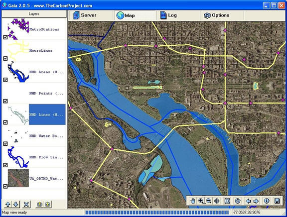
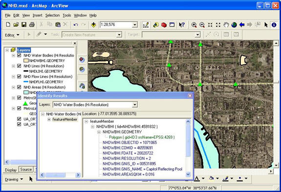
Managed by geoLeaders, the demonstration will highlight multi-vendor interoperability using open-geospatial Web services from CubeWerx, CarbonArc (a new extension for ESRI's ArcGIS developed with CarbonTools) and Gaia, a free open-geospatial .NET viewer from The Carbon Project.In the demonstration, these tools will be used to access a new reference implementation of the National Hydrography Dataset (NHD) through a powerful Web Feature Service (WFS) and a new profile of Geography Markup Language (GML) designed to make it easy to work with sources like NHD.If you are not familiar with the National Hydrography Dataset, it's a national database for US surface waters. With this service, users can access up-to-date hydrographic content and download it directly to their application through an open standards-based service.
Why should you care about an open standards-based Web service? Well, this means users can download data from many different sources, freely exchanging maps and content and rapidly integrating information to support business and personal decision-making.This type of multi-source integration capability is essential to respond to dynamic events like floods and security situations, as well as supporting a wide variety of environmental assessment and planning applications.The demonstration will also show that authorized users can also update the NHD data, ushering in a new age of interactive interoperable geospatial content.
The project has established this reference implementation of the WFS to deliver the NHD as a Framework Data Theme via the Internet using the new GML Simple Features Profile (GMLSF).The Hydrography Framework theme is one of 11 themes coordinated by the FGDC and developed by community content experts to become a draft ANSI Standard for the exchange of basic geographic data.An outcome of this standardization process has been to define GML profiles for the Framework Data Themes of The National Map.The NHD/WFS will serve as an operational reference implementation that can be reused by other organizations at all levels of government.
GMLSF makes it much easier to use GML and WFS in multiple applications, and will translate to lower overall implementation costs and greater flexibility.Potential applications for hydrography data in GMLSF include water quality assessments, natural resource management, environmental site assessments and impact statements, delineating watershed boundaries, among others.Since GMLSF is just XML, it can also be integrated into new applications on network-connected mobile, desktop and multi-media platforms.
When you think about it, the implementation of this and other Category 5 projects is a true milestone in the development of an interoperable NSDI.The use of GMLSF for Framework Data Themes illustrates its ability to help achieve true multi-vendor interoperability for WFS. Likewise, other public and private data sources can also be enabled with GMLSF, which will rapidly lead to a rich set of online content to solve real problems with Web service-based applications.
This project involves the collaboration of multiple partners including CubeWerx, Accelera Solutions and The Carbon Project; as well as the EPA and the USGS.The effort is being funded under a grant from the NSDI Cooperative Agreement Program (CAP) to establish Framework Data Services on interoperable Web Feature Servers.
The NSDI is a coordinated national approach to geospatial data creation, maintenance, and use.It includes a seamless geospatial data framework for the Nation, which is owned by and made available to federal, state and local governments, the private and non-profit sectors, and academia.The data maintained in the NSDI framework can be used to ensure government leaders the ability to make proactive, well planned decisions.
The NSDI CAP was established by the FGDC to help form partnerships to implement the NSDI.The NSDI includes the technology, policies, criteria, standards and people necessary to promote geospatial data sharing throughout all levels of government, the private and non-profit sectors, and academia.As a new approach, this year's CAP is jointly sponsored by the FGDC, Geospatial One-Stop and The National Map - three programs within the USGS National Geospatial Programs Office that share the common goal of building the NSDI.
Send an e-mail for information on attending the upcoming demonstration or to request free Geospatial Session Files (GSFs) from the event.
DISCLAIMER: the information provided in this article does not constitute an endorsement by the EPA, USGS or the FGDC of any non-federal entity, its products or its services.
Throughout 2005, several low-key projects have been quietly deploying NSDI content using next-generation open-geospatial services.On September 22, a preview of this new capability will be rolled out Washington, DC.The demonstration will be conducted at the Federal Geographic Data Committee's (FGDC) Geospatial Applications and Interoperability Working Group Meeting hosted by the U.S.Environmental Protection Agency (EPA) at 1200 Pennsylvania Ave, N.W.
 |
Managed by geoLeaders, the demonstration will highlight multi-vendor interoperability using open-geospatial Web services from CubeWerx, CarbonArc (a new extension for ESRI's ArcGIS developed with CarbonTools) and Gaia, a free open-geospatial .NET viewer from The Carbon Project.In the demonstration, these tools will be used to access a new reference implementation of the National Hydrography Dataset (NHD) through a powerful Web Feature Service (WFS) and a new profile of Geography Markup Language (GML) designed to make it easy to work with sources like NHD.If you are not familiar with the National Hydrography Dataset, it's a national database for US surface waters. With this service, users can access up-to-date hydrographic content and download it directly to their application through an open standards-based service.
Why should you care about an open standards-based Web service? Well, this means users can download data from many different sources, freely exchanging maps and content and rapidly integrating information to support business and personal decision-making.This type of multi-source integration capability is essential to respond to dynamic events like floods and security situations, as well as supporting a wide variety of environmental assessment and planning applications.The demonstration will also show that authorized users can also update the NHD data, ushering in a new age of interactive interoperable geospatial content.
The project has established this reference implementation of the WFS to deliver the NHD as a Framework Data Theme via the Internet using the new GML Simple Features Profile (GMLSF).The Hydrography Framework theme is one of 11 themes coordinated by the FGDC and developed by community content experts to become a draft ANSI Standard for the exchange of basic geographic data.An outcome of this standardization process has been to define GML profiles for the Framework Data Themes of The National Map.The NHD/WFS will serve as an operational reference implementation that can be reused by other organizations at all levels of government.
GMLSF makes it much easier to use GML and WFS in multiple applications, and will translate to lower overall implementation costs and greater flexibility.Potential applications for hydrography data in GMLSF include water quality assessments, natural resource management, environmental site assessments and impact statements, delineating watershed boundaries, among others.Since GMLSF is just XML, it can also be integrated into new applications on network-connected mobile, desktop and multi-media platforms.
When you think about it, the implementation of this and other Category 5 projects is a true milestone in the development of an interoperable NSDI.The use of GMLSF for Framework Data Themes illustrates its ability to help achieve true multi-vendor interoperability for WFS. Likewise, other public and private data sources can also be enabled with GMLSF, which will rapidly lead to a rich set of online content to solve real problems with Web service-based applications.
 |
This project involves the collaboration of multiple partners including CubeWerx, Accelera Solutions and The Carbon Project; as well as the EPA and the USGS.The effort is being funded under a grant from the NSDI Cooperative Agreement Program (CAP) to establish Framework Data Services on interoperable Web Feature Servers.
The NSDI is a coordinated national approach to geospatial data creation, maintenance, and use.It includes a seamless geospatial data framework for the Nation, which is owned by and made available to federal, state and local governments, the private and non-profit sectors, and academia.The data maintained in the NSDI framework can be used to ensure government leaders the ability to make proactive, well planned decisions.
The NSDI CAP was established by the FGDC to help form partnerships to implement the NSDI.The NSDI includes the technology, policies, criteria, standards and people necessary to promote geospatial data sharing throughout all levels of government, the private and non-profit sectors, and academia.As a new approach, this year's CAP is jointly sponsored by the FGDC, Geospatial One-Stop and The National Map - three programs within the USGS National Geospatial Programs Office that share the common goal of building the NSDI.
Send an e-mail for information on attending the upcoming demonstration or to request free Geospatial Session Files (GSFs) from the event.
DISCLAIMER: the information provided in this article does not constitute an endorsement by the EPA, USGS or the FGDC of any non-federal entity, its products or its services.
From Our Homepage
Saying Farewell to an Amazing Journey
Communicating with Maps
Is There a GIS Career Ladder?
What does it mean to be geospatially smart? Series
Ways Real Estate and Property Developers Utilize Melissa GeoData for Data-Driven Decisions
Unlocking Value From Daily Satellite Imagery and Insights
Maximizing the Value of Your Address Data with Geo Addressing
How Indoor Mapping Enhances the Security of Smart Buildings
Look Ahead: AI, Location Intelligence and Efficiency
Collaboration Takes on Sea Level Rise & Dynamic Technology Environments
Brownies for Brownfields
Has Everything Been Mapped Already?
How Is Data Literacy Changing in an Artificial Intelligence Landscape
Portfolios for GIS Professionals: More Than Just Maps
How to Create a Distance Matrix in QGIS - A Step-by-Step Guide
7 Ideas for Bringing GIS into the K-12 Classroom
The Geography of Movement