Vendor
Trimble Navigation Limited
Sunnyvale, CA
Product homepage
Product availability: AllSport GPS Silver through Boost Mobile
Price: $14.95/mo. unlimited use
Introduction
AllSport GPS is a cell phone-based software application, supported by a Web service, for individuals interested in monitoring, recording and mapping their sports activities, such as running, walking, biking, hiking, etc. The application is designed to run on phones supplied by Sprint PCS, Nextel, SouthernLINC, or Boost Mobile (a division of Sprint Nextel). The phone used in this product review, a Motorola i855 from Boost Mobile (Figure 1), was supplied by Trimble Outdoors, a division of Trimble Navigation. The application is first downloaded to the phone and then initialized after the phone acquires the user’s location using the GPS constellation. Information from each session is automatically uploaded to the Web service to which the user logs in to view additional details.
Features and Functions
The basic phone-based functions of the AllSport GPS include keeping time, recording distance and elevation, tabulating calories used and determining average speed. Advanced features include recording lap times, viewing a small map of the completed route and storing daily and weekly statistics. Recording lap times is possible with the "push-to-talk" button for this particular Motorola phone. An audible signal can be engaged to alert the user for each mile or kilometer reached.
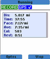
When the workout is completed, a summary is
displayed on the phone of
distance traveled, average speed, calories and rest time, if any
(Figure 2). The user may choose to display a map of the route directly
on the phone. As a GPS application that constantly records elevation in
addition to location, the route profile can be displayed as a
two-dimensional chart of distance versus terrain height above sea
level. A speed chart shows the variation of the user’s speed over
distance. Street maps can be downloaded directly to the phone and the
exact location of the user’s route can be displayed.
AllSport GPS also includes an Internet-based Web service to which the user’s daily workouts are automatically uploaded upon completion of the workout after the user hits the "STOP" button. The service will show the user’s route integrated with Google Maps (or Google Earth) and supports all the features associated with the mapping portal such as the "hybrid" visualization using maps and aerial imagery.
How It Works
After the user initializes the AllSport GPS Java application with a soft key and waits for a GPS signal to be acquired, he or she starts by hitting the "OK" button on the phone. Advanced features such as the audible signals for one mile "split" times can be engaged at this time. The user then straps the phone to an armband holster and the phone automatically begins to record the workout. During the workout, the phone must be taken out of the armband holster to review statistics. When the workout is finished, the user can review statistics, maps and other data recorded by one of the advanced features, such as lap times.
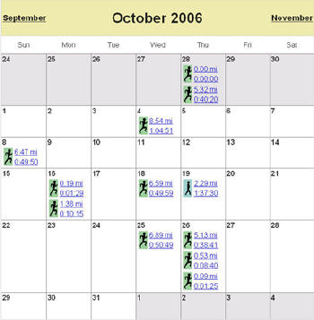
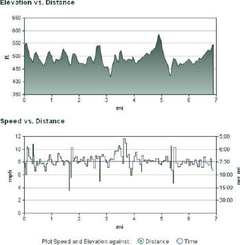
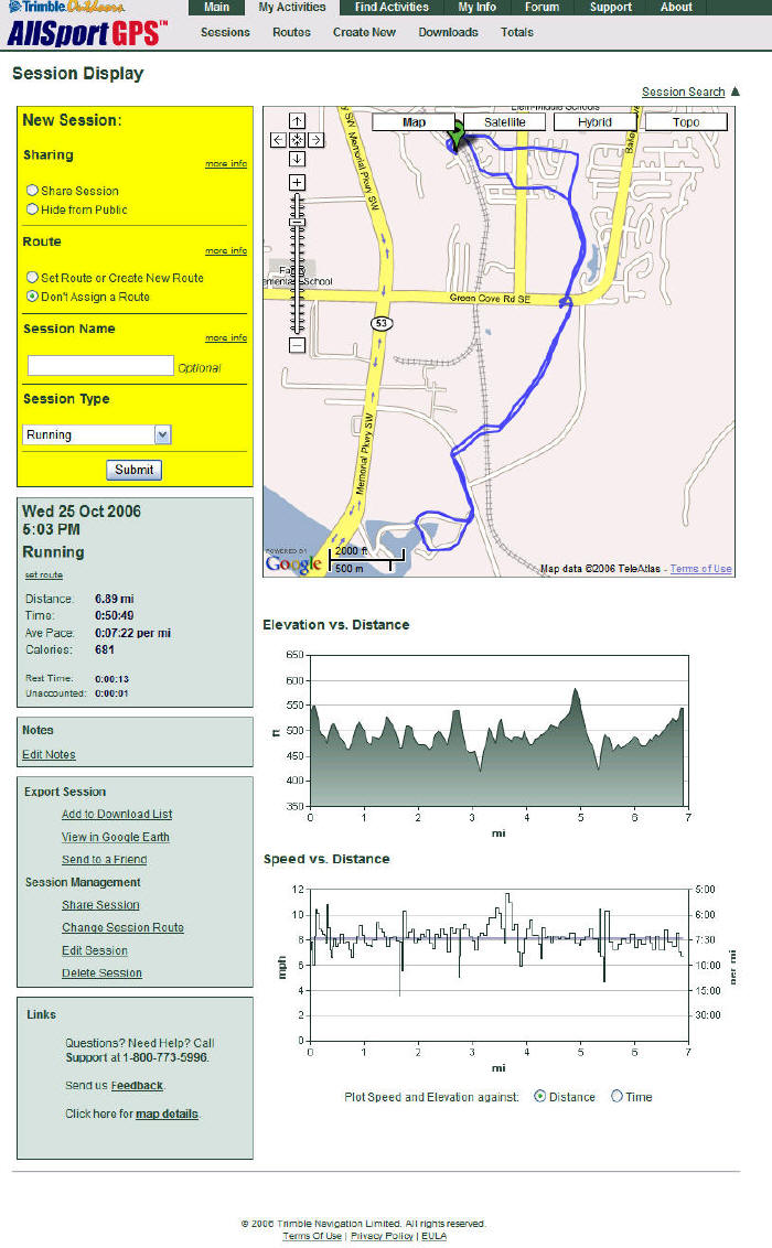
The Web is where the real fun begins. If you are into statistics and keeping a continuous log of your workouts, you’ll appreciate the calendar function (Figure 3) which gives you a quick snapshot of the month’s activities, showing time, distance and the type of workout (running, biking, etc.). A hyperlink for each day offers a complete session history of statistics, maps and the speed and elevation charts (Figure 4). Entire sessions (Figure 5) can be shared with others (coaches, for example) and routes can be named as special "notable" routes or as "frequently used" routes. You can also set up the device to compete against a previously recorded workout.
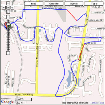
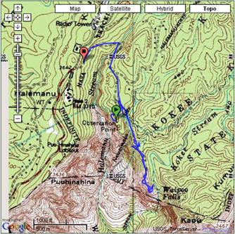
Viewing routes on Google Maps (Figure 6) is helpful but so is the ability to see the routes overlaid onto USGS topographic maps (Figure 7).
How the Product Review Was Conducted
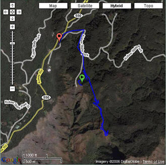
I used the device during normal running workouts around the Huntsville, Alabama area, and in Hawaii during a recent vacation. I also used it on an extensive three-hour hike in Waimea Canyon (Figures 7 and 8) on the island of Kauai. I was pleased at how quickly the device acquired the GPS signals in the urban and suburban areas where I performed my workouts. However, during the hike in a fairly remote area of Kauai, the device seemed to have difficulty acquiring a signal... or so I thought, because I did not immediately see that it had acquired my position before the hike began. But according to the data that were uploaded to the Internet application, the route was entirely captured. I initially thought there was a problem because the phone could not acquire a cell signal independent of the GPS signals. See the explanation of how the phone initializes the application below.
Background on Motorola i855 Phone
Following is some additional information regarding the phone’s acquisition of a GPS signal. According to Trimble, "The phone can acquire GPS without a cell signal -- which is great if you're hiking, etc. in areas outside of cell range. However, it does take longer in this case. If the phone has a cell signal, it receives extra information that helps it get a GPS signal faster, which is a distinct advantage over traditional GPS devices - in particular for mobile phone consumers/users who are used to getting fast data. In order to disable the cell connection, [the user can] hit the hang-up key on the phone and it will stop looking for a cell connection and the Java Platform can be launched. The Java Platform will take 30 seconds to initialize the first time the phone is turned on and then will be instantaneous after that. Once initialized, AllSport GPS can be launched. Also, the cell connection is phone dependant [depending] on if you need the cell connection or not to use the GPS Java app. The phone [Motorola i855] doesn't need it, but Sprint models currently do (although that's changing for some future models)."
How to get the AllSport GPS Application
The AllSport GPS must first be downloaded to a supported phone from the AllSport GPS website. Check with one of the carriers mentioned above to initiate service.
My Take
I really liked the Web-based application that provided the workout summaries uploaded from the device. If you like running, biking or whatever with a phone, this is an all-inclusive and fun application, and I would highly recommend it. But it is a phone, and this model weighed about 5 ounces (not including the armband holster) so it’s not a lightweight device. My Garmin Forerunner 201 (A GPS device with similar functions that straps to your wrist) weighs only 2.5 ounces. Since the AllSport GPS is a holster-supported mobile device, the user must "un-holster" it to read time or distance measurements while the workout is in progress. This is a bit awkward. The holster supplied with the unit "jiggled" a bit and sometimes slid down my arm, so you may want to investigate alternatives that are more comfortable. For example, if you have a shirt pouch or fuel belt, you may want to try to secure the device using one of those. One advantage of the holster is that a Velcro strap wraps over the top of the phone so that it won’t fall out.
With the clamshell design of the phone, the time and distance details can be viewed with the cover closed but the readout is somewhat small. But again, it’s a phone, not a specialized workout device so there will always be pluses and minuses.
If you are an executive on the go and need to be in contact with your office, this is for you. If you appreciate the security of a mobile phone while working out in unknown areas, this is for you. On the down side, don’t expect it to act like a sports watch. It will give you all of the same information and more, but it comes with some extra weight.
The price seems extremely reasonable as an add-on feature. For unlimited use, $14.95 is a good deal, especially considering the features you get on the website. By comparison, the Garmin Forerunner is about $100 and you need to install a program to manually upload your data. Additionally, I found the interface to Google Maps very useful.
Trimble Navigation Limited
Sunnyvale, CA
Product homepage
Product availability: AllSport GPS Silver through Boost Mobile
Price: $14.95/mo. unlimited use
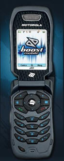 |
AllSport GPS is a cell phone-based software application, supported by a Web service, for individuals interested in monitoring, recording and mapping their sports activities, such as running, walking, biking, hiking, etc. The application is designed to run on phones supplied by Sprint PCS, Nextel, SouthernLINC, or Boost Mobile (a division of Sprint Nextel). The phone used in this product review, a Motorola i855 from Boost Mobile (Figure 1), was supplied by Trimble Outdoors, a division of Trimble Navigation. The application is first downloaded to the phone and then initialized after the phone acquires the user’s location using the GPS constellation. Information from each session is automatically uploaded to the Web service to which the user logs in to view additional details.
Features and Functions
The basic phone-based functions of the AllSport GPS include keeping time, recording distance and elevation, tabulating calories used and determining average speed. Advanced features include recording lap times, viewing a small map of the completed route and storing daily and weekly statistics. Recording lap times is possible with the "push-to-talk" button for this particular Motorola phone. An audible signal can be engaged to alert the user for each mile or kilometer reached.
 |
AllSport GPS also includes an Internet-based Web service to which the user’s daily workouts are automatically uploaded upon completion of the workout after the user hits the "STOP" button. The service will show the user’s route integrated with Google Maps (or Google Earth) and supports all the features associated with the mapping portal such as the "hybrid" visualization using maps and aerial imagery.
How It Works
After the user initializes the AllSport GPS Java application with a soft key and waits for a GPS signal to be acquired, he or she starts by hitting the "OK" button on the phone. Advanced features such as the audible signals for one mile "split" times can be engaged at this time. The user then straps the phone to an armband holster and the phone automatically begins to record the workout. During the workout, the phone must be taken out of the armband holster to review statistics. When the workout is finished, the user can review statistics, maps and other data recorded by one of the advanced features, such as lap times.
The Web is where the real fun begins. If you are into statistics and keeping a continuous log of your workouts, you’ll appreciate the calendar function (Figure 3) which gives you a quick snapshot of the month’s activities, showing time, distance and the type of workout (running, biking, etc.). A hyperlink for each day offers a complete session history of statistics, maps and the speed and elevation charts (Figure 4). Entire sessions (Figure 5) can be shared with others (coaches, for example) and routes can be named as special "notable" routes or as "frequently used" routes. You can also set up the device to compete against a previously recorded workout.
 |
 |
 |
Viewing routes on Google Maps (Figure 6) is helpful but so is the ability to see the routes overlaid onto USGS topographic maps (Figure 7).
 |
 |
How the Product Review Was Conducted
I used the device during normal running workouts around the Huntsville, Alabama area, and in Hawaii during a recent vacation. I also used it on an extensive three-hour hike in Waimea Canyon (Figures 7 and 8) on the island of Kauai. I was pleased at how quickly the device acquired the GPS signals in the urban and suburban areas where I performed my workouts. However, during the hike in a fairly remote area of Kauai, the device seemed to have difficulty acquiring a signal... or so I thought, because I did not immediately see that it had acquired my position before the hike began. But according to the data that were uploaded to the Internet application, the route was entirely captured. I initially thought there was a problem because the phone could not acquire a cell signal independent of the GPS signals. See the explanation of how the phone initializes the application below.
 |
Following is some additional information regarding the phone’s acquisition of a GPS signal. According to Trimble, "The phone can acquire GPS without a cell signal -- which is great if you're hiking, etc. in areas outside of cell range. However, it does take longer in this case. If the phone has a cell signal, it receives extra information that helps it get a GPS signal faster, which is a distinct advantage over traditional GPS devices - in particular for mobile phone consumers/users who are used to getting fast data. In order to disable the cell connection, [the user can] hit the hang-up key on the phone and it will stop looking for a cell connection and the Java Platform can be launched. The Java Platform will take 30 seconds to initialize the first time the phone is turned on and then will be instantaneous after that. Once initialized, AllSport GPS can be launched. Also, the cell connection is phone dependant [depending] on if you need the cell connection or not to use the GPS Java app. The phone [Motorola i855] doesn't need it, but Sprint models currently do (although that's changing for some future models)."
How to get the AllSport GPS Application
The AllSport GPS must first be downloaded to a supported phone from the AllSport GPS website. Check with one of the carriers mentioned above to initiate service.
My Take
I really liked the Web-based application that provided the workout summaries uploaded from the device. If you like running, biking or whatever with a phone, this is an all-inclusive and fun application, and I would highly recommend it. But it is a phone, and this model weighed about 5 ounces (not including the armband holster) so it’s not a lightweight device. My Garmin Forerunner 201 (A GPS device with similar functions that straps to your wrist) weighs only 2.5 ounces. Since the AllSport GPS is a holster-supported mobile device, the user must "un-holster" it to read time or distance measurements while the workout is in progress. This is a bit awkward. The holster supplied with the unit "jiggled" a bit and sometimes slid down my arm, so you may want to investigate alternatives that are more comfortable. For example, if you have a shirt pouch or fuel belt, you may want to try to secure the device using one of those. One advantage of the holster is that a Velcro strap wraps over the top of the phone so that it won’t fall out.
With the clamshell design of the phone, the time and distance details can be viewed with the cover closed but the readout is somewhat small. But again, it’s a phone, not a specialized workout device so there will always be pluses and minuses.
If you are an executive on the go and need to be in contact with your office, this is for you. If you appreciate the security of a mobile phone while working out in unknown areas, this is for you. On the down side, don’t expect it to act like a sports watch. It will give you all of the same information and more, but it comes with some extra weight.
The price seems extremely reasonable as an add-on feature. For unlimited use, $14.95 is a good deal, especially considering the features you get on the website. By comparison, the Garmin Forerunner is about $100 and you need to install a program to manually upload your data. Additionally, I found the interface to Google Maps very useful.
From Our Homepage
Saying Farewell to an Amazing Journey
Communicating with Maps
Is There a GIS Career Ladder?
What does it mean to be geospatially smart? Series
Ways Real Estate and Property Developers Utilize Melissa GeoData for Data-Driven Decisions
Unlocking Value From Daily Satellite Imagery and Insights
Maximizing the Value of Your Address Data with Geo Addressing
How Indoor Mapping Enhances the Security of Smart Buildings
Look Ahead: AI, Location Intelligence and Efficiency
Collaboration Takes on Sea Level Rise & Dynamic Technology Environments
Brownies for Brownfields
Has Everything Been Mapped Already?
How Is Data Literacy Changing in an Artificial Intelligence Landscape
Portfolios for GIS Professionals: More Than Just Maps
How to Create a Distance Matrix in QGIS - A Step-by-Step Guide
7 Ideas for Bringing GIS into the K-12 Classroom
The Geography of Movement