The conventional use of demographics by market researchers involved with site selection is cumbersome, and typically involves the generation of maps and reports based on proximity to a proposed location. Traditional demographic data provide individual counts and tabulations for each specific unit of geography (see Figure 1). Often researchers are interested in identifying areas where certain thresholds of population, income, or other demographics within a specific proximity are present. For example many franchises require a certain level of population before they consider opening a branch in a particular area. This effort commonly uses GIS or related mapping technology to display the demographic data and to generate summaries or reports based on the proximity measures and demographics of interest. This is often a hit-or-miss exercise that is time consuming and subject to potential errors and inaccuracies.
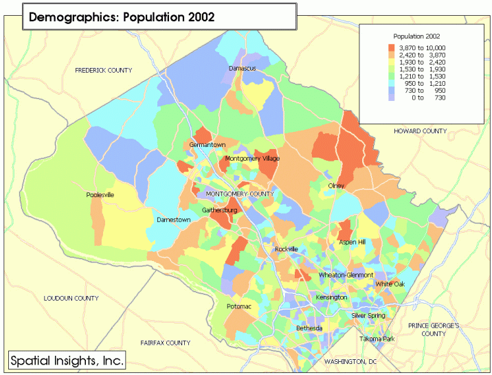
Figure 1. Traditional thematic map showing the distribution
of population by block group in Montgomery County, MD.
(Click on Map for larger view)
Additionally, the traditional approach does not allow the analyst to readily visualize or identify where specific areas are located that have the desired thresholds of demographic characteristic without interactive evaluation on a site-by-site basis.
Demographic data that are generated based on cumulative tabulations
summarized within a specified proximity provide an innovative new alternative
to the use of demographics for site selection and market potential studies.
By facilitating the visualization and analysis of prospective sites using
geographic access criteria, better decisions can be made more efficiently.

Figure 2. Thematic map showing the distribution of population
by block group, based on proximity within a 5-mile radius.
(Click on Map for larger view)
Spatial Insights, Inc.has pioneered the development of "ProximityDemographics", an innovative compilation of demographics based on radial proximity or drive time distance.
ProximityDemographics provide a measure of cumulative demographic data within a specified radius or drive time of each geography. Thus, a market researcher can quickly identify areas that have required levels of cumulative demographic characteristics without any additional analysis. Knowing a location's access to a particular type of population is ideal for retailers or service establishments whose business depends upon their access to customers.
Methodology:
ProximityDemographics are derived using proprietary spatial analysis
technologies. The data are accumulated upwards from block-level base
demographics, and are available summarized by block group, census tract,
and ZIP code. Standard summarizations can be based on radii or drive
times calculated from the center of each geography. The choice between
radius circles and drive time polygons is determined by the nature of the
business. Similarly, demands of the particular business dictate the
diameter of the radii or the drive time distance used.
The accumulated proximity-based tabulations are then associated with
the origin centroid and boundary or the geographic unit.
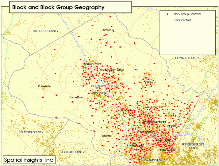
Figure 3. Map showing the distribution of block and block group
centroids. (Click on Map for larger view)
Figure 4.Map showing the distribution of 5-mile radii around
each block group. (Click on Map for larger view)
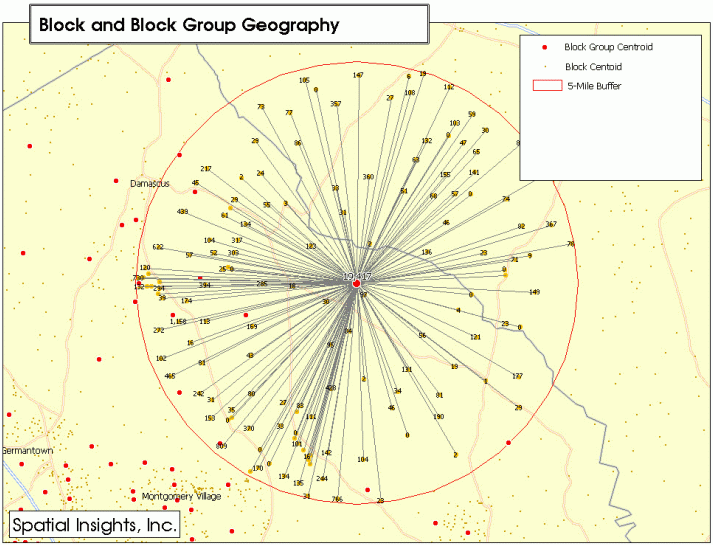
Figure 5. Map of the northeastern portion of the county showing
the summarization of block level demographics within a 5-mile radius of
the block group centroid. (Click on Map for larger
view)
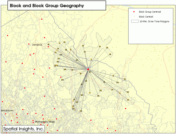
Figure 6. Map of the northeastern portion of the county showing
the summarization of block level demographics within a 10-minute drive
time of the block group centroid. (Click on Map
for larger view)
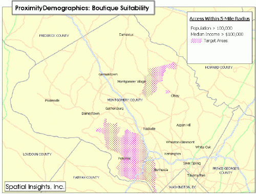
Case Study Example:
In the case study below, a boutique retailer was interested in identifying
areas within Montgomery County, MD that would be suitable for placement
of a new store. Montgomery County, MD is an affluent suburb adjacent
to Washington, DC. Market research based on performance data from
stores in other markets indicated that their most successful stores were
located in areas where there were more than 100,000 people with incomes
averaging over $100,000/yr within a 5-mile radius. Initially, standard
block group thematic maps were generated showing the distribution of population
and income - the two key demographic criteria underlying the site selection
process.

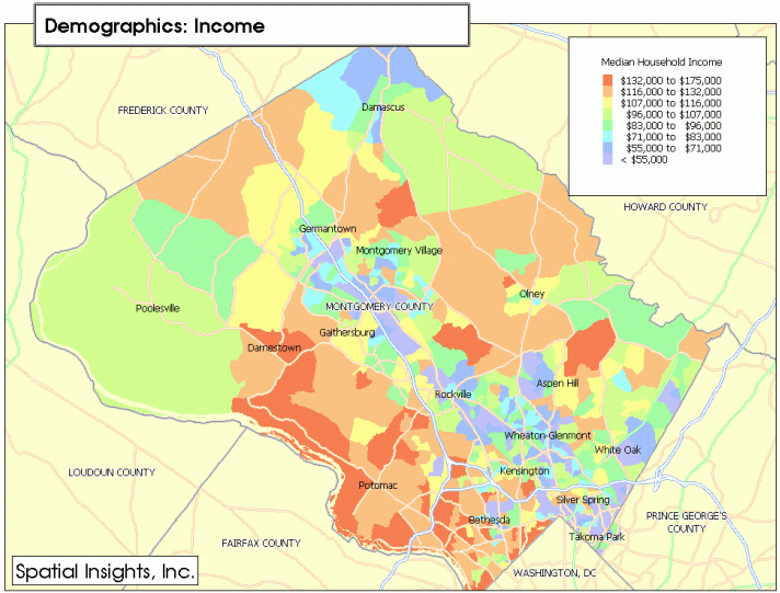
Although these conventional thematic maps are informative, they only illustrate the demographic characteristics at individual locations (block groups), and do not provide any direct indication of the cumulative effects of adjacency or proximity. Using these conventional thematic displays, individual locations could only be evaluated by iterative analysis and report generation, which required considerable time and expertise.
ProximityDemographics for population and median income were generated
for the area based on a 5-mile radius. (Click on
Map for larger view)
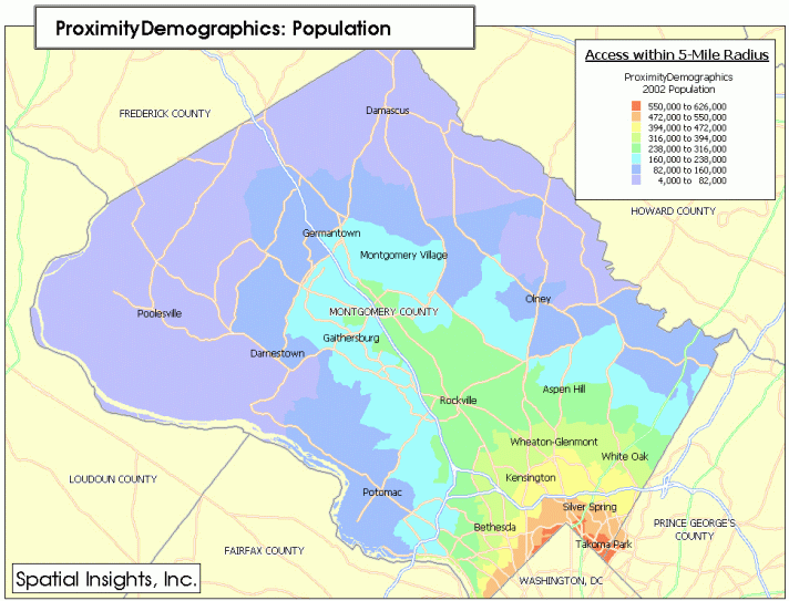
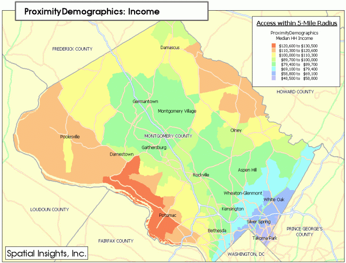
The ProximityDemographic thematic maps clearly delineate the distribution
of access to population and income, by incorporating the important concept
of proximity into account. (Click on Map for
larger view)
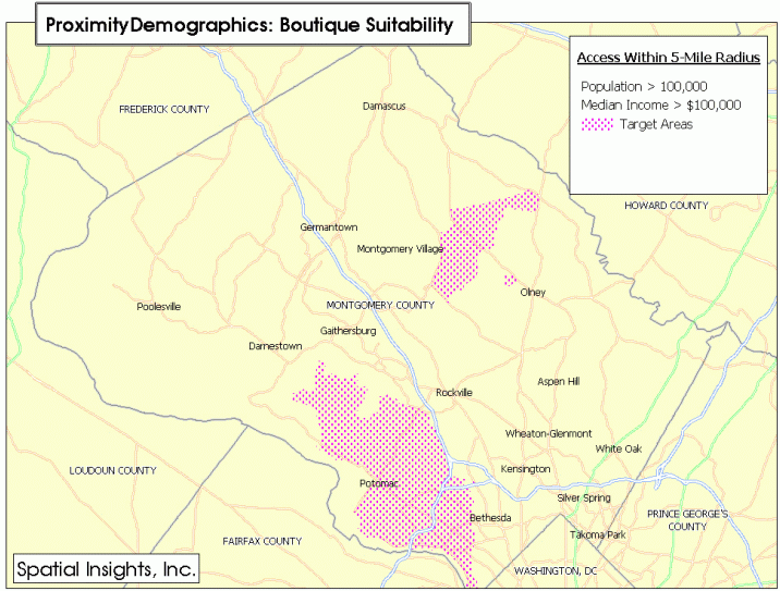
A simple query was performed that identified the ProximityDemographic-derived
block groups with population greater than 100,000 people and incomes averaging
over $100,000/yr within a 5-mile radius. The resulting map clearly
shows where candidate pockets of the target demographic are located.
Notably, only 11% of the entire county fell within the threshold of the
target demographic.Analysis of competitive locations and subsequent field
research costs were greatly reduced by eliminating almost 90% of the county
from consideration.
 About Spatial Insights, Inc.
Spatial Insights, Inc.is a geographic information services company
specializing in providing innovative project consulting and mapping services,
customized software solutions and data products to commercial organizations.
Spatial Insights, Inc.is based in Falls Church, VA and is privately held.
Additional information about Spatial Insights products and services are
available at www.spatialinsights.com.