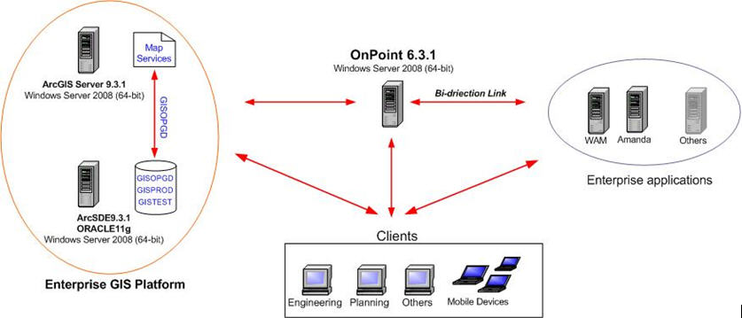
The city of Guelph, Ontario has reengineered its enterprise GIS model, successfully implementing ESRI's most current version of the ArcGIS Server, version 9.3.1. It includes ArcSDE and ArcGIS Server as the platform for data maintenance, exchange, update and data sharing across the entire city (Figure 1). Taking advantage of the new ArcGIS Server environment, Orion's (a Rolta company) OnPoint 6.3.1 was installed and configured to provide citywide users with robust and user-friendly, Web-based GIS applications.
 |
Configuring the Enterprise GIS Platform
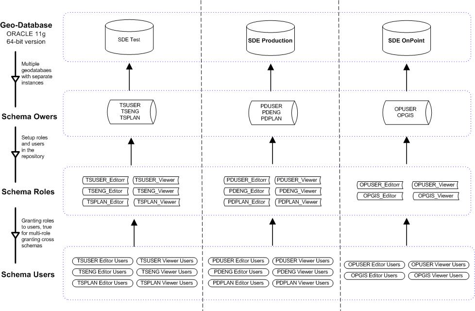
The ArcSDE 9.3.1 64-bit edition was installed on top of the Oracle 11g 64-bit edition on a Windows Server 2008 (64-bit) box. It was configured as multiple geodatabases with separate Oracle instances and multiple user groups with different privileges (Figure 2). This configuration made it possible to set up a version editing environment on the new ArcSDE services for the engineering and planning user groups and other ArcEditor users. This allows them to maintain the data for which they are responsible, and at the same time share them with the other user groups that have been granted privileges.
With this configuration, the data maintenance is no longer in shapefile format, the data update delay is minimized, and the city's business workflow has improved dramatically.
This implementation also made it possible for the city's Web-based GIS application (OnPoint) to have its dedicated ArcSDE service (SDE OnPoint), which ensures less down time. ArcGIS Server 9.3.1 was installed and configured on a separate Windows Server 2008 (64-bit) box as a 32-bit application. Any map services for city business can be published on the GIS Server. This way, the city's spatial datasets can be shared throughout Internet and consumed by any client site application and device.
 |
Building a Web GIS Application: OnPoint 6.3.1
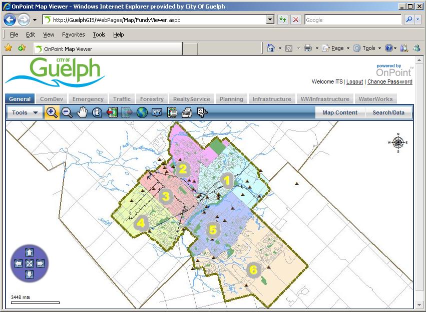
OnPoint 6.3.1 was installed and configured on another Windows Server 2008 (64-bit) box, making GIS available to as many staff members as possible across the entire city. They can dynamically access the up-to-date mapping information, including aerial maps, and the joined information from various business unit databases.
The OnPoint configuration included 10 map tabs for different city businesses, multi-level joins to the attribute database with GIS layers, location search tools, buffer selection, reports and notifications, mailing labels and role-based authentication membership security. Taking advantage of all the functionalities in OnPoint allows city staff to use spatial analysis and visualization as part of everyday decision making to work smarter and more efficiently and increase productivity.
 |
Integrating with Other Enterprise Applications: Bidirectional Links
The next solution required was a bidirectional link between Oracle's Work and Asset Management (WAM) and the city's internal Web-based GIS application – OnPoint. This bidirectional link solution replaced an earlier vendor supported solution with limited functionality, thus solving a long-standing problem for the city and saving the city a maintenance cost of up to $10 thousand yearly. With this bidirectional link, all authorized users can easily switch between the maps in OnPoint and the detailed asset records in WAM to view up-to-date information for the asset layers (for example, water and sewer, sanitation, street signs and city trees). It also gives users the capability to access work orders, customer service requests and asset groups, allowing quicker response to customer requests and issues.
The next step for the OnPoint and WAM bidirectional link was to solve the redundant data entry and synchronization problems to make sure that every record had a valid link between OnPoint and WAM.
The bidirectional link reduced annual operating costs and improved city services. City staff members have already seen the benefit of integrating spatial data with WAM. These improvements encourage officials to keep looking at other enterprise systems such as Amanda, to help improve decision making processes. They have already purchased Amanda GIS Adaptor from CSDC and will start to work on the bidirectional link for OnPoint-Amanda in the near future.
Conclusion
Overall, the redesigned enterprise GIS model and the most current version of the GIS applications leverage the newest technologies, enabling city staff to take full advantage of the new enhancements, functionality and features of the technology to streamline their workflows in day-to-day jobs. Moreover, the 64-bit servers maximize the performance of all the GIS applications.
Ed. note: The authors requested that figures 2 and 3 be updated after this article was originally published. The updated figures reflect updates in database names and an updated URL.