In October 2004, Kevin Coleman discussed the susceptibility
of the U.S. food supply chain to bioterrorist attack. Given events
surrounding the recent E. coli outbreak in spinach grown in the U.S.,
now is an ideal time to revisit the subject of food safety by expanding
upon the place of agriculture in the United States and some of the ways
in which geospatial technology, and its practitioners, can address this
area of homeland security.
The vital roles played by agriculture (and those employed in that sector of our economy) are largely underappreciated by many people. These roles include the provision of food, maintenance of healthy ecosystem function, and enhancement of aesthetic qualities. However, the "selling point" most often used to convey the importance of agriculture, and to capture the attention of decision makers, is simple economics. Various reports published by the U.S. Department of Agriculture’s (USDA) Economic Research Service (ERS) show that agriculture is a multi-billion dollar industry, with the total value of agricultural products exceeding $117 billion dollars, and that of agriculture and related industries topping $563 billion.
While many of the plant and animal products grown or raised in the U.S. are used domestically, a significant portion is also exported to other nations. In 2004, total U.S. agricultural exports were estimated at $61.4 billion - with agriculture being one of the few trade sectors in which the U.S. often exports a higher value commodity than we import. While these national figures are certainly impressive, the economics of agriculture is perhaps even more important at the state and county scales. Consider, for instance, that farm income accounts for over 30% of the total income in many rural U.S. counties.
So, the "grand challenge" for domestic food safety and security programs is then twofold: To ensure access to a safe, reliable and inexpensive food supply and, at the same time, to maintain the profitability of plant and animal production systems. However, our collective ability to meet this challenge is under constant threat.
We face, for example, the nearly impossible task of stopping invasive pests and introduced pathogens from entering the country. Unfortunately, the number of such introductions will not only continue, but likely increase, if for no other reason than sheer logistics. In fiscal year (FY) 2005, the U.S. imported nearly 27 million metric tons of agricultural products (excluding wine and malt beverages). Of this amount, significantly less than 5% was subjected to thorough inspection. Despite this low inspection rate, the Department of Homeland Security’s Customs and Border Protection agency seized a daily average of over 1,100 prohibited agricultural products at ports of entry in FY 2005, including 147 agricultural pests.
The financial impact of disease and pest management is significant, costing the agricultural industry in the neighborhood of $3 billion per year. The projected economic impact of one disease alone, Asian soybean rust (first introduced into the U.S. in 2004), is upwards of $2 billion. This, and future introductions may result in restrictions on domestic and foreign trade, disruptions in food production, changes in consumer perceptions and confidence, and employment declines within all aspects of agriculture and food markets.
Given the monetary importance of the agricultural sector, it is not an overstatement to say that the economic well-being of the nation, and that of many rural communities, is susceptible to significant disruption. Several additional factors further expose U.S. agriculture to the harm posed by natural and intentional introductions of pests and pathogens. These "multiplying" factors include a genetic simplification of planted landscapes and food animal lines that makes crops and livestock more susceptible to disease, the difficulty of monitoring plant and animal conditions (i.e., situational awareness) over large geographic areas, and the concentrations of crops and livestock production at local and regional scales.
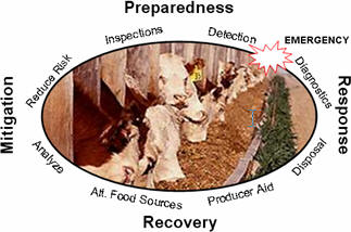
One framework which can be used to plan for and execute our response to agricultural biosecurity events is the emergency response cycle outlined by hazards researchers. Here the term "hazard" is considered broadly, and can be applied equally to natural events, technological failures and biological agents. The cycle of emergency response begins with "preparedness" - how people and places plan to deal with a hazard event. Eventually, a disaster happens (such as a tornado) and it tests how well we have prepared for that hazard. We respond to the emergency by rescuing people and addressing other immediate threats to life, limb and property. Following response is the recovery stage, which includes "cleaning up" after the disaster and other efforts geared toward getting back to "normal" conditions. Next, and often concurrent with the later recovery activities, is the mitigation phase. Here, the disaster and our reaction to it are assessed, and ways to improve preparedness, response and recovery are identified. Finally we transition back to the preparedness stage, await the next hazard and begin the whole process again.
This same emergency response cycle can be used to guide our actions in the event of a biological hazard and, I believe, contribute to an operational definition of food safety and agricultural biosecurity:
Consider for a moment a scenario where Foot and Mouth Disease (FMD) is detected in beef cattle within a commercial feedlot. After confirming the diagnosis, the relevant state department of agriculture working in conjunction with the USDA will implement some form of an animal carcass disposal plan. That plan will involve destroying cattle from the affected feedlot, as well as those from neighboring operations within an established quarantine zone, to prevent the spread of the disease. For some states, such as Kansas, the preferred disposal mechanism is burial. The next logical question to ask, then, is where to bury as many as several hundred thousand head of cattle found within the quarantine zone?
To help solve this problem, we can view and simultaneously analyze a series of thematic data layers in a GIS-based landscape suitability model to prepare our emergency response. Geographical datasets including environmental and cultural information related to soils, geology, water resources, transportation networks, threatened and endangered species, and population can be combined into automated digital workflows using functionality built into commercial GIS software packages. The model created for the State of Kansas currently uses twelve data layers that represent "exclusion criteria" developed by the Kansas Department of Health and Environment (KDHE). These data are then subjected to various geoprocessing procedures to produce maps that identify the cumulative geographic area falling within the spatial extent of one or more of the predefined exclusion criteria - in other words, the least preferred sites for carcass burial.
Running this model yields results such as that shown here for Finney County, Kansas. Green areas on the map represent locations that do not violate any exclusion criteria and, therefore, would be preferred burial sites. Based upon the KDHE exclusion criteria, nearly 40% of the county would be unsuitable for animal burial. It is important to note that licensed animal feeding operations are required by the state to develop a plan for onsite livestock burial. However, a visual comparison between actual feedyard locations (not shown on map for security reasons) and preferred mass burial locations indicates a potential flaw in this strategy - and that onsite burial may not actually be in the long term interests of regional populations.
Given the automated nature of this method, emergency managers now have a sound procedure, based upon good science, for rapidly identifying suitable burial sites before and during an event. The ability to "pre-emptively" target preferred sites for burial is especially helpful when negotations are required to obtain burial rights on private lands.
After the September 11, 2001 terrorist attacks, several post-event analyses have highlighted the importance of both GIS and geographic data in providing rapid and effective emergency response. Summarized from Galloway (2003), some of those key findings include:
References:
Cutter, S.L. 2003. GI Science, disasters, and emergency management. Transactions in GIS 7(4):439-445.
Galloway, G.E. 2003. Emergency preparedness and response: Lessons learned from 9/11. In Cutter, S.L., Richardson, D.B., and Wilbanks, T.J. (eds) Geographical Dimensions of Terrorism. New York, Routledge: 27-34.
Thomas, D.S.K., S.L. Cutter, M. Hodgson, M. Gutekunst, and S. Jones. 2002. Use of Spatial Data and Geographic Technologies in Response to the September 11 Terrorist Attack. Boulder, CO, University of Colorado, Natural Hazards Research and Applications Information Center, Quick Response Bulletin No. 153 (available at ).
The vital roles played by agriculture (and those employed in that sector of our economy) are largely underappreciated by many people. These roles include the provision of food, maintenance of healthy ecosystem function, and enhancement of aesthetic qualities. However, the "selling point" most often used to convey the importance of agriculture, and to capture the attention of decision makers, is simple economics. Various reports published by the U.S. Department of Agriculture’s (USDA) Economic Research Service (ERS) show that agriculture is a multi-billion dollar industry, with the total value of agricultural products exceeding $117 billion dollars, and that of agriculture and related industries topping $563 billion.
While many of the plant and animal products grown or raised in the U.S. are used domestically, a significant portion is also exported to other nations. In 2004, total U.S. agricultural exports were estimated at $61.4 billion - with agriculture being one of the few trade sectors in which the U.S. often exports a higher value commodity than we import. While these national figures are certainly impressive, the economics of agriculture is perhaps even more important at the state and county scales. Consider, for instance, that farm income accounts for over 30% of the total income in many rural U.S. counties.
So, the "grand challenge" for domestic food safety and security programs is then twofold: To ensure access to a safe, reliable and inexpensive food supply and, at the same time, to maintain the profitability of plant and animal production systems. However, our collective ability to meet this challenge is under constant threat.
We face, for example, the nearly impossible task of stopping invasive pests and introduced pathogens from entering the country. Unfortunately, the number of such introductions will not only continue, but likely increase, if for no other reason than sheer logistics. In fiscal year (FY) 2005, the U.S. imported nearly 27 million metric tons of agricultural products (excluding wine and malt beverages). Of this amount, significantly less than 5% was subjected to thorough inspection. Despite this low inspection rate, the Department of Homeland Security’s Customs and Border Protection agency seized a daily average of over 1,100 prohibited agricultural products at ports of entry in FY 2005, including 147 agricultural pests.
The financial impact of disease and pest management is significant, costing the agricultural industry in the neighborhood of $3 billion per year. The projected economic impact of one disease alone, Asian soybean rust (first introduced into the U.S. in 2004), is upwards of $2 billion. This, and future introductions may result in restrictions on domestic and foreign trade, disruptions in food production, changes in consumer perceptions and confidence, and employment declines within all aspects of agriculture and food markets.
Given the monetary importance of the agricultural sector, it is not an overstatement to say that the economic well-being of the nation, and that of many rural communities, is susceptible to significant disruption. Several additional factors further expose U.S. agriculture to the harm posed by natural and intentional introductions of pests and pathogens. These "multiplying" factors include a genetic simplification of planted landscapes and food animal lines that makes crops and livestock more susceptible to disease, the difficulty of monitoring plant and animal conditions (i.e., situational awareness) over large geographic areas, and the concentrations of crops and livestock production at local and regional scales.
One framework which can be used to plan for and execute our response to agricultural biosecurity events is the emergency response cycle outlined by hazards researchers. Here the term "hazard" is considered broadly, and can be applied equally to natural events, technological failures and biological agents. The cycle of emergency response begins with "preparedness" - how people and places plan to deal with a hazard event. Eventually, a disaster happens (such as a tornado) and it tests how well we have prepared for that hazard. We respond to the emergency by rescuing people and addressing other immediate threats to life, limb and property. Following response is the recovery stage, which includes "cleaning up" after the disaster and other efforts geared toward getting back to "normal" conditions. Next, and often concurrent with the later recovery activities, is the mitigation phase. Here, the disaster and our reaction to it are assessed, and ways to improve preparedness, response and recovery are identified. Finally we transition back to the preparedness stage, await the next hazard and begin the whole process again.
 |
This same emergency response cycle can be used to guide our actions in the event of a biological hazard and, I believe, contribute to an operational definition of food safety and agricultural biosecurity:
"The ability to develop, maintain, and execute a rapid and effective emergency response to disease outbreaks and invasive species in order to ensure a safe, constant, and profitable supply of food, feed, and fiber." (Author's unpublished quote)Geospatial technologies have played, and will continue to play, a key role in the development, maintenance and execution of emergency response cycles related to food security and agricultural biosecurity events. One example that illustrates this role is a spatial model for locating large-scale livestock carcass disposal sites.
Consider for a moment a scenario where Foot and Mouth Disease (FMD) is detected in beef cattle within a commercial feedlot. After confirming the diagnosis, the relevant state department of agriculture working in conjunction with the USDA will implement some form of an animal carcass disposal plan. That plan will involve destroying cattle from the affected feedlot, as well as those from neighboring operations within an established quarantine zone, to prevent the spread of the disease. For some states, such as Kansas, the preferred disposal mechanism is burial. The next logical question to ask, then, is where to bury as many as several hundred thousand head of cattle found within the quarantine zone?
To help solve this problem, we can view and simultaneously analyze a series of thematic data layers in a GIS-based landscape suitability model to prepare our emergency response. Geographical datasets including environmental and cultural information related to soils, geology, water resources, transportation networks, threatened and endangered species, and population can be combined into automated digital workflows using functionality built into commercial GIS software packages. The model created for the State of Kansas currently uses twelve data layers that represent "exclusion criteria" developed by the Kansas Department of Health and Environment (KDHE). These data are then subjected to various geoprocessing procedures to produce maps that identify the cumulative geographic area falling within the spatial extent of one or more of the predefined exclusion criteria - in other words, the least preferred sites for carcass burial.
Running this model yields results such as that shown here for Finney County, Kansas. Green areas on the map represent locations that do not violate any exclusion criteria and, therefore, would be preferred burial sites. Based upon the KDHE exclusion criteria, nearly 40% of the county would be unsuitable for animal burial. It is important to note that licensed animal feeding operations are required by the state to develop a plan for onsite livestock burial. However, a visual comparison between actual feedyard locations (not shown on map for security reasons) and preferred mass burial locations indicates a potential flaw in this strategy - and that onsite burial may not actually be in the long term interests of regional populations.
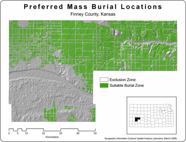 |
Given the automated nature of this method, emergency managers now have a sound procedure, based upon good science, for rapidly identifying suitable burial sites before and during an event. The ability to "pre-emptively" target preferred sites for burial is especially helpful when negotations are required to obtain burial rights on private lands.
After the September 11, 2001 terrorist attacks, several post-event analyses have highlighted the importance of both GIS and geographic data in providing rapid and effective emergency response. Summarized from Galloway (2003), some of those key findings include:
- Having geographic datasets for critical infrastructure already developed and on-hand prior to an emergency
- Having the human and information technology infrastructure in place to facilitate sharing geographic information
- The importance of graphical forms of communication, such as maps, in conveying information to both decision makers and the public
- Having made a "pre-response" investment in developing relevant decision support tools
References:
Cutter, S.L. 2003. GI Science, disasters, and emergency management. Transactions in GIS 7(4):439-445.
Galloway, G.E. 2003. Emergency preparedness and response: Lessons learned from 9/11. In Cutter, S.L., Richardson, D.B., and Wilbanks, T.J. (eds) Geographical Dimensions of Terrorism. New York, Routledge: 27-34.
Thomas, D.S.K., S.L. Cutter, M. Hodgson, M. Gutekunst, and S. Jones. 2002. Use of Spatial Data and Geographic Technologies in Response to the September 11 Terrorist Attack. Boulder, CO, University of Colorado, Natural Hazards Research and Applications Information Center, Quick Response Bulletin No. 153 (available at ).
From Our Homepage
Saying Farewell to an Amazing Journey
Communicating with Maps
Is There a GIS Career Ladder?
What does it mean to be geospatially smart? Series
Ways Real Estate and Property Developers Utilize Melissa GeoData for Data-Driven Decisions
Unlocking Value From Daily Satellite Imagery and Insights
Maximizing the Value of Your Address Data with Geo Addressing
How Indoor Mapping Enhances the Security of Smart Buildings
Look Ahead: AI, Location Intelligence and Efficiency
Collaboration Takes on Sea Level Rise & Dynamic Technology Environments
Brownies for Brownfields
Has Everything Been Mapped Already?
How Is Data Literacy Changing in an Artificial Intelligence Landscape
Portfolios for GIS Professionals: More Than Just Maps
How to Create a Distance Matrix in QGIS - A Step-by-Step Guide
7 Ideas for Bringing GIS into the K-12 Classroom
The Geography of Movement