One can question how many 3D Internet globe products
the world needs. The answer will be determined by the marketplace; I
expect some thinning out of the players in perhaps the next three years
or so. But for now, new players are still entering the market and
introducing their business models. The latest entry from Skyline
Software of Chantilly, Virginia is SkylineGlobe.com.
Skyline offers a free 3D visualization platform for end users, as well as developer tools, all of which access detailed data from GlobeXplorer and i-cubed. Several data providers will also offer 3D models, including David Colleen's Planet 9. That means users will find very high resolution imagery and, for several cities, fully rendered 3D buildings. Developers need to be aware of two important characteristics that distinguish Skyline's product from the offerings of other 3D globe products: Skyline offers a free API to build globe applications based on the technology and the ability to overlay imagery (still or video) in real time over the terrain.
Developers First
Skyline's first order of business with the recent SkylineGlobe.com launch is to engage the developer community. For that reason, the developer part of the site is now available, while the free consumer version will be launched in a few months. Note that this order is a bit different than other players in the space; most platforms launch a consumer version first and the developer model afterward.
Developers have three choices in how they partner with Skyline to use SkylineGlobe.com. At the high end are the SkylineGlobe Business Packages which, for an annual fee, allow an organization to host its own implementation, with its own logo and content. The application still taps into Skyline's huge database of content. That package runs $20,000 for commercial businesses and $5,000 for local governments. The purpose is to allow hosting organizations to drive traffic to their sites or better serve their constituencies.
However, the vast majority of interest, some 80%, is the in the free SkylineGlobe API. Those developers build their own tools and upload them to SkylineGlobe.com for any user to access. Why put your tool there? "To let the public know what you can do and to drive business to your company," explains Rony Ledany, Business Development Director for Skyline.
Another class of developers, those interested in embedding Skyline's tools in their own solutions, can choose the Integrator Package, which runs $30,000 per year. With it, developers can license the technology to provide, for example, 3D streaming in video games, desktop GIS or other tools that have Internet access. At this point the company counts half a dozen developers in its "for fee" programs in areas such as real estate, GPS and Web cam apps.
End Users Second
The end user site has not been publicly launched, as I noted, but I got a sneak preview. A free downloadable 5Mb browser plug-in is required to access SkylineGlobe.com. That's important; this is not a desktop app like Google Earth, but a plug-in. There's also a professional version, SkylineGlobe Pro, that allows not just viewing, but the ability to author 3D environments and to collaborate. It runs $500/year.
I'm someone who's not 100% comfortable in 3D. I get motion sickness at the drop of a hat in 3D movies and the like, and have always had trouble with my 3D flying technique on a computer. So, I was surprised at how comfortable I was with the SkylineGlobe.com interface. You move around, that is "fly," by holding down the mouse and pointing it in the direction of interest. Large green arrows at the edges of the map window adjust the angle from overhead (ortho) to oblique. A numbered scale tool zooms from 10 (earth) to 1 (house).
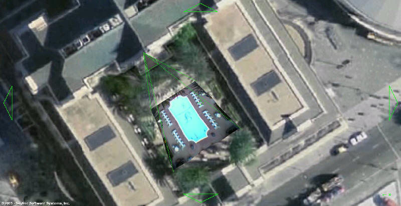
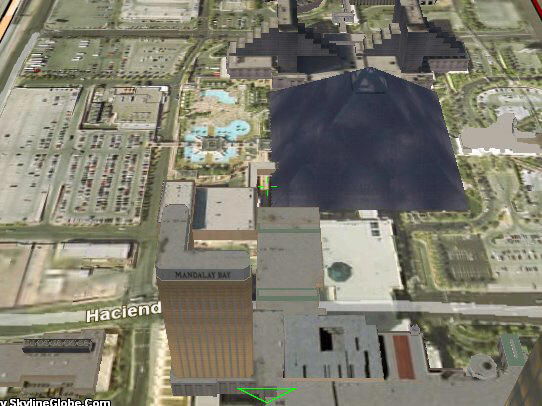
A pane at the left holds the data layers and tools. Skyline offers basic imagery, roads, census data, populated places and the like, along with a "customer showcase" where other interesting data layers selected by the Skyline team are shared. The demo I saw showed Planet 9 buildings populating the Las Vegas strip.
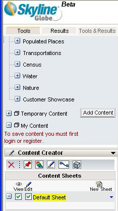
There's also a folder for "my content" where users can save areas of interest and layers of data on their own machines. Either of those requires a free registration with Skyline. The data are held locally, on your machine, and are accessed via a cookie.
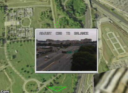
While the data are very nice, the tools are the stars of the show at SkylineGlobe.com. There's a data creator for scribbling or marking points of interest. (With the Pro version you can annotate the SkylineGlobe terrain model: create, import, manipulate and edit new and existing objects.) There are traffic cams. Click on one in the list in the Tools pane and you fly to its location and see near real time images of traffic. In the demo, traffic cams are available from several dozen spots in Washington DC. Twenty-one more cities are promised from partner TrafficLand.com. CustomWeather provides its weather information, updated every three minutes. (If you care to look under the hood, you’ll find that the CustomWeather data come in via a Web Map Server, WMS; the base road data, via a streaming Web Feature Service, WFS.) A travel planner tool allows searching for hotels – along with booking right from the application. The Guided Tour tool is perhaps the most unique. After signing in, one user may "drive the screen" of a second user, taking them on a tour.
The "interactive Visual Search" vision, noted above, is still here. Across the top of the app are query tools for addresses, driving directions and businesses. As consumers now expect, once a destination is found, it's possible to get more information, or to get directions to or from the location. The points of interest database and the geocoding are from partner MapQuest.
My Take
Skyline is "closer" to the GIS marketplace than Google Earth at this point, due to its support for an extensive list of GIS data/database formats (Oracle Spatial, ArcSDE, .kml, shp, dxf, geotiff, ECW, MrSID, GPS) and OGC specifications (WMS, WFS). It's also got a leg up with professionally created 3D buildings and the ability to create and add your own. Developers will need to evaluate the free API to explore its ease of use and power. Once the free SkylineGlobe.com browser plug-in is available, it will certainly be worth a look by the GIS community.
Skyline offers a free 3D visualization platform for end users, as well as developer tools, all of which access detailed data from GlobeXplorer and i-cubed. Several data providers will also offer 3D models, including David Colleen's Planet 9. That means users will find very high resolution imagery and, for several cities, fully rendered 3D buildings. Developers need to be aware of two important characteristics that distinguish Skyline's product from the offerings of other 3D globe products: Skyline offers a free API to build globe applications based on the technology and the ability to overlay imagery (still or video) in real time over the terrain.
 |
Developers First
Skyline's first order of business with the recent SkylineGlobe.com launch is to engage the developer community. For that reason, the developer part of the site is now available, while the free consumer version will be launched in a few months. Note that this order is a bit different than other players in the space; most platforms launch a consumer version first and the developer model afterward.
Developers have three choices in how they partner with Skyline to use SkylineGlobe.com. At the high end are the SkylineGlobe Business Packages which, for an annual fee, allow an organization to host its own implementation, with its own logo and content. The application still taps into Skyline's huge database of content. That package runs $20,000 for commercial businesses and $5,000 for local governments. The purpose is to allow hosting organizations to drive traffic to their sites or better serve their constituencies.
However, the vast majority of interest, some 80%, is the in the free SkylineGlobe API. Those developers build their own tools and upload them to SkylineGlobe.com for any user to access. Why put your tool there? "To let the public know what you can do and to drive business to your company," explains Rony Ledany, Business Development Director for Skyline.
Another class of developers, those interested in embedding Skyline's tools in their own solutions, can choose the Integrator Package, which runs $30,000 per year. With it, developers can license the technology to provide, for example, 3D streaming in video games, desktop GIS or other tools that have Internet access. At this point the company counts half a dozen developers in its "for fee" programs in areas such as real estate, GPS and Web cam apps.
End Users Second
The end user site has not been publicly launched, as I noted, but I got a sneak preview. A free downloadable 5Mb browser plug-in is required to access SkylineGlobe.com. That's important; this is not a desktop app like Google Earth, but a plug-in. There's also a professional version, SkylineGlobe Pro, that allows not just viewing, but the ability to author 3D environments and to collaborate. It runs $500/year.
I'm someone who's not 100% comfortable in 3D. I get motion sickness at the drop of a hat in 3D movies and the like, and have always had trouble with my 3D flying technique on a computer. So, I was surprised at how comfortable I was with the SkylineGlobe.com interface. You move around, that is "fly," by holding down the mouse and pointing it in the direction of interest. Large green arrows at the edges of the map window adjust the angle from overhead (ortho) to oblique. A numbered scale tool zooms from 10 (earth) to 1 (house).
A pane at the left holds the data layers and tools. Skyline offers basic imagery, roads, census data, populated places and the like, along with a "customer showcase" where other interesting data layers selected by the Skyline team are shared. The demo I saw showed Planet 9 buildings populating the Las Vegas strip.
 |
There's also a folder for "my content" where users can save areas of interest and layers of data on their own machines. Either of those requires a free registration with Skyline. The data are held locally, on your machine, and are accessed via a cookie.
While the data are very nice, the tools are the stars of the show at SkylineGlobe.com. There's a data creator for scribbling or marking points of interest. (With the Pro version you can annotate the SkylineGlobe terrain model: create, import, manipulate and edit new and existing objects.) There are traffic cams. Click on one in the list in the Tools pane and you fly to its location and see near real time images of traffic. In the demo, traffic cams are available from several dozen spots in Washington DC. Twenty-one more cities are promised from partner TrafficLand.com. CustomWeather provides its weather information, updated every three minutes. (If you care to look under the hood, you’ll find that the CustomWeather data come in via a Web Map Server, WMS; the base road data, via a streaming Web Feature Service, WFS.) A travel planner tool allows searching for hotels – along with booking right from the application. The Guided Tour tool is perhaps the most unique. After signing in, one user may "drive the screen" of a second user, taking them on a tour.
 |
 |
The "interactive Visual Search" vision, noted above, is still here. Across the top of the app are query tools for addresses, driving directions and businesses. As consumers now expect, once a destination is found, it's possible to get more information, or to get directions to or from the location. The points of interest database and the geocoding are from partner MapQuest.
 |
My Take
Skyline is "closer" to the GIS marketplace than Google Earth at this point, due to its support for an extensive list of GIS data/database formats (Oracle Spatial, ArcSDE, .kml, shp, dxf, geotiff, ECW, MrSID, GPS) and OGC specifications (WMS, WFS). It's also got a leg up with professionally created 3D buildings and the ability to create and add your own. Developers will need to evaluate the free API to explore its ease of use and power. Once the free SkylineGlobe.com browser plug-in is available, it will certainly be worth a look by the GIS community.
From Our Homepage
Saying Farewell to an Amazing Journey
Communicating with Maps
Is There a GIS Career Ladder?
What does it mean to be geospatially smart? Series
Ways Real Estate and Property Developers Utilize Melissa GeoData for Data-Driven Decisions
Unlocking Value From Daily Satellite Imagery and Insights
Maximizing the Value of Your Address Data with Geo Addressing
How Indoor Mapping Enhances the Security of Smart Buildings
Look Ahead: AI, Location Intelligence and Efficiency
Collaboration Takes on Sea Level Rise & Dynamic Technology Environments
Brownies for Brownfields
Has Everything Been Mapped Already?
How Is Data Literacy Changing in an Artificial Intelligence Landscape
Portfolios for GIS Professionals: More Than Just Maps
How to Create a Distance Matrix in QGIS - A Step-by-Step Guide
7 Ideas for Bringing GIS into the K-12 Classroom
The Geography of Movement