The Tennessee Department of Transportation (TDOT) SmartWay is Tennessee’s ITS, which uses advanced information technologies to improve the safety and operation of highways and other transportation modes, such as public transit. Unlike traditional applications, SmartWay’s innovative method of map generation offers users unparalleled speed, quality and security, while allowing providers to manage their resources effectively. SmartWay components include, but are not limited to:
- Roadway traffic speed sensors to report real-time traffic speeds,
- Live video surveillance to monitor congested freeways and provide improved incident management capabilities, and
- Dynamic message signs to provide traffic and construction information to motorists, as well as provide information on Amber Alerts, a national system of alerting the public about missing children.
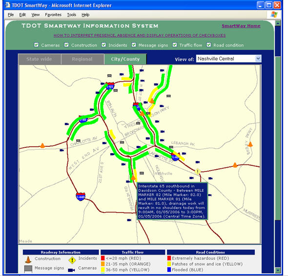
SmartWay provides real-time traffic conditions,
including live traffic images, messages from dynamic message boards,
roadway construction reports, incident reports, and road weather
conditions to the motoring public. Such information is distributed via
TDOT’s SmartWay website
and will also be made available through the proposed 511 system, a
three-digit phone number for critical travel information similar to 911
for emergencies and 411 for directory assistance.
With TDOT’s Information Technology (IT) Division at the helm, design of
the SmartWay data capture and distribution system, Tennessee SmartWay
Information System (TSIS), began in early 2005. The TSIS project was
created and initiated by the TDOT Community Relations Division (CRD)
with the goal of making vital roadway information accessible to the
public. TDOT’s IT Division provided the strategic direction for TSIS.
Two major subsystems were identified as follows:
- TSIS Reporting System (TRS) - Intranet roadway events reporting system,
- TSIS Mapping System (TMS) - Internet roadway events publishing system.
Using the TRS, roadway event information from the field
is entered into the SmartWay Oracle spatial database. All events are
identified by using base linear network identifiers and log mile
values. Such events include incidents, construction and weather related
road conditions. When these events are posted to the database, triggers
inside the database automatically generate the geometry to spatially
represent the events. Barring the generation of the spatial geometry,
which is performed within stored procedures inside the database, TRS is
entirely a browser based application implemented with Active Server
Pages (ASP) and hosted on Microsoft’s Internet Information Servers
(IIS). This subsystem was co-developed by the TDOT GIS Office and
Vanderbilt University in Nashville, Tennessee.
The TMS generates maps when events are reported or updated and
publishes them on the internet. In addition to generating roadway
events maps, TMS also creates maps for camera and message sign
locations and roadway traffic flow, when applicable. This subsystem was
co-developed by the TDOT GIS Office and GISbiz, Inc., a sub-contractor
to the ITPro (IT Professionals) prime contractor CIBER, Inc. Functional
aspects of this subsystem were divided into two major components:
- TSIS Map Generator (TMG) - Intranet map generation component
- TSIS Map Distributor (TMD) - Internet map distribution component
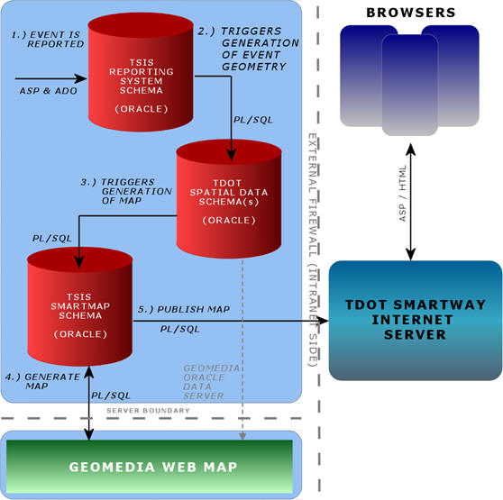 |
TMG works entirely from within the Oracle spatial
database as stored
procedures in order to smoothly integrate with TRS. TRS and TMG are
tightly coupled, and when roadway events are reported using TRS,
triggers in the database create event geometry and then automatically
notify TMG to generate updated maps. Upon notification, this component
generates new maps and posts them on the Internet server. Updated maps
are available to the user within one minute of events being reported.
This component (TMG) uses a simple metadata scheme to store information
about map parameters and uses these parameters to generate maps when
they are requested. All map generation is handled inside stored
procedures that use Oracle COM Automation API to directly communicate
with remote map servers, such as Intergraph’s GeoMedia Web Map Server,
which is currently being used to generate the maps. Once the maps are
generated, they are programmatically retrieved from the map server host
and posted on the Internet server. This architecture was chosen for its
efficiency, as event specific maps are only generated when events are
reported or updated. Base maps, including camera and message sign
location maps, which are not subject to frequent changes do not require
constant updates, and are therefore only generated once.
TMD is strictly a map serving component. No maps are generated by this
component, and it basically serves maps generated by its sibling (TMG),
by carefully overlaying requested event maps on top of their associated
base maps. This task is relatively simple, as all maps are generated in
Portable Network Graphics (PNG) format (all map images support tool tip
and hotspot actions where applicable) with transparent
backgrounds. Therefore, this component can serve any combination
of base and event maps for a given area, so long as such maps are
available. This component is implemented entirely in ASP and can serve
maps to any client that posts well-defined request parameters to the
page, including limited customization of headers, footers, map title
and map navigation controls.
TSIS is an innovative approach for publishing vital roadway information
to a large number of users. Compared to traditional applications that
both generate and serve event maps only when users request them, TSIS's
unique method of generating maps as soon as events are reported
translates into instantaneous availability to the user. Users also
benefit by receiving maps that function intelligently without requiring
a custom plug-in on the client's browser. Thus, detailed and
interactive maps are provided to the user both rapidly and securely.
TSIS, then, is a creative solution that allows a more efficient
management of resources for both providers and users as they deliver
and view the transportation data that improves our communities' safety,
mobility, and productivity.
 |