Johnston McLamb
has a well-defined methodology for
developing a decision support system for space optimization that is
customized to each customer's business. Space optimization is an
automated process for identifying properties that can be vacated by
moving the operations and assets within those properties to other
properties that have suitable excess space. Johnston McLamb
combines a visual business intelligence capability (showing properties
and related data on a map) with a cost model that uses available data
about the facilities and customer-specified business rules to determine
an optimum outcome that meets the customer's business objectives.
Organizations that are already doing some sort of space optimization often perform it manually, which can be very time-consuming and may lead to sub-optimal results. For example, one large enterprise required about three weeks to optimize space manually for a small subset of its facilities. The space optimization system that Johnston McLamb developed for the company did the same work in seconds, produced better results, and helped the enterprise meet its goal of achieving lease expense savings and revenue increases exceeding an estimated $100 million per year.
For many organizations, just providing the ability to see all facilities on a map is a major breakthrough. Interactive user controls and filters instantly provide different ways to look at facilities and drill down to details, which is much more illuminating than working with tabular reports of data. Decision makers can run "what if" scenarios, make decisions more quickly than ever, and react rapidly to changing marketplace conditions.
The companies that can benefit most from optimizing the space in their facilities are ones with more than 500 facilities, annual revenue in excess of $1 billion, and who already own the necessary technology (in this case, an Oracle database and Oracle Application Server). U.S. federal government agencies are also candidates if they own or manage space in more than 500 buildings. However, organizations of any size can improve their business operations using Johnston McLamb's space optimization methodology.
How Space Optimization Works
Normally, the primary objective is to minimize lease and ownership expense by combining facilities. This is accomplished by moving the operations and contents out of some facilities and then vacating them. As a result, owned facilities can be sold or leased to another tenant, and leased facilities can be vacated as soon as possible.
Space optimization takes multiple factors into account. In order to move the contents or operations completely out of a facility, there must be another facility with enough space to accommodate them. When moving the contents or operations of one facility to another, it might be desirable for the two facilities to be within a certain distance of one another. The new facility must be suitable for the contents and operations of the facility being vacated. For example, it might not be a good idea to move the operations of a retail facility to a warehouse in an undesirable location, even though the warehouse might have enough space available. Finally, vacating a facility might result in lease or ownership savings, but it costs money to make the move. Organizations want to know if the move makes sense financially.
Ideally, the user of a space optimization solution can specify parameters for the factors described above (and perhaps others). For example, one parameter might be the minimum amount of available space that must exist in a facility in order for it to be eligible to receive the complete contents or operations of another facility. Another parameter might be the maximum distance between facilities to be combined. Users might specify that facilities can be combined only if they have certain factors in common (e.g., the purpose for which the facility is used). If facilities can be combined only if the net cost savings over a future period of time is positive, then a parameter would be the maximum amount of time allowed to achieve a positive rate of return.
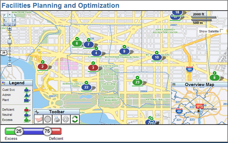
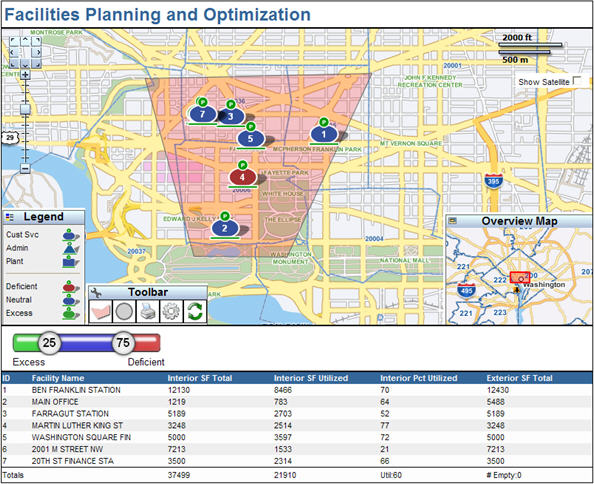
A space optimization system uses a cost model that considers all the factors and determines the optimum combination of facilities to achieve the desired objective. For example, if the desired objective is to maximize cost savings over the next three years, then the system determines the solution that results in the greatest net cost savings while staying within the constraints of space, proximity and suitability. The system consists of a web based user interface (UI) and a back end analytics component. The UI displays the locations of facilities on a map. Facilities are represented by icons that convey information about each facility. For one such system, Johnston McLamb designed icons that used color and shape to convey four types of information: type of facility, amount of space inside the building, amount of parking space and total site space (which included the land around the building). Depending on customer requirements, the icons could show other information such as whether the facility is leased or owned. To render the map, Johnston McLamb uses spatial tools built into Oracle Database (Locator) and Oracle Application Server (MapViewer).
The back end analytics component is a linear programming routine that utilizes software libraries such as LAPACK or LINPACK. This is typically programmed in Java, but other languages such as .NET or C++ could be used as well. The flexibility to use different technologies exists because Johnston McLamb is offering a methodology for developing a space optimization system, not a commercial off-the-shelf (COTS) product.
The Need for Good Data
The results of space optimization are only as good as the available data. The location of every property, recorded as latitude/longitude coordinates, is essential. If these data do not exist, Johnston McLamb uses a process called geocoding to create them from other data such as street addresses. The size of each facility and the amount of space being utilized and unused are also needed. The discrete business operations in each facility should be known as well, along with the amount of space needed to conduct each type of operation. Since it is not always necessary to move everything in a facility into just one other facility, it might be possible to move some operations to one facility and other operations to other facilities.
The organization should know the specific costs associated with each facility and when those costs would be eliminated if the facility were vacated. For example, if you vacate a leased facility after 18 months of a 24-month lease, the lease costs might not cease immediately or there could be a penalty. Also, costs might change if the location of the operation moves to another facility. For example, if two warehouses are combined into one, the inventory that was in each warehouse still has to be delivered to the same locations as before, but the delivery routes will change. This could result in an increase or decrease in the number of drivers needed and fuel costs.
Depending on the factors the user wants to take into account, many other types of data might be required as well. Frequently, all the needed data are not available. Or the data exist, but are scattered across many different siloed systems and databases. In this case, the approach is to implement space optimization in phases. The initial phases use the best data available. The results will not be perfect, but they should be much more accurate and significantly faster than a manual analysis or "best guess." A major part of any space optimization project is devoted to data analysis and data integration. In many organizations, that is more of a challenge than the development of the space optimization software. As the data get better, the results of the space optimization improve.
If the quality of an organization's data needs improvement, space optimization can be a great driver for that data quality improvement process. Improved data quality leads to better space optimization decisions, resulting in greater savings. And improved data integrity can open doors for better analysis and decision making across the enterprise. For large organizations, the cost savings and efficiency improvements can be significant.
Organizations that are already doing some sort of space optimization often perform it manually, which can be very time-consuming and may lead to sub-optimal results. For example, one large enterprise required about three weeks to optimize space manually for a small subset of its facilities. The space optimization system that Johnston McLamb developed for the company did the same work in seconds, produced better results, and helped the enterprise meet its goal of achieving lease expense savings and revenue increases exceeding an estimated $100 million per year.
For many organizations, just providing the ability to see all facilities on a map is a major breakthrough. Interactive user controls and filters instantly provide different ways to look at facilities and drill down to details, which is much more illuminating than working with tabular reports of data. Decision makers can run "what if" scenarios, make decisions more quickly than ever, and react rapidly to changing marketplace conditions.
The companies that can benefit most from optimizing the space in their facilities are ones with more than 500 facilities, annual revenue in excess of $1 billion, and who already own the necessary technology (in this case, an Oracle database and Oracle Application Server). U.S. federal government agencies are also candidates if they own or manage space in more than 500 buildings. However, organizations of any size can improve their business operations using Johnston McLamb's space optimization methodology.
How Space Optimization Works
Normally, the primary objective is to minimize lease and ownership expense by combining facilities. This is accomplished by moving the operations and contents out of some facilities and then vacating them. As a result, owned facilities can be sold or leased to another tenant, and leased facilities can be vacated as soon as possible.
Space optimization takes multiple factors into account. In order to move the contents or operations completely out of a facility, there must be another facility with enough space to accommodate them. When moving the contents or operations of one facility to another, it might be desirable for the two facilities to be within a certain distance of one another. The new facility must be suitable for the contents and operations of the facility being vacated. For example, it might not be a good idea to move the operations of a retail facility to a warehouse in an undesirable location, even though the warehouse might have enough space available. Finally, vacating a facility might result in lease or ownership savings, but it costs money to make the move. Organizations want to know if the move makes sense financially.
Ideally, the user of a space optimization solution can specify parameters for the factors described above (and perhaps others). For example, one parameter might be the minimum amount of available space that must exist in a facility in order for it to be eligible to receive the complete contents or operations of another facility. Another parameter might be the maximum distance between facilities to be combined. Users might specify that facilities can be combined only if they have certain factors in common (e.g., the purpose for which the facility is used). If facilities can be combined only if the net cost savings over a future period of time is positive, then a parameter would be the maximum amount of time allowed to achieve a positive rate of return.
A space optimization system uses a cost model that considers all the factors and determines the optimum combination of facilities to achieve the desired objective. For example, if the desired objective is to maximize cost savings over the next three years, then the system determines the solution that results in the greatest net cost savings while staying within the constraints of space, proximity and suitability. The system consists of a web based user interface (UI) and a back end analytics component. The UI displays the locations of facilities on a map. Facilities are represented by icons that convey information about each facility. For one such system, Johnston McLamb designed icons that used color and shape to convey four types of information: type of facility, amount of space inside the building, amount of parking space and total site space (which included the land around the building). Depending on customer requirements, the icons could show other information such as whether the facility is leased or owned. To render the map, Johnston McLamb uses spatial tools built into Oracle Database (Locator) and Oracle Application Server (MapViewer).
 |
The back end analytics component is a linear programming routine that utilizes software libraries such as LAPACK or LINPACK. This is typically programmed in Java, but other languages such as .NET or C++ could be used as well. The flexibility to use different technologies exists because Johnston McLamb is offering a methodology for developing a space optimization system, not a commercial off-the-shelf (COTS) product.
 |
 |
The Need for Good Data
The results of space optimization are only as good as the available data. The location of every property, recorded as latitude/longitude coordinates, is essential. If these data do not exist, Johnston McLamb uses a process called geocoding to create them from other data such as street addresses. The size of each facility and the amount of space being utilized and unused are also needed. The discrete business operations in each facility should be known as well, along with the amount of space needed to conduct each type of operation. Since it is not always necessary to move everything in a facility into just one other facility, it might be possible to move some operations to one facility and other operations to other facilities.
The organization should know the specific costs associated with each facility and when those costs would be eliminated if the facility were vacated. For example, if you vacate a leased facility after 18 months of a 24-month lease, the lease costs might not cease immediately or there could be a penalty. Also, costs might change if the location of the operation moves to another facility. For example, if two warehouses are combined into one, the inventory that was in each warehouse still has to be delivered to the same locations as before, but the delivery routes will change. This could result in an increase or decrease in the number of drivers needed and fuel costs.
Depending on the factors the user wants to take into account, many other types of data might be required as well. Frequently, all the needed data are not available. Or the data exist, but are scattered across many different siloed systems and databases. In this case, the approach is to implement space optimization in phases. The initial phases use the best data available. The results will not be perfect, but they should be much more accurate and significantly faster than a manual analysis or "best guess." A major part of any space optimization project is devoted to data analysis and data integration. In many organizations, that is more of a challenge than the development of the space optimization software. As the data get better, the results of the space optimization improve.
If the quality of an organization's data needs improvement, space optimization can be a great driver for that data quality improvement process. Improved data quality leads to better space optimization decisions, resulting in greater savings. And improved data integrity can open doors for better analysis and decision making across the enterprise. For large organizations, the cost savings and efficiency improvements can be significant.
From Our Homepage
Saying Farewell to an Amazing Journey
Communicating with Maps
Is There a GIS Career Ladder?
What does it mean to be geospatially smart? Series
Ways Real Estate and Property Developers Utilize Melissa GeoData for Data-Driven Decisions
Unlocking Value From Daily Satellite Imagery and Insights
Maximizing the Value of Your Address Data with Geo Addressing
How Indoor Mapping Enhances the Security of Smart Buildings
Look Ahead: AI, Location Intelligence and Efficiency
Collaboration Takes on Sea Level Rise & Dynamic Technology Environments
Brownies for Brownfields
Has Everything Been Mapped Already?
How Is Data Literacy Changing in an Artificial Intelligence Landscape
Portfolios for GIS Professionals: More Than Just Maps
How to Create a Distance Matrix in QGIS - A Step-by-Step Guide
7 Ideas for Bringing GIS into the K-12 Classroom
The Geography of Movement