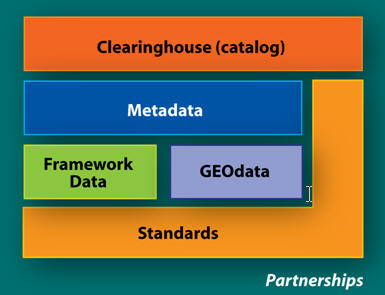
However, we often do not fully recognize the importance of the OGC as a forum for collaboration. The Consortium now consists of over 360 members from around the world who bring perspectives, needs and interests from many segments of the global geospatial community. OGC collaborative processes have worked well for its membership as a foundation for developers and users to work together to develop and advance the use of geospatial standards. In particular, the OGC Interoperability Program and its Compliance Testing Program bring organizations together in a manner that helps create a climate of collaboration. I believe that we should also look at that collaboration effort as part of a larger picture. Throughout the world, there is a tremendous amount of work taking place to develop and implement federated geospatial enterprises, or Spatial Data Infrastructures (SDIs), to modernize the collection, management, sharing, use and dissemination of geospatial data. By their very nature, these activities require a high level of coordination and cooperation between public and private sector entities. As SDIs are being implemented in nations and regions around the globe, we see a great deal of commonality in their building blocks. A good depiction of these common elements is shown in Figure 1.
 |
This is a diagram used by the U.S. Federal Geographic Data Committee to show the components of the U.S. National Spatial Data Infrastructure and their relationship to each other. While this diagram is from the United States, it generally represents the major components of SDIs around the world. In particular, we should note that two elements of the NSDI touch all others. These are Standards and Partnerships (or Collaboration). These two components are the keys to technical and institutional interoperability within and between SDIs and the federated geospatial networks that fuel them. Standards and Partnerships are core to the central mission of the OGC. You could ask, however, is there a larger role for OGC in helping bring the full societal, economic and scientific benefits of geospatial information and technology into commercial and institution processes worldwide?
OGC’s diverse membership spans industry, government and academia from numerous nations. This diversity of participation results in unique collaborative partnerships across many different domains. With the wide reach of its membership, OGC offers tremendous opportunities for continued expansion in this area. While the OGC is viewed as the lead organization for developing technical specifications, it can likewise provide a greater leadership role in fostering a climate for collaboration. The willingness of OGC staff and members to work as a community using an open, inclusive, user-driven and fast process is a model that can serve the geospatial community well in many different areas. OGC is partnering with the ISO Technical Committee for Geographic Information/Geomatics, with the Global Spatial Data Infrastructure Association and many others to advance standards and interoperability. OGC plays a strong leadership role in broad interoperability efforts such as Empire Challenge and the Global Earth Observing System of Systems. These types of initiatives foster new collaborative interactions and set the stage for long-term agreements for interoperability. By reaching out not only to the geospatial community around the world but also to those who will greatly benefit from better availability and use of geospatial information and technology, we can help accelerate the adoption of open interoperable geospatial architectures and infrastructures and tap into the creative energies of others to stimulate new and innovative uses and applications. Collaborative environments are difficult to achieve and maintain over time. OGC has a proven track record of keeping a balance between a structured steady course and the rapid adaptation and assimilation of new ideas. As we address the opportunities offered in the future, we can do even more as OGC to foster a climate of collaboration and to fully enable organizations and citizens with the relationships, tools and geospatial data that can help make their lives better.