While satellite imagery can provide an excellent framework by which users may develop plans of action in various situations, many circumstances demand a closer look. For a government entity or enterprise, an accurate and complete imagery base map is a critical dataset that serves a variety of purposes such as infrastructure management, urban planning, cartography, utilities planning, taxation, environmental issues, transportation coordination, logistics and security.
Typically, imagery data are sourced over the course of many years from a variety of vendors that utilize different imaging systems, processing techniques and specifications. Unfortunately, this process often results in inconsistencies, gaps in coverage and issues with positional accuracy and quality, all of which ultimately are likely to impede workflows and decisions. End-users of the imagery require complete coverage of high-quality, cloud-free imagery with high positional accuracy. Furthermore, end-users must maintain the ability to share a single source dataset, which is critical to ensuring that decision making and analysis are expedient and precise.
As a result of these requirements, the use of satellite imagery alternatives, such as planimetric imagery, has become increasingly popular among end-users. For example, DigitalGlobe’s Precision Aerial product collects imagery using a common sensor and platform at a uniform resolution with standard specifications. This provides consistent country and regional coverage, making integration and analysis easier. Additionally, DigitalGlobe Precision Aerial provides wall-to-wall, complete country imagery coverage processed to a rigorous specification. No matter what the usage or the geography, end-users can be confident they are making the best decision possible in terms of imagery providers, and they have the assurance that colleagues and sub-organizations are also referencing the same consistent data in their workflows.
In terms of use case scenarios, local communities have found a myriad of uses for planimetric imagery in recent years. For example, Jackson County, Georgia has been one of the fastest growing counties in the United States for the past decade. In 2007, the Jackson County Board of Commissioners formed a GIS department to help track and manage growth, as well as streamline county records and processes. Jackson County uses GIS extensively to inform 911 dispatchers, aid in city planning, and appraise real property.
At the heart of any successful GIS system is the need for new and updated orthoimagery. In 2009 Jackson County was able to fly imagery and LIDAR, but like most local governments, Jackson County has not had the funding to commission a new flight. Jackson County continues to see negative growth in tax digest (total taxable value of property), which is one of the largest sources of funding for local government. Regardless of the level of available funding, tracking change in a high growth community remains vital for essential government functions such as rapid 911 and EMS response in order to ensure public safety. For example, 911 dispatchers and first responders must have accurate data on structure placement and road changes due to highway realignment.
Fortunately, with the help of DigitalGlobe Precision Aerial, Jackson County has been able to afford accurate, up-to-date imagery at a fraction of the price of commissioning its own flights. Within two weeks of receiving Precision Aerial imagery from DigitalGlobe, the Jackson County GIS department had detected over 1,100 changes to buildings and had installed the new imagery into its emergency response system. The product has saved Jackson County at least $30,000 in flight costs and has allowed staff to efficiently track important changes in the county. According to GIS Manager Joel Logan, “The imagery has been really great and affordable. We have a slew of road changes. I don’t know what we would do without it.”
While Jackson County utilizes planimetric imagery products such as DigitalGlobe Precision Aerial in a professional setting, customers may also monitor many world locations from the convenience of their office or home. Not only does this significantly improve overall efficiencies for governments and organizations by reducing or eliminating the need for regular on-site visits, but it also allows customers to access content within weeks of acquisition. From defense to commercial interests, this timeliness allows for rapid and informed decision making related to ground-based information.
With many recent disastrous events, both natural and man-made, customers in industries worldwide have required the most accurate and immediate coverage for both response and planning. Companies such as DigitalGlobe have simplified imagery procurement and accelerated decision making by providing off-the-shelf, complete aerial coverage for any area requirement in the contiguous United States and Western Europe. In order to accomplish these important missions, DigitalGlobe Precision Aerial (available through DigitalGlobe’s Advanced Ortho Series product line) leverages Microsoft’s UltraCamG digital imaging technology to provide comprehensive coverage with industry-leading quality and accuracy. This product will provide a wall-to-wall collection of 30 cm natural color and 60 cm color infrared aerial orthomosaics covering the contiguous United States, Austria, Belgium, Denmark, Ireland, France, Italy, Netherlands, Portugal, Spain, Switzerland and the United Kingdom (also includes coverage for Andorra, Liechtenstein, Gothenburg, Helsinki, Monaco, Malta, Oslo and Stockholm); with 15 cm natural color and 30 cm color infrared offered in Germany.
Precision Aerial imagery products are captured in one degree latitude by one degree longitude blocks (equal to about 10,000 km²) for complete country coverage. As a result of the unique partnership between DigitalGlobe and Microsoft, both the United States and Europe will have complete coverage by mid-2012. Furthermore, due to DigitalGlobe’s stringent quality control standards, Precision Aerial products will include imagery with zero cloud cover, haze, smoke and pollution in metro areas, and less than one percent cloud cover in remote areas. U.S. cities are flown leaf-off to provide maximum detail observation.
In addition to complete, quality coverage, products such as DigitalGlobe’s Precision Aerial are easy-to-use and cost-effective. Precision Aerial products are optimized on a single application-ready, standard format. They are available on a common platform with uniform resolution and captured by a single sensor, all of which contribute to providing a consistent country and region-wide mosaic. If, for example, a customer decides they wish to merge existing or other vendor data, these standard formats mesh easily with other datasets. Furthermore, DigitalGlobe offers flexible licensing and use rights, including copy, save, download, distribution, transmit and manipulation capabilities. As for delivery, users should receive imagery within four to six weeks of flight completion.
Precision Aerial products stand as an ensign for the industry and set an unparalleled precedent for high-quality country-wide mapping and data availability. As the first phase of this program completes in 2012, DigitalGlobe intends to stay on the leading edge and push the standards, resolution, coverage and area even further. As a testament to the value and quality of the content being used in various applications, including parcel boundaries, location services, civil engineering, land management and urban planning, DigitalGlobe’s Precision Aerial Product was recently recognized by the Management Association for Private Photogrammetrists and Surveyors (MAPPS) in the U.S., which awarded the product its Geospatial Excellence Award.
Satellite imagery, such as DigitalGlobe’s, has been used for decades in a myriad of industries and use cases, including commercial, location-based, defense and rescue operations, where quality and accuracy are of utmost importance. However, planimetric imagery products like Precision Aerial offer premium coverage at unprecedented volume. Due to its off-the-shelf nature, DigitalGlobe is able to license the data as a cost-effective and practical solution to align with any budgetary requirement.
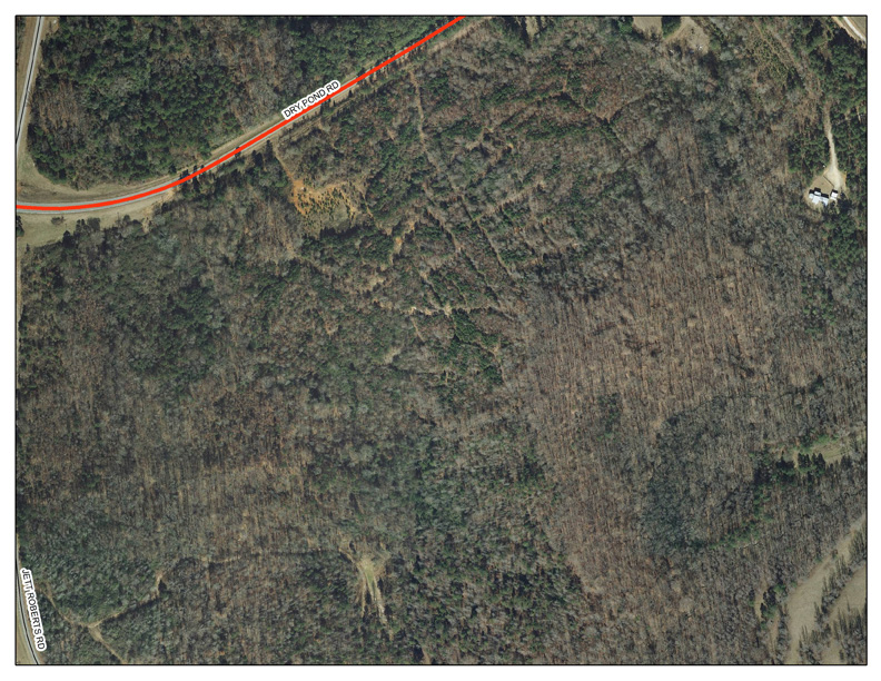
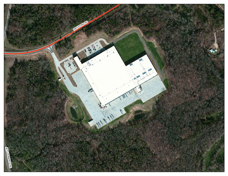
FIGURE 1: Aldi Regional Distribution Center, Jackson County, GA,in 2009 (top) and 2011 (bottom) [Click for larger image]

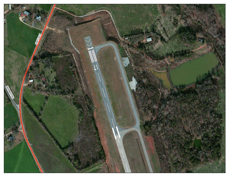
FIGURE 2: Jackson County (GA) Airport Runway Extension in 2009 (top) and 2011 (bottom) [Click for larger image]