 Imagery is
the new…
Imagery is
the new…There were discussions this week among those who attended the ESRI conference about whether there was anything "new." I will say from looking over the coverage and announcements that the focus on imagery and new uses for it rekindle my thoughts that imagery has stepped to the fore as the "hot" data type, joining 3D data at the top of the list.
While we are not yet doing heavy duty image analysis, the business of collecting, distributing and doing a better job of using ortho and oblique imagery is "busting out all over." Here's some evidence from news items just from the past week or so.
Pictometry
 |
 |
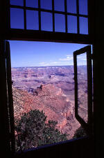
It's worth noting that Pictometry doesn't just provide the oblique images; it offers tools to get more information out of imagery - the ability to measure the height of windows off the ground, for example, and soon the ability to create (not as precisely as the Harris-created ones) 3D models of their own. The company has a created a compelling "new" product in the imagery space. Further, because Pictometry offers both software and imagery (core data), and not just imagery as most other aerial/satellite providers do, it has a different place in the market than data providers. It is, perhaps, offering a package not unlike the early GIS vendors: GIS + data. (MapInfo, Strategic Mapping and others used that model for some time, until data became a bit of a commodity.) [Note: The Pictometry image used in the 3D line of site model at above left was taken by Simmons Aerofilms, a subsidiary of the Blom-ASA Group.]
 |
 |
 |
Red Hen Systems' solution for enterprise use of still imagery (video too, soon) depends on ESRI's ArcSDE and ArcIMS software. It allows real time updates from the field via e-mail that are immediately available to anyone within the enterprise via a Web browser. It includes version control, as well.
Video gets little coverage in GIS, save in pipeline apps. Red Hen is the only player I know in this space. Video use in GIS can only grow. What happens when GPS information is routinely incorporated into video? Will we see the explosion of geocoded "films" that we now see for geocoded still images on the Web? How will they be used in geospatial applications?
Also interesting to note is this statement in the press release: "Red Hen Systems, Inc. holds patents on methods for collecting GPS coordinates with still pictures and video."
More data points
- This past week DigitalGlobe took delivery of its new bird, WorldView 1, from ITT.
- Global Relief Technologies just set up a Virtual Network Operations Center at Pease Tradeport in Portsmouth New Hampshire. The company supports a variety of federal agencies with homeland security, relief and defense issues. The key offering? The ability to collect and transmit "GPS-referenced data, including satellite imagery … between emergency responders and operations centers during natural or man-made disasters."
- To support the imagery (and other modeling needs) come new 3D models of Western Europe from Intermap, pushed up for delivery by customer demand.
- There's GlobeXplorer imagery (free and for a fee for ArcGIS Explorer/ArcWeb Explorer).
- Pixia is developing a prototype system to quickly distribute imagery to analysts and emergency responders in support of hurricane preparedness and response activities.
- MultiVision USA, a competitor to Pictometry, showed off its MultiVision which offers enhanced functionality for viewing and measuring oblique aerial imagery within a GIS-based environment.
- LizardTech displayed, at the ESRI Conference, its latest image compression and exploitation tool, GeoXpress, which supports "non-uniform color balancing, geography markup language (GML) for JPEG 2000 (JP2) support and enables users to easily load imagery directly into Oracle Spatial."
Here are some suggestions.
Google, Yahoo and Microsoft (GYM), along with others including open source World Wind, have rekindled a demand for up-to-date, high resolution, easy to buy/access imagery.
Microsoft's licensing of Pictometry data for Live Local has helped educate potential new Pictometry users on its offerings.
GIS use of imagery (vs. an image analysis package) is quite basic and continues to focus on imagery as a backdrop or drape. Imagery use in situational awareness and change detection is growing, especially for emergency response.
The marketplace is responding to demand by trying to "own the data," "add value to the data," or "be the delivery mechanism for the data." That's all very Web 2.0.
Like others in the Web 2.0 world, imagery businesses are searching for the appropriate business model. How is imagery licensed? How are imagery Web services priced? And, down the road, when such imagery is a commodity, what will be the "value add," or the unique products from one vendor over another?
What's missing?
What challenges are imagery data and software players not yet addressing?
Metadata delivery. By that I mean making it simple for a user of data to access and use metadata. That's nearly impossible on GYM sites beyond a year of copyright.
Distinguishing data and software products. There's quite a lot of educating to be done in the imagery arena. A vendor was recently asked why one would use its Web mapping platform over Google Earth. The answer was less than convincing.
More compelling products. A few in recent years have popped up; I've noted Pictometry, and will add VLS' Feature Analyst. What's next?
Conclusion
Imagery is not a stepchild or special data type any longer. It's storable in databases. It's servable on the Web via servers from many vendors. It's compressible for ease of distribution. It's more searchable than ever before. There are usable formats (GeoTIFF, GMLJP2) that include location information in standard ways. Moreover, the bar for imagery use has been set higher in part because of the vendors described above, and in part by vendors including GYM. Imagery is the new gas in the tank of our GISs.
From Our Homepage
Saying Farewell to an Amazing Journey
Communicating with Maps
Is There a GIS Career Ladder?
What does it mean to be geospatially smart? Series
Ways Real Estate and Property Developers Utilize Melissa GeoData for Data-Driven Decisions
Unlocking Value From Daily Satellite Imagery and Insights
Maximizing the Value of Your Address Data with Geo Addressing
How Indoor Mapping Enhances the Security of Smart Buildings
Look Ahead: AI, Location Intelligence and Efficiency
Collaboration Takes on Sea Level Rise & Dynamic Technology Environments
Brownies for Brownfields
Has Everything Been Mapped Already?
How Is Data Literacy Changing in an Artificial Intelligence Landscape
Portfolios for GIS Professionals: More Than Just Maps
How to Create a Distance Matrix in QGIS - A Step-by-Step Guide
7 Ideas for Bringing GIS into the K-12 Classroom
The Geography of Movement