 The
Mystery of Yahoo Maps Imagery
The
Mystery of Yahoo Maps ImageryLike many, I was jazzed recently when Yahoo added imagery to its Yahoo Maps offering. And, like many, I was curious about its source. I could find nothing on Google Maps’ website about the imagery. I wrote a blog entry hoping someone from Yahoo might share the sources. No luck thus far.
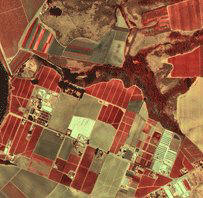
Over time, tidbits are being revealed. I first read about USGS quads as sources for Yahoo's imagery in a comment to a post by James Fee at Spatial Adjusted. The poster cited a colleague who knew of a company that had helped "colorize" the black and white DOQs. He pointed out some oddities when old black and white images were meshed with newer "multispectral satellite data." My first thought was that's a lot of work to fix up what are rather old images.
But, that's certainly the source of at least some of the imagery, per Michael Lawless, a Yahoo product manager. He notes at the Yahoo Search Blog that indeed Yahoo is "using a lot of USGS data in the backfill, as well as other government sources that are much newer than that." He does point to U.S. and international updates that are expected soon.
Sean Gilles at Import Cartography confirms that i-cubed is the source of at least some of the imagery, likely exactly the imagery noted above. (I saw that company's copyright in the map window when I first checked out the imagery.) You can read up on the colorization process courtesy of i-cubed.
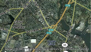 |
The other copyright notice you might find as you explore Yahoo Maps is from Aerials Express. Just that name might suggest aircraft and not satellite imagery, but nearly all press coverage of Yahoo's additions cites "satellite imagery."
Gary Price at ResourceShelf (he also works at Ask.com, but not in the mapping part) notes Yahoo offers "Aerial/Satellite imagery provided by Aerials Express, NASA, i-cubed, MDAFederal." I did find some MDAFederal imagery, but despite my best efforts, I could not get NASA to show up as a source. I suspect that's what "other government sources" means.
And, just to confuse things more, Forbes this week reports that Yahoo is working with GeoEye (the combination of ORBIMAGE and Space Imaging, after an acquisition). E-mails to Yahoo for confirmation have gone unanswered. But, an interview from April 20 has Michael Lawless, Yahoo Maps product manger, confirming working with GeoEye.
So, why the big mystery? Unlike other licensees of imagery or vector road data who allow the selected vendors to scream it from the rooftops, why is Yahoo not even mentioning the vendors’ names? Why do bloggers and librarians need to dig up this very high level metadata? Frankly, I’m puzzled.
Will Mapping Portals Drive Commercial Remote Sensing?
At one time I edited an imaging magazine and asked the same question many other folks asked: what's the future of commercial satellite remote sensing? Back then the commercial side of the house was quite small, with most of the funds coming from government sources. That's still true – but now consumers and thus business people and their kids – are becoming far savvier about satellite imagery.
 |
So, will this ubiquity of imagery drive more commercial sales? Here's what we know: GeoEye provides imagery to Microsoft and Yahoo. DigitalGlobe provides its images to Google. Ask.com uses GlobeXplorer, which offers up many sources of satellite and aerial imagery. Space.com reports that neither of the satellite firms will disclose the nature or size of its contract, but both indicate it is evidence of a growing commercial market. Ed Jurkevics, an analyst with the firm Chesapeake Analytics, is quoted as saying that consumers and small business will be the third largest customer of satellite imagery in the coming years, after government and foreign ground stations.
Jurkevics goes on to speculate that current contracts from mapping portals with satellite imagery providers total about $25 million annually today. With demand for international sites and 3D growing, he expects that to jump five or six times in the coming years. He's quick to point out this depends quite a lot on the fickle consumer: "But if all of this fails to produce consumer interest, these expenditures won't develop."
So, the question comes back to this: does making imagery ubiquitous create demand for it? For a parallel, consider vector GIS data. Is there demand for it? Yes, indeed. Why? I'd suggest the answer is that there is so much you can do with it – routing, location-based services, emergency response, traffic management, geocoding… And, that means that NAVTEQ and Tele Atlas have many, many clients in the public and private sector. Satellite imagery? There are certainly things you can do: change detection, aerial analysis, feature extraction, etc., but those haven't yet been commercialized in the same way. For now, most users of portal imagery are "just looking at pictures." In short, the public (and thus the commercial sector) will need to see and learn more about these sorts of applications and uses, just like they have over the years with vector data uses.
From Our Homepage
Saying Farewell to an Amazing Journey
Communicating with Maps
Is There a GIS Career Ladder?
What does it mean to be geospatially smart? Series
Ways Real Estate and Property Developers Utilize Melissa GeoData for Data-Driven Decisions
Unlocking Value From Daily Satellite Imagery and Insights
Maximizing the Value of Your Address Data with Geo Addressing
How Indoor Mapping Enhances the Security of Smart Buildings
Look Ahead: AI, Location Intelligence and Efficiency
Collaboration Takes on Sea Level Rise & Dynamic Technology Environments
Brownies for Brownfields
Has Everything Been Mapped Already?
How Is Data Literacy Changing in an Artificial Intelligence Landscape
Portfolios for GIS Professionals: More Than Just Maps
How to Create a Distance Matrix in QGIS - A Step-by-Step Guide
7 Ideas for Bringing GIS into the K-12 Classroom
The Geography of Movement